
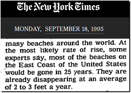
In 1995, the New York Times predicted that most East Coast beaches would be gone by 2020.
Scientists Say Earth’s Warming Could Set Off Wide Disruptions – The New York Times
The exact opposite has happened.
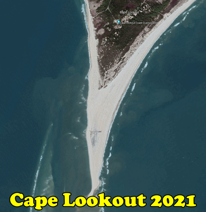

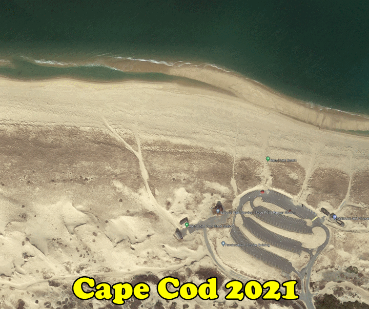
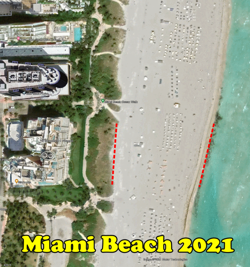
In 1995, the New York Times predicted that most East Coast beaches would be gone by 2020.
Scientists Say Earth’s Warming Could Set Off Wide Disruptions – The New York Times
The exact opposite has happened.

Tony: Are these comparison photos each at the same tidal node or anti node? Because just looking at today for Miami Beach, the high vs low tide is a delta of about 2.4 feet; (which at the slope of Miami Beach in Google Earth, is about 100 feet of sand covered or not covered between high and low tide)
https://www.usharbors.com/harbor/florida/miami-beach-fl/tides/
In other words it’s relatively easy for a true believer in the Climate Cult Narrative to debunk your photos with normal tidal variations.
Still even if the old photo were at high tide and new photos at low tide, it shows there is not some runaway sea level rise… but true believers will not accept this.
I do not think that there is much to debunk as literally all coasts look the same as they did 30 /50 /70 years ago.
And if we go by expert predictions, even the lowest low tide nowadays should be way above any high tide from 50 years ago.
But as a good starting point may be for everyone :to pick some dozen photos from each year for a specific place and compare them to 2024 photos.
That way we will get an overall tide average the random way.
Especially manmade buildings in the sea (Fort Denison,Statue of Liberty,Bishops Rock) can easily be memorized and sea level rise impossible to hide.
And as I already said some years ago – if there was any relevant sea level rise, we would have some kind of ” drowned Island – day /month”
and they would be busy to rub us the names of all those lose islands every day in our face.
How about a little older.
An Accurate Map of North and South Carolina With Their Indian Frontiers, Shewing in a distinct manner all the Mountains, Rivers, Swamps, Marshes, Bays, Creeks, Harbours, Sandbanks and Soundings on the Coasts, with The Roads and Indian Paths; as well as The Boundary or Provincial Lines, The Several Townships and other divisions of the Land in Both the Provinces; the whole from Actual Surveys by Henry Mouzon and Others
Date Published 1775
Date Depicted 1775
http://dc.lib.unc.edu/cdm/ref/collection/ncmaps/id/125
Compare with a side by side google map and most of the features are still there. A side note that 1775 was at the end of the Little Ice Age and a whole lot of ice was on shore and not in the ocean. – See Glacier Bay NP.
Glacier Bay was first surveyed in detail in 1794 by a team from the H.M.S. Discovery, captained by George Vancouver. At the time the survey produced showed a mere indentation in the shoreline. That massive glacier was more than 4,000 feet thick in places, up to 20 miles wide, and extended more than 100 miles to the St. Elias mountain range
That’s 1 watershed valley.
As I recall, when I was on Miami Beach, it quickly dropped off a hundred yards or so from the beach. Anyway, certainly the tides should be the same in each photo, but how do you prove that you have done that, and they certainly don’t follow the rules of comparing equals to equals.
Agree. Aerial beach photos is like chumming the water for sharks.
OTOH, tide level gauges will usually induce silence or get you blocked (or both). It is much harder for the hard-core believer to answer for why the gauges show no increase in the rate of sea level rise since the 1800s. Religious fanatics aren’t interested in learning any unimpeachable facts that would destroy their fragile paradigm.
To be fair, the Virginia Beach sand erodes and is periodically replaced by pumping in sand from offshore. However, not far from Point Lookout, is a place called The Point, which is the western tip of Emerald Isle. I have been going there for decades and the sand was washing out for a while, but has been filling back in for years.
Beaches ebb and flow. The NYT is full of it.
All sand beaches erode. All sand beaches are ex mountains. As long as you have a river bringing the ex mountain to the sea you’ll have beach formation.
Wrong, wrong, wrong and wrong- Isn’t religious fanaticism great! They still believe Mickey, the Rodent.
Well the best measure is to compare the waterfront to something fixed, that is neither moving up/down or back/forward with respect to the land mass. If the ocean is not getting closer to this thing, then we might surmise that the oceans do not seem to be filling up at much of a pace. If sand is filling the beaches, then wouldn’t we expect the oceans to rise, the water having been displaced by sand (a rhetorical question, I’m pretty sure that the volume of sand is miniscule compared to the volume of the ocean)? I have been told that, here in Northern California, the beaches erode every winter, wave action from storms, I guess. Then they repopulate with sand in the summer, whether that is mountain erosion deposits, I don’t know.
Gravity is constantly pulling everything above sea level to below sea level aided by the land water cycle. On the other hand, continental drift is working to push land masses back up above sea level. Without knowing for sure which equation is winning, i would guess that the forces pulling land masses down would be far in advance of the slow-moving drift of continental plates. It wouldn’t surprise me at all if the 1 or 2 mm per year of sea level rise observed in the modern era is significantly due to erosion of land above sea level and transported by various means to the sea.
And, from the tide gauge data I have seen, whether it’s an obduction zone or subduction zone, there has been no recorded increase in the rate of sea level rise. That indicates to me there has been no appreciable increase in land ice melting into the seas over a tide gauge’s recording time span.
That type of inconvenient data should be maddening for alarmists living in their world of make-believe. But, they live in make-believe, where reality has no effect at all and are impervious to disillusionment. The global warming alarmist is the consummate useful idiot.
That’s an interesting point.
But in this case we should be able to observe land level rise in urban heat island areas compared to the asphalt and concrete free surrounding areas.
But my main problem with this is the constant coverage with dust etc,
that has buried cities and even Pyramids.
+ it should be very problematic for geologists to find layers and segments of earth of past times with such an erosion.
As amateur i’d be more interested in the gravitational effects of the sun on earth(if there are any) in terms of varying distance.