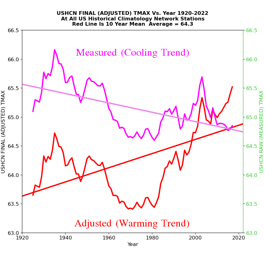
Almost half of NOAA US final adjusted temperature data is now fake.
Disrupting the Borg is expensive and time consuming!
Google Search
-
Recent Posts
- Analyzing The Western Water Crisis
- Gaslighting 1924
- “Why Do You Resist?”
- Climate Attribution Model
- Fact Checking NASA
- Fact Checking Grok
- Fact Checking The New York Times
- New Visitech Features
- Ice-Free Arctic By 2014
- Debt-Free US Treasury Forecast
- Analyzing Big City Crime (Part 2)
- Analyzing Big City Crime
- UK Migration Caused By Global Warming
- Climate Attribution In Greece
- “Brown: ’50 days to save world'”
- The Catastrophic Influence of Bovine Methane Emissions on Extraterrestrial Climate Patterns
- Posting On X
- Seventeen Years Of Fun
- The Importance Of Good Tools
- Temperature Shifts At Blue Hill, MA
- CO2²
- Time Of Observation Bias
- Climate Scamming For Profit
- Climate Scamming For Profit
- Back To The Future
Recent Comments
- Bob G on Analyzing The Western Water Crisis
- Bob G on Analyzing The Western Water Crisis
- Bob G on Analyzing The Western Water Crisis
- arn on Analyzing The Western Water Crisis
- Scott Allen on Analyzing The Western Water Crisis
- conrad ziefle on Analyzing The Western Water Crisis
- conrad ziefle on Analyzing The Western Water Crisis
- Bob G on Analyzing The Western Water Crisis
- Bob G on Analyzing The Western Water Crisis
- Bob G on Gaslighting 1924


How does this square with the reported global average temperature from the website
https://temperature.global/ which says it uses inputs from the following:-
NOAA Global METARs
NOAA One-Minute Observations (OMOs)
NBDC Global Buoy Reports
MADIS Mesonet Data
Are these sources of temperature data compromised or reliable?
Temperature Global does not adjust or alter the raw data. In fact a large proportion of the data gathered and displayed by Temperature.Global, is from aviation data as in the METAR. Every airport, above a certain size has half hourly METAR data. And it is imperative that it is accurate for aviation safety as pilots must know the temperature, dewpoint and pressure to calculate the takeoff and/or landing performance of both small aircraft and airliners.
To fudge any of that data would cause aviation accidents. Here is a complete rendering of all 67,828 airport METAR’s world wide: (pull on the tab at the bottom labeled “explanation”)
https://metar-taf.com/
As to why this data must be accurate, pilots of all aircraft have critical parameters for both engine performance and aerodynamic performance. You need to know for example what the air temperature is, and what the dewpoint is. When these two are close together, there is high likelihood of fog, which means limited visibility. When you have visible precipitation – even flying through cloud or fog, which are composed of microscopic water droplets, if the temperature is between -10 and +10 C you can get icing on wings and engine intakes. So you need to know if you need to avoid that area, or to switch on anti ice functions. Also computing the density altitude is important, because both engines and wings do not perform very well at low densities, i.e. when the density altitude is high so you need to know if your plane can actually take off on such and such runway length given the aerodynamic performance based on this data.
But the most crucial information is the pressure, or more commonly known as the Altimeter Setting. All planes use pressure based altimeters. They are calibrated for mean sea level pressure, which is 29.92 inches of mercury or 1013 hPA. There is a knob on every altimeter to adjust for the local air pressure, which adjusts the altimeter reading. If you took off from an airport with high pressure and fly to one with lower pressure, your altimeter will not read the altitude correctly unless it is adjusted to the landing airport pressure. And in fact your plane would be much closer to the ground than the altimeter reads if this adjustment is not performed for the lower pressure airport.
So for a number of reasons, you can trust METAR data over and above almost all other data. With the small caveat that the instruments are located at airports, which can be a bit warmer than rural areas nearby. But this must be the case because the pilots need to know the actual conditions at the airport, not out in the countryside.
To obtain a pilot’s license, one needs to learn a great deal about weather, weather data and forecasting. I submit most pilots are far better at reading the weather and forecasting than most meteorologists!
Likewise, Tony gets his data from the raw information, not the adjusted values by Climate Cult adherents with their fingers on the scale.
That was very informative. Thx
iMannginary is a synonym for fake, and Mannipulation is a synonym for data adjustment.
IPCC’s Mann and Jones ERASED The Medieval Warming Plateau to invent the “global warming” hoax. Five prior such Plateaus demonstrate increasingly hotter temperatures the further back in time they occurred. All five were also erased by Mann and Jones. Precedents established, NOAA and NASA followed suit, getting in on the same act.
Climate Change/Crisis/Emergency
does and can not exist outside the realm of data adjustment.