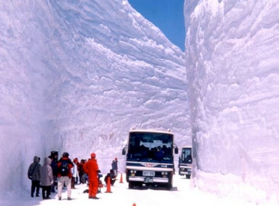
Weather Extremes : Record Snow Depth (for an official site) Measured in Japan | Weather Underground
Disrupting the Borg is expensive and time consuming!
Google Search
-
Recent Posts
- The Real Hockey Stick Graph
- Analyzing The Western Water Crisis
- Gaslighting 1924
- “Why Do You Resist?”
- Climate Attribution Model
- Fact Checking NASA
- Fact Checking Grok
- Fact Checking The New York Times
- New Visitech Features
- Ice-Free Arctic By 2014
- Debt-Free US Treasury Forecast
- Analyzing Big City Crime (Part 2)
- Analyzing Big City Crime
- UK Migration Caused By Global Warming
- Climate Attribution In Greece
- “Brown: ’50 days to save world'”
- The Catastrophic Influence of Bovine Methane Emissions on Extraterrestrial Climate Patterns
- Posting On X
- Seventeen Years Of Fun
- The Importance Of Good Tools
- Temperature Shifts At Blue Hill, MA
- CO2²
- Time Of Observation Bias
- Climate Scamming For Profit
- Climate Scamming For Profit
Recent Comments
- Bob G on The Real Hockey Stick Graph
- Bob G on The Real Hockey Stick Graph
- arn on The Real Hockey Stick Graph
- Bob G on The Real Hockey Stick Graph
- arn on The Real Hockey Stick Graph
- Bob G on The Real Hockey Stick Graph
- Bob G on The Real Hockey Stick Graph
- Gordon Vigurs on The Real Hockey Stick Graph
- arn on The Real Hockey Stick Graph
- arn on The Real Hockey Stick Graph


Incredible photo!
Wow! That….is a lot of cotton.
You want snow? You got it!
Snow. You want snow?
“You can’t handle the” snow!!!
: )
Not sure I’d be prepared to walk under that… how stable is it?
It’s warm snow, Will. Very safe.
But then again honestly, I agree with you.
It will be OK so long as it is not rotten snow.
Must be one heck of a snow blower, much better than mine.
Fukushima radiation has caused the snowflakes to mutate to 100 times their normal size.
GE brings good things to life.
Hey that’s the plot of the new Michael Bay/Steven Spielberg movie staring Leonardo DiCaprio.
I love the Japanese approach to safety.
Warning cones in the centre of the track………..under a 20 metre vertical wall of snow!!!!
Banzai!!!!!
Reblogged this on pindanpost.
I wondered about the honesty of your headline, but as this record was set yesterday you are correct. Another extreme weather event, wasn’t it?
Another record stupid comment.
RE: JohnM – “Another extreme weather event”
It was an interesting shift in 2012, wasn’t it. The meme-shift picked up in earnest with hurricane Sandy, and now has continued into winter snow season.
“Some to all extreme weather events are caused by climate change” is what we are encouraged to believe. Let’s evaluate the statement.
Each and every hurricane is an extreme event, when compared to the norm of non-rotational storms. Yet with confidence we know that most of these particular extreme events form between June and November.
But there are outliers. We know that past hurricanes have formed in January, December, and March during periods of low CO2. In addition, past hurricanes have formed in unlikely places, prior to an increase in CO2.
Since we know that these extreme events have occurred prior to an increase in CO2, out of time, out of place, it is disingenuous to correlate hurricanes exhibiting similar behavior today with climate change.
Every extreme weather event has a particular probability distribution in time and space. The droughts, floods, storms, hurricanes, tornados, heat, crop yields of 2012 did not fall outside 2 standard deviations from the historic mean.
Cudos to Dr. Ryan Maue and several blogs like this one, for persistent factual and historic reporting.
If you have some method for identifying and rating an “extreme weather event” such that you can assign means and standard errors to their incidence, it is time you shared it with the world. Nothing I have seen suggests it is possible to accurately quantify such things.
I take it that you have actually studied past extreme weather events before shooting your mouth off?
There is no such study possible at present because, quite simply, realistic quantification of extreme weather is, as yet, undefined.
We have a massive written historical record, which I have spent hundreds of hours documenting.
http://stevengoddard.wordpress.com/below350-org/
The record you have compiled may well be interesting, and I will get around to looking at it. But meanwhile I have to observe that any weather event is simply a sampling unit that may or may not qualify for inclusion in a putative Poisson distribution of “extremes”. Even if one can show the parameter of that distribution is drifting with time, who’s to be the arbiter of any criteria used to include or exclude the event as “EWE”?
From your link:
The reason the snowfall is so great in the Japanese Alps and other mountain ranges of Honshu Island is because Siberian air blows over the Sea of Japan (which never freezes) and the moisture from the sea is orographically lifted by the mountains creating tremendous snowfalls along the northern and western slopes and shoreline. A ‘lake effect ’snow pattern, so to speak, but on a sea-like scale.
This what would happen around the Arctic rim if the Arctic Ocean remained relatively free of ice in winter.* A hypothesis for the next glacial.
* yes I know it’s unlikely but we keep being told it will happen by climate morons.
How unlikely do you think it is? If you were a betting man and I offered a wager of £1000 that the Arctic ocean will not refreeze beyond 14M km^2 (15% or 30% cut-off) in the winter of 2020/21, what odds will you offer?
Because at 14M or less there is going to be a considerable additional amount of open water in just the right places to create lake-effect snow.