Locating The Missing Cold

The rocks may melt, and the sea may burn.

– Tom Petty

Less than a year ago, scientists located another canary in the coal mine. Warm sea surface temperatures west of Africa were “the most powerful evidence climate scientists have of global warming.”

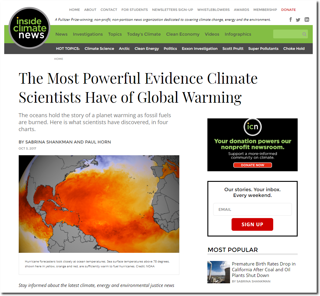
The Most Powerful Evidence Climate Scientists Have of Global Warming | InsideClimate News

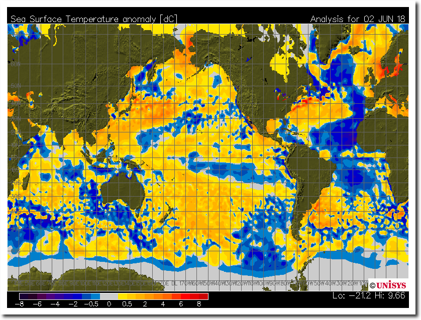
Sea surface temperatures west of Africa have plummeted and now are more than 2C below normal.

sst_anom.gif (800×600)

Climate science is populated by ignorant hacks with no understanding of science, ethics or reality – which is why Democrats and the press love them so much.

This entry was posted in Uncategorized. Bookmark the permalink.

29 Responses to Locating The Missing Cold

  1. Robertv says:

    On a 1971 – 2000 base (low CO2 cold period) world SST anomaly is just + 0,1 ºC.

    http://cci-reanalyzer.org/wx/DailySummary/#sstanom

    Only the mediterranean and baltic waters look hot because they had calm summer weather which prevented the top layer to mix with the water just under the surface.

  2. Robertv says:

    What’s the use of knowing the surface temperature but neglecting the temperature at a dept of 20 meters. Just 2 days with calm sunny weather and up they go.

    http://www.meteo.cat/wpweb/climatologia/el-clima-ara/temperatura-del-mar/

  3. John of Cloverdale, WA, Australia says:

    Here is the latest SST contour map. I don’t need reminding about not going for a swim at the start of Winter. I will wait for Summer thanks. But when I was young, I used to surf without a wetsuit. It sucks getting old.
    http://www.ospo.noaa.gov/data/sst/contour/global_small.fc.gif

    • RAH says:

      That is the third map I’ve seen showing different patterns of the current SSTs. It is the warmest also.

      • John of Cloverdale, WA, Australia says:

        The global map shown by Tony is a temperature anomaly map. The orange map above it, by Shankman & Horn, is a temperature map of the North Atlantic, from last year. Although no index on the upper map, it supposedly shows temperatures above 78 F degrees (25.56C degrees).
        BTW, I live in Perth near the coast and the water is freezing.

  4. ossqss says:

    It seems most all the Atlantic hurricane forecasts have been adjusted downward recently based upon the colder tropical Atlantic. CFAN was one of the few that called out a lower range to start out with well before this SST anomaly was detected. What did Judith’s outfit see that the others didn’t?

  5. CO2isLife says:

    The warming oceans are proof CO2 isn’t causing the warming. CO2 and LWIR between 13 and 18 microns won’t warm the oceans. Warming oceans is evidence that more visible radiation is reaching the oceans. The oceans then warm the atmosphere above it, explaining the warming of the globe. CO2 has nothing to do with it.

  6. CO2isLife says:

    Tony, I did a follow-up to this post that you may enjoy.

    The Most Powerful Evidence Climate Scientists Have of Global Warming…Rules Out CO2 as the Cause
    https://insideclimatenews.org/news/03102017/infographic-ocean-heat-powerful-climate-change-evidence-global-warming

    • garyh845 says:

      The 3 years of NASA surface temp anomaly graphic of the globe is quite intriguing, as I see 2015 as by far the warmest year and rather notable cooling into 2016 and 2017 – like a dagger right through the heart of el Nino.

  7. CO2isLife says:

    Sorry, wrong link. Here is the correct link.

    The Most Powerful Evidence Climate Scientists Have of Global Warming…Rules Out CO2 as the Cause

    https://co2islife.wordpress.com/2018/06/03/the-most-powerful-evidence-climate-scientists-have-of-global-warming-rules-out-co2-as-the-cause/

  8. Fearless says:

    The scientist that I debate climate with, AGU member, Geologist, Paleontologist, Anthropologist and who worked with Leakey in Africa, says: “… the Atlantic surface water cooling, as unscientific skeptics probably don’t realize, is due to a flood of cold fresh water emerging from the Greenland Straits as the Arctic sea ice melts down. The fresh water, being lighter than salt water, is creating a temporary layer that interrupts the normal “conveyor belt” cycle driven by the Gulf Stream.”

Leave a Reply

Your email address will not be published. Required fields are marked *