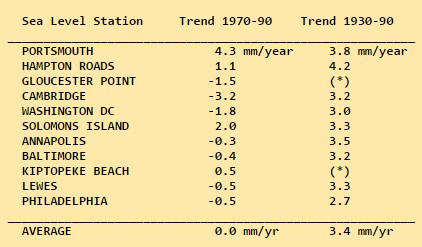
According to NOAA, sea level rise rates were much higher along the East Coast prior to 1970. In fact, there was no change in sea level along the East Coast from 1970 to 1990.
Tide gauges around the Chesapeake Bay indicate that the relative sea level in the Bay is rising at twice the average global rate of 1.8 mm per year
for now, the net change of sea level in the middle Atlantic area is zero
It is important to remember that tide gauges are primarily a navigation aid. As such, many of these tide gauges are located near ports and other growing population centers. In turn, it is possible that these sites are subject to local land subsidence caused by ground water extraction; an activity known to be increasing around the Chesapeake Bay in recent decades [Gornitz and Seeber, 1990; Holdal and Morrison, 1974]. Changes in the elevation of the land on which the tide gauges rest would also appear as a changes in the relative sea level.
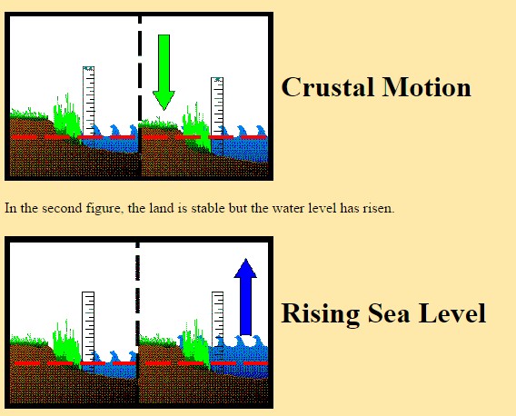
Tide gauges measure sea level changes relative to the land on which the the tide gauge rests. By itself, a tide gauge cannot tell the difference between local crustal motion and sea level changes. The following figures illustrate this point. The dashed red line is at a constant height in all figures. In the first figure, the water level is fixed but the land has fallen.


Keys officials plan meetings on sea level rise
Published: Monday, September 29, 2014 at 7:30 a.m.
Last Modified: Monday, September 29, 2014 at 7:30 a.m.
KEY WEST, Fla. (AP) — Officials in the Florida Keys are preparing for public meetings to discuss sea level rise with residents and business owners in the low-lying island chain.
Monroe County will hold a series of meetings throughout the Keys in the next several months to discuss projections for sea level rise.
The Key West Citizen reports (http://bit.ly/1DQILVQ ) that the county has documented 9 inches of sea level rise in the past 100 years. Experts hired by the county project up to 7 inches of sea level rise by 2030 and up to 24 inches by 2060.
Flooding on roads is one of the county’s top concerns. The county is compiling a list of roads, bridges, buildings and other properties that could be threatened. Several buildings have been raised to higher elevations.
http://www.heraldtribune.com/article/20140929/APN/309299887
It doesn’t matter whether the land is subsiding or not. What DOES matter is that the tide gauge data is always linear. If the land is subsiding due to geological forces, it’s going to be linear. All it does is change the slope of the line. Geological land rising and falling has nothing to do with CO2 and that’s why it doesn’t matter. In Alaska, sea level is falling due to continental rebound, but guess what? It’s linear too.
If sea levels were changing due to CO2, all the gauges in the world would show it. In fact, none of them do.
Atlantic sea-level along the northeastern U.S. coast “sloshes” slightly, in an approximately 60-year cycle, which appears to be roughly synchronized with the AMO. (There are some shorter cycles, too.) This sloshing affects coastal sea-levels by only a few inches, but within a 30 year time period the sloshing is similar in magnitude to the global eustatic sea-level change, so it can cause the appearance of a “hotspot” of significant acceleration or deceleration, depending on the periods being compared. Here are some references:
http://sealevel.info/papers.html#howlong
Note, especially, the last sentence in the highlighted paragraph, here:
http://pages.citebite.com/i3c5o5e8tyff
Dave, If Mike Stone gets elected again to the NC house you might send this info to him.
If global warming were really melting continental ice sheets, we would be witnessing the same kind of gradual, relatively uniform rise in worldwide sea levels that occurred as the last ice age ended. Minor variations (due to differences in crustal motion at different locations) would be masked; the faster the rate of sea level rise, the less pronounced the variations. The fact that these variations dominate tide gauge data today is clear and unequivocal evidence that very little additional water is being added to the oceans. This tells us two things: 1) the melting of continental glaciers has virtually ended, and 2) global warming is simply not occurring as predicted.
Charlatan, witch-doctor climastrologists point to relative rises in sea level (due to subsidence) and attribute them to anthropogenic global warming. It’s blatant fraud done intentionally to confuse sheeple. I look forward to the day when GPS data from tide gauges and nearby Continuously Operating Reference Stations (CORS) allow us to tease out variations due to crustal motions and nail down the absolute rate of global sea level rise.
Never going to happen…because then it would end a major funding stream. So, there will always be something ‘substandard’ about the system that will need to be ‘adjusted’, repaired/replaced or just plain ignored.
*Sigh*
You are correct of course.