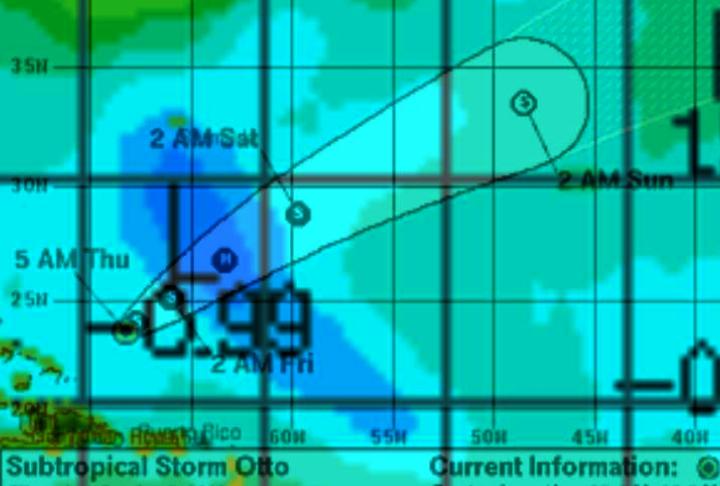
NHC is forecasting that subtropical storm Otto is going to become a hurricane tomorrow. I overlaid Otto’s projected path on top of the most recent Unisys SST map and noticed that it is headed straight for a patch of cooler water left behind by Igor. They expect it to become a hurricane after it enters the region of cooler water.
Any odds on “Hurricane” Otto’s prognosis?


Judging by the name it if it’s a cloudy breeze atmospehere at NHC right now 100% chance it will be CAT 5 Otto before the day is out…. It must be a more active than normal season now, they said so.
Hardly. SSTs are a factor in strengthening but once over 26C, they are only one of many. Shear is relaxing so the convection can build and that is the key for cyclone growth.
Narrow focus is not the same as narrow-minded.
Ya think?
I hope to see Dr. Hansimian’s forecast come true…
http://www.nationalcenter.org/HurricaneForecast.html
If Otto reaches hurricane force winds for one minute , it will be recorded by NOAA as yet another hurricane in a “string of active hurricane seasons.”
The hurricane “guys” are pretty straightforward and up-front with their errors and adjustments. No decline to hide, just errors to correct.
OTTO HAS FINALLY TRANSITIONED INTO A TROPICAL CYCLONE BASED ON A
07/0935Z AMSU VERTICAL TEMPERATURE ANALYSIS PROFILE FROM UW-CIMSS
THAT INDICATED THE WARM CORE HAD MOVED UPWARD FROM THE MID-LEVELS
TO THE UPPER-LEVELS OF THE CYCLONE. A RECENT BURST OF DEEP
CONVECTION WITH CLOUD TOP TEMPERATURES NEAR -80C THAT HAS DEVELOPED
OVER THE CENTER ALSO SUPPORTS A TRANSITION TO TROPICAL CYCLONE
STATUS. SATELLITE INTENSITY ESTIMATES ARE RUNNING BETWEEN T2.0/30
KT AND T2.5/35 KT FROM TAFB…SAB…AND UW-CIMSS USING A CURVED
BAND PATTERN. HOWEVER…USING A SHEAR PATTERN WITH THE RECENT BURST
OF CENTRAL CONVECTION YIELDS A VALUE OF T3.5/55 KT. SINCE THE
CONVECTION HAS ONLY PERSISTED FOR ABOUT 3-4 HOURS…THE INITIAL
INTENSITY WILL BE MAINTAINED AT 50 KT FOR THIS ADVISORY…BUT THE
50-KT WIND RADII DISTANCE HAS BEEN REDUCED FROM 45 NMI TO 15 NMI.