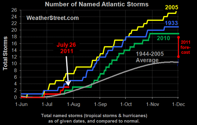
Storm namers have been naming storms at a rate 200% percent of normal this season! They are looking forward to naming another storm later today, which coincidentally will have the same name as my rock.
http://www.weatherstreet.com/hurricane/2011/Hurricane-Atlantic-2011.htm


At least all of the model tracks have it going straight to the drought in the desert….
At this rate Steve you will have to start naming pebbles, or even grains of sand! 😀
It is a bit crazy isn’t it.
Has this small storm got any chance of hitting the USA ? That is the important question !
Andy
Headed straight for Texas
As a drought-fighting Texas gardener, I hope it keeps heading our way. Most of them at that position turn westward into Mexico before hitting us.
I hate to say it but the “model consensus” has it between Corpus Christi and Galveston. Climatology is aiming for Houston but the advection models want Brownsville.
NOAA recon will be in the area this p.m. so they will have a better idea of what’s what shortly.
Maybe this will help…
http://www.youtube.com/watch?v=5MJLi5_dyn0
The meteorologists (sane, rational, interested in facts, climate-folk) like this year for US landfalls more than an excessive number of storms.
Climatology (the average of past years kind) indicates that the ramp-up in named cyclones starts around August 15 and recedes around October 15.
Hopefully not too many majors will make landfall and cause excessive damage. Preparation is the key to mitigation because you can only get out of the way…
I guess they are including Donny – they were calling him before he was even formed. But 3 “pffts” and now Donny? I doubt the ACE is above average.
Ya, global ACE index is still in the dumper. Even when you get fish storms like Bertha that lasted 58 days, as cat1 or a TS, the ACE is really affected by those majors that last more than a couple of days.
If Don is just a nice rain event for Texas then all the better.
http://tropicalatlantic.com/recon/ then click on live recon on google earth, to see what the plane is flying through as it measures windspeed and other factors.
Looks like a likely full tropical storm or just barely a cat 1 at landfall.
The hurricane center is salivating to name Don. In their own statement, they said they would start putting advisories out if there was any sign of circulation. Circulation does not mean it’s a tropical storm or even a depression. These people are loons.
Another example of the “nudge principle” applied in the field of weather and climatology.
They clocked their air speed at 250 MPH and named that large cloud Don! They expect it to do something over the next few days. It is giving the folks at Accuweather tingles running up their legs and they appear to be salivating all over.
There is a system in the midwest larger than Don and they did not even name it!