You just can’t make up stupid like “climate experts”
Water is a low viscosity fluid, so it rapidly seeks a common level across all connected bodies.
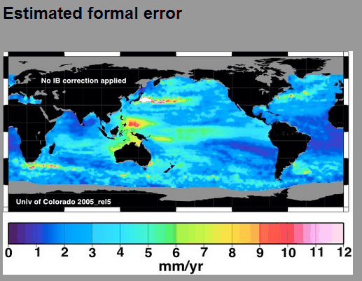
The measurement error near the Philippines is almost 9mm/year, making the signal to noise ratio close to zero.


Reblogged this on Defy The Narrative.
This is why they are now refusing to debate deniers.
Unlike water, wisdom is a highly viscous fluid. It mounds in some people and avoids liberal zombies.
Steven is showing his ignorance once again … how could there be water skiing if the water wasn’t mounded up into hills!!
(do I need a sarc tag?)
See, the power boat artificially tilts the gravity field so that forward becomes downward. That’s the hill the skier is descending!
/semi-humorous
Question regarding sea level measurements: Given that the Philippines is seismically very active , how are levels adjusted to account for movements in land?
It is actually pretty simple. First, you just assume that seal level is rising in the Philippines at a rate of 10 or 12 mm per year. Then you read a tide gauge. Suppose the gauge says 1 mm rise per year. Subtract 12 and there’s your answer! The Philippines must be sinking at 11 mm per year.
Gosh! Look at me! I am doing CLIMATE SCIENCE!
🙂
Typo — seal = sea.
Interesting though…
The Seal Evil is rising. I, for one, welcome our pinniped overlords.
Seal Evil! LOL! I have a hard time imagining how “our pinniped overlords” could do a worse job than what we have had for the last several decades… 🙂
You’re all barking.
An example to my previous post:
https://anc.yahoo.com/video/strong-quake-causes-maribojoc-coastline-200238264.html
I wonder, is “formal error”, one sigma, or 95% confidence, or what? Anyone know? Thanks.
Apparently it wasn’t an iceberg that caused the demise of the Titanic, it was a localized sea level rise.
No, it was a local boat level lowering.
Steve, James and I looked into this….a lot
It’s an artifact of two things…..undersea volcanoes and mountains that have higher gravity…pulling the satellites down, and holding higher water on top of them
..and satellites that are “tuned” to convenient land based tide gauges…where they pass over frequently….that show sea level rise
But we are looking at an alleged anomalous and rapid change in sea level over quite an area near the Philippines. The rapid rate implies a rapid change in gravitational anomaly in this area. And while this is a seismic area, I don’t think we are seeing such changes as would explain the rapid local sea level rise shown. Short term phenomena such as tides, barometric pressure and winds can change sea level significantly for short durations but the areas of rapid sea level rise over longer terms as shown in the sea level rise map hint at errors / artifacts of the measurement and modeling process. In other words, they are a red flag for a flawed sea level measurement process. If sea level rise was primarily a result of accelerated glacial melt, one would expect a valid measurement of the rate of sea level rise to be almost uniform over the globe.
Actually, there is no such thing as sea “level” because the surface of the sea conforms to the shape of the Geoid :
http://en.wikipedia.org/wiki/Geoid
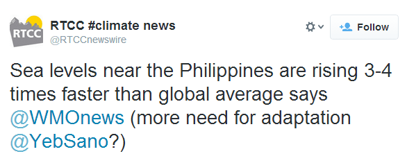
It may well be true the sea surface around the Philippines is rising 3-4 times than the global average, but the big lie (by implication) is that this is somehow connected to climate change. That’s bollocks.
The more probable explanation is that it is due to changes in gravity anomalies in what is, as HILN pointed out, an area which is seismically very active.
I like this video “what is sea level”
https://www.youtube.com/watch?v=q65O3qA0-n4
Perhaps east of the Philippines, water is upwelling from the mantle, which contains vast amounts of water. See
http://news.yahoo.com/brazilian-diamond-hints-vast-water-deep-inside-earth-171046792.html
Over the last 10 thousand years, there is no correlation between atmospheric temperature and sea level rise. The entirety of sea level rise may simply be new water added to the oceans from the mantle. Climate scientists have not even considered this possibility.
http://journals.ametsoc.org/doi/abs/10.1175/JCLI-D-13-00276.1
The plate must be rising, earthquake time soon
In my understanding of the tropical Pacific, it is possible for water to “mound up” on one end, and I think is very common in strong El Nino and La Nina years. Prevailing winds and differences in atmospheric pressure an apparently account for such mounding up of a few millimeters.
Waves (temperorary sea mounds) must really freak alarmists out.
They’d go into meltdown every time they went to the beach.
Of course, that’s a temporary effect, not one you would “adapt” to.
And needless to say the Philippines gets hit by massive hurricanes all the freaking time anyway, they’re hardly going to notice a few mm. My wife is from Luzon, she laughs at our “storm warnings” here in the Midwest (course, she hasn’t seen a tornado yet!).
ERRRrrrr, I thought Bob Tisdale had don a lot of work on ENSO and found that due to the trade winds the water is literally blown towards the Indian Ocean during El Niño and then ‘sloshes back’ during La Niña when the winds are not as strong. So how high the eastern Pacific is compared to the western Pacific depends on whether it is El Niño or La Niña or like right now in neutral.
El Niño and La Niña Basics: Introduction to the Pacific Trade Winds
http://bobtisdale.wordpress.com/2014/02/22/el-nino-and-la-nina-basics-introduction-to-the-pacific-trade-winds/
Looking at the pattern of rises, (including the rise in sea level just east of New England), that sounds like a very plausible explanation for a large part.
It does not have to be either local seismic OR wind; it can certainly be a combination of multiple factors. Wind, thermal expansion, seismic activity, localized gravitational irregularities, variations in salinity (and hence in density), lunar induced changes in current and tidal patterns, etc.
By the way, Gail… off topic and all, but I am always surprised and impressed by some of the topics and links you come up with. You are a bright and sparky person.
Yes. I am surprised there is no link with her name to a blog or website. There is a lot of research she has done which could be used by others fighting against the Warmist religion takeover attempt. Much of it could also serve as a basis for discussion on a blog.
I am ‘Computer challenged’ I know just enough to get into trouble. Hubby is the guy with the computer expertise. He used to write computer manuals.
I have been one of the top commenters on WUWT for the last couple of years and I comment on other blogs and news media too as well as talk with people in person. (I think I managed to drag WUWT as a group into realizing that CAGW was a political hoax but it took a few years.)
I figure every little bit helps.
Thanks.
I am hoping to get information out that people can use. I very much do not like the where the USA is headed.
I hope that big ol’ mound of water doesn’t tip Guam over. 😀
Lots of possible reasons. The crust of the earth is an egg shell over a very thick mantel. A moving mantel of disparate density due to it temperature, and deeper earth processes. Who is to say how this affects gravitational anomalies.
Or the earth’s magnetic field.