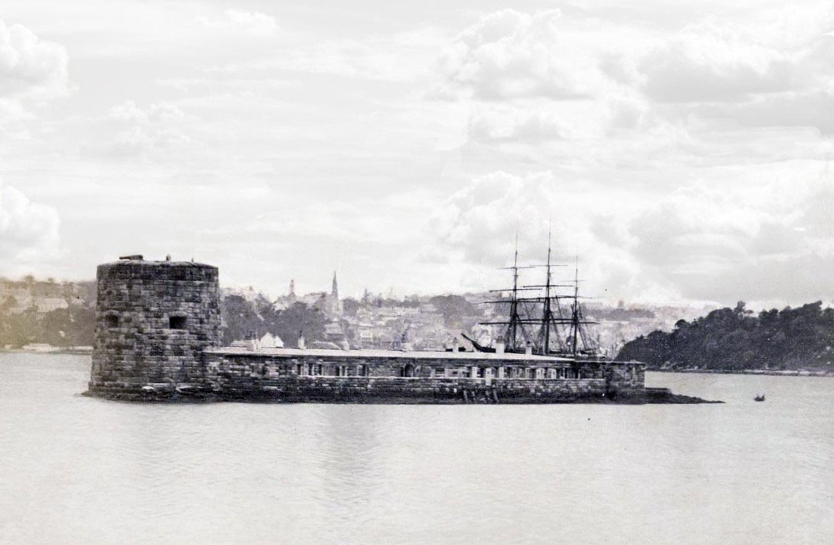
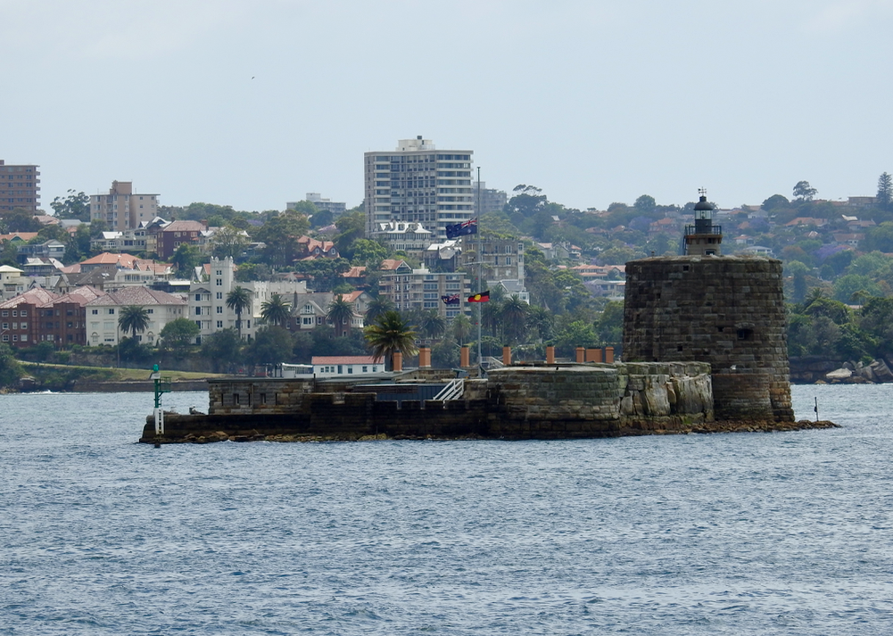
The overall rate of sea level rise at Fort Denison has been 1.0 mm/yr since 1915. For the last 30 years the rate has been 1.8 mm/yr. The 30 year rate has been as high as 2.2 mm/yr for the 30 year period ending in 1968, and the rate over a 30 year time series has been negative -0.3 mm/yr as recently as 2000.
Steve, It is quite likely that the slightly higher rate was due to subsidence and erosion of the foundation sandstone
I forget which year it was, but not that long ago they did extensive remedial work to fix the problem.
I also seem to recall a surveying study done around 2005-2010 (quoting from memory) that showed Fort Denison was actually rising at something like 0.45mm/year compared to some other parts of Sydney.. I can’t find the reference.
Tide gauge sites in Australia are surveyed every few years. Never heard of CGPS? There are 1000s of stations worldwide. There’s a station on Fort Denison that shows a 0.15mm/year drop over 10 years to 1914. That’s considered stable. Hillarys N of Perth is dropping at 2.78mm/year. Variation in SL change around Australia is largely driven by longer-term PDO and shorter-term ENSO. On the W and N coasts it’s almost entirely driven by those cycles.
Just sailed by Fort Dennison a few days ago and will again on the 26th to watch the start of the Sydney Hobart Yacht Race as well as on the 31st to watch the incredible fireworks here in Sydney Harbor.
Looks just the same today as it did in the pre 1885 photo Tony shows except today it’s a tourist attraction.
California is another place where the popular press tells us that there’s a looming sea level crisis coming when anyone who takes the time to examine the empirical record provided by the state’s tide gauges will soon figure out that the so-called popular press isn’t telling the truth.
Yes. Plus anyone that’s old enough and seen the beaches several decades ago knows that the beach and sea is just the same. It was just the same 40 years ago, and apparently it was just the same 140 years ago too.
Meanwhile, that picture was taken of a place where all of us flyover folks would just as soon see a smooth unbroken sea for multiple miles in any direction.
The 15th of December 2016 here on Moreton Bay in SE Qld, Australia, was the highest tide of summer and guess where this king tide came to relative to where those fine weather king tides [~ normal BP] came to in 1946, 70 years ago?
A foot lower!
I have been checking our family’s old sea front property, where I spent a lot of time between 1946 and 1953, for the last 6 years and that has been the constant story. The local tide gauge does not have a continuous record but tide gauges will show SLR if only low tides are increasing which can happen through changes in hydrodynamics whereas the only true SLR is the tops of the normal BP king tides.
The bay near our old property has not been affected by any ocean hydrodynamics other than dredging of sandbanks [which could account for it if you subscribe to the trick of lowering the river instead of raising the bridge ].
First bridge I ever saw that ended in the middle of a body of water, on purpose. And that’s the first tunnel I have ever seen that originated in a body of water. :)
The overall rate of sea level rise at Fort Denison has been 1.0 mm/yr since 1915. For the last 30 years the rate has been 1.8 mm/yr. The 30 year rate has been as high as 2.2 mm/yr for the 30 year period ending in 1968, and the rate over a 30 year time series has been negative -0.3 mm/yr as recently as 2000.
Source
http://www.psmsl.org/data/obtaining/stations/196.php
But I’m sure the usual crowd is telling folks in Sydney to expect way more than 83 mm of sea level rise by 2100. I’ll have to look it up.
After a short search:
The Sydney airport will be at a high risk of flooding.
The elevation at the Sydney airport is 30 feet.
The lies and bullshit from the “main stream” media is never ending.
Where did you get 30 feet from? Elevation at the southern end of runway 34R is 1 to 2 metres. 5-6m around the main buildings to the N.
Steve, It is quite likely that the slightly higher rate was due to subsidence and erosion of the foundation sandstone
I forget which year it was, but not that long ago they did extensive remedial work to fix the problem.
I also seem to recall a surveying study done around 2005-2010 (quoting from memory) that showed Fort Denison was actually rising at something like 0.45mm/year compared to some other parts of Sydney.. I can’t find the reference.
Tide gauge sites in Australia are surveyed every few years. Never heard of CGPS? There are 1000s of stations worldwide. There’s a station on Fort Denison that shows a 0.15mm/year drop over 10 years to 1914. That’s considered stable. Hillarys N of Perth is dropping at 2.78mm/year. Variation in SL change around Australia is largely driven by longer-term PDO and shorter-term ENSO. On the W and N coasts it’s almost entirely driven by those cycles.
That’s wrong.. It was SINKING at 0.45mm/year.
hence the real harbour level rise was around 0.2mm/year.
But it’s flipped 180 degrees, giving credence to the fear that Guam may tip over!
:–))
I think in fact that Guam did actually tip over so much that it is now in its original position. Boy we survived that one!
According to NOAA the trend at Fort Dennison is 0.65mm per year +/- 0.10mm.
https://tidesandcurrents.noaa.gov/sltrends/sltrends_global_station.htm?stnid=680-140
I’ve sent a lot of my friends to this page to prove a point.
Yep. 0.65mm/year, according to NOAA.
PANIC !
Buy Floaties !!!!!!
At least they can celebrate Christmas in summer.
This afternoon we leave for the Netherlands to be with my parents . A 1500 km drive mostly in the dark. Weather conditions don’t seem to bad.
http://www.vigilance-meteo.fr/en/weather/weather-for-professionals/clouds-precipitation-film/france.html
bon Nadal/fijne Kerstdagen to all of you.
Just sailed by Fort Dennison a few days ago and will again on the 26th to watch the start of the Sydney Hobart Yacht Race as well as on the 31st to watch the incredible fireworks here in Sydney Harbor.
Looks just the same today as it did in the pre 1885 photo Tony shows except today it’s a tourist attraction.
Here’s the Wiki on it:
https://en.wikipedia.org/wiki/Fort_Denison
Must have been one massively thick ice sheet there for there to be so much post-glacial rebound… ;p
And isn’t it amazing how that rebound so exactly matches the massive sea level rise since Trump was elected…. and Britex… and….
La Jolla CA 1871 is the same also (as is most of the world!):
California is another place where the popular press tells us that there’s a looming sea level crisis coming when anyone who takes the time to examine the empirical record provided by the state’s tide gauges will soon figure out that the so-called popular press isn’t telling the truth.
Yes. Plus anyone that’s old enough and seen the beaches several decades ago knows that the beach and sea is just the same. It was just the same 40 years ago, and apparently it was just the same 140 years ago too.
So no hope of drowning dems anytime soon huh…
Great gif btw..
Not without the big one or a tsunami. .
Meanwhile, that picture was taken of a place where all of us flyover folks would just as soon see a smooth unbroken sea for multiple miles in any direction.
Clearly they raised the island to counter the effects of the rising water.
The 15th of December 2016 here on Moreton Bay in SE Qld, Australia, was the highest tide of summer and guess where this king tide came to relative to where those fine weather king tides [~ normal BP] came to in 1946, 70 years ago?
A foot lower!
I have been checking our family’s old sea front property, where I spent a lot of time between 1946 and 1953, for the last 6 years and that has been the constant story. The local tide gauge does not have a continuous record but tide gauges will show SLR if only low tides are increasing which can happen through changes in hydrodynamics whereas the only true SLR is the tops of the normal BP king tides.
The bay near our old property has not been affected by any ocean hydrodynamics other than dredging of sandbanks [which could account for it if you subscribe to the trick of lowering the river instead of raising the bridge ].
An entrance to a tunnel between Denmark and Sweden, they don’t appear to be worried about sea level rise.
WOW.. that is some serious bit of engineering !!!
Øresund Bridge. if anyone wants to look further.
And another one planned between Denmark and Germany
http://www.bbc.com/news/world-europe-33633879
I guarantee some numb nut is going to point out that already half of the bridge is underwater.
Pingback: Terrifying Sea Level Rise At Sydney — The Deplorable Climate Science Blog | libertariantranslator
First bridge I ever saw that ended in the middle of a body of water, on purpose. And that’s the first tunnel I have ever seen that originated in a body of water. :)
Check out the Chesapeake Bridge Tunnel! same kinda thing