Whoever undertakes to set himself up as a judge of Truth and Knowledge is shipwrecked by the laughter of the gods.
– Albert Einstein
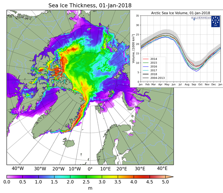
The Northern Sea Route passes from the North Sea to the Pacific Ocean along the coast of Russia.
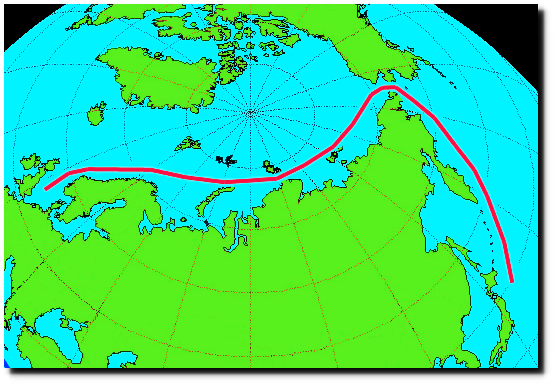
It is now blocked with 3+ meter (10 feet) thick sea ice, shown as yellow and red in the map below from the Danish Meteorological Institute (DMI.)
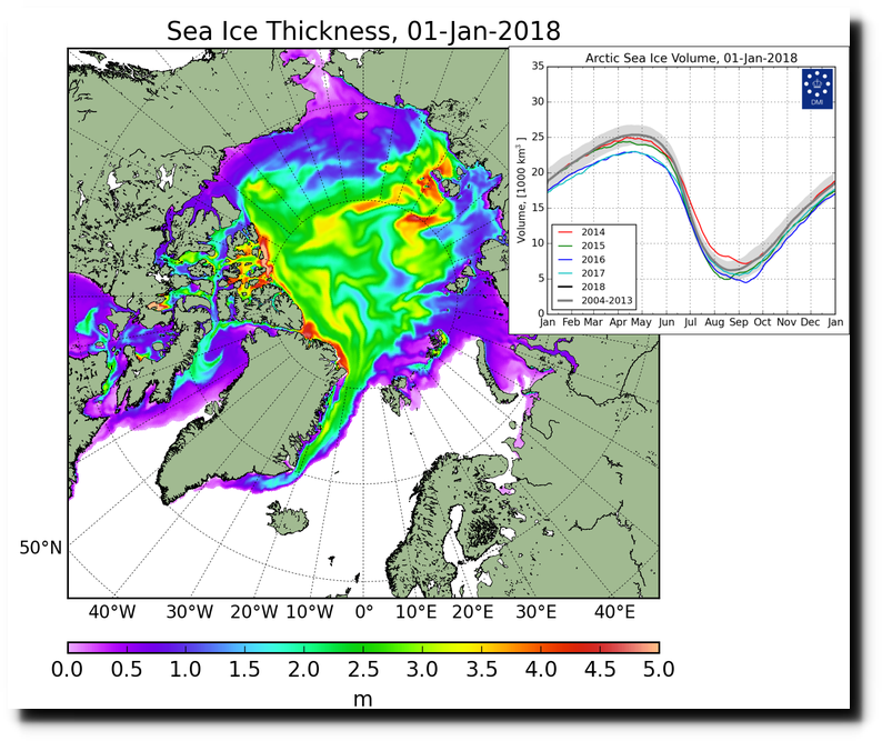
CICE_combine_thick_SM_EN_20180101.png (758×631)
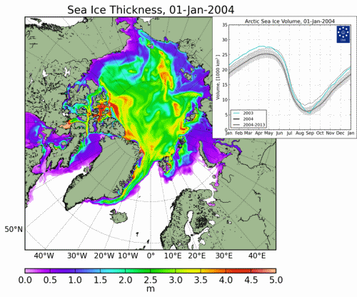
DMI has records for 15 years, going back to 2004. The only other year out of the last fifteen which had ice this thick blocking the Northern Passage was 2010. But 2010 was less problematic because the thick ice was at lower latitude where the ice normally melts during the summer. The animation below shows all 15 years.
Russia is building three nuclear ice breakers to allow commerce through this ten foot thick ice. Good luck with that!
TASS: Military & Defense – Russia to build 3 next generation nuclear-powered icebreakers by 2025
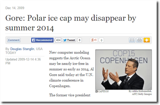
Meanwhile, US scientists who are desperate for global warming funding, simply pretend the ice isn’t there. Al Gore won the Nobel Prize for lying about the Arctic.
In 1944, Larsen sailed the NWP in a boat, the St Roch, with the hull hardened with Aussie ironbark through the passage next to Banks Island. With its tiny motor, it was capable of something like 4 knots.
No-one has ever sail that route since, its been impassable.
All NWP passage trips have been through the southern route through the lower part of Cambridge Bay.
The NorthAbout, a specially designed aluminium hulled lightweight boat, had satellite weather and ice location help, drones, ice breaker assistance, and was capable of 26knots (iirc) with it extra outboard motors helping its main engine, and still only just made it through the Cambridge Bay route.
The Northabout managed to sneak under motor power between the ice and the shoreline with their retractable keel pulled up. The narrow passage opened up briefly and closed after them again.
They were
lucky… что я американский дурак говорю … they were clever.The St Roch became the first vessel to navigate the NWP in both directions between 1940 – 1944.
The first voyage (red) used the southern route and took around 18 months. However, the return voyage (blue) used the most northern route and was completed in 86 days – port to port – in doing so, it became the first vessel to navigate the NWP in a single season.
Russia is broke! The low oil prices, and corruption have been hitting them hard just as they have Iran. I laugh when I see articles claiming the Russian military is a real threat. They simply don’t have the money to sustain an up to date and well trained Army even 1/4th the size of what they had when the Berlin came down. They have only about 20% of the defense industry they had in the 80s and have a hard time keeping the expertise to even keep what they’ve got going because their best can go elsewhere and make more money. Don’t buy the hype. Russia has real problems and they are getting worse every year.
N0t worried about their military, they are only a threat to local smaller countries that don’t want to behave as Russia would like them to…..
… but they are the only country capable of keeping the Arctic route even partially open.
Yet they are so super-advanced in electronic communications that for just $100,000 worth of Facebook ads they overwhelmed Clinton’s $1, 500,000,000+ ad spending.
Russian hackers that helped Trump !!
Or was it Hillary !
Good one AndyG55.
That’s the thing about those sneaky Russians. Who would guess that those four are actually highly skilled hackers… and yet they are. The caption says so.
The BENEFITS, if the Russian Coast route was open for even a few extra weeks a year, would be ENORMOUS !!
Unfortunately, once the jet stream settles down, there is going to less and less “open” time.
The Russians know this and are currently building some of the most powerful Ice Breakers even built, with nuclear power plants actually able to melt their way through the ice. !
Based on the Russian history with nuclear power, both on the sea and ashore, I sure wouldn’t want to be in the crew.
As good list of world IceBreakers.
Bold are current in service. (starts at Argentine scroll down for others)
https://en.wikipedia.org/wiki/List_of_icebreakers#Argentina
ps, when you get to the Russian section, you will see why Russia rules the Arctic seas..
Well we now know why they purchased 20% of Wyoming’s known uranium reserves. Oh they are also building other nuclear powered ships.
How does that 12 million square miles of 10 foot thick sea ice figure into the overall average sea surface temperature of Earth?
I know. 71% of the Earth is ocean surface. +/-192,000,000 x 71% = 136,320,000 (ocean surface) – 12,000,000 (Arctic Ice surface) = 136,308,000 square miles to get an accurate global average temperature record.
I really doubt that an overall change in our overall atmospheric make-up of 0.012% over the past 350 years is really going to have any real, substantive, or even dramatic affect on 9% of Earth’s ocean surface.
Was my math right on this?
Anyone? (Thanks! … in advance.)
The Russians were going to offer the NSR up for world shipping in 1967. A political crisis put paid to that and the offer was not made formal until 1987.
The russians have ports and communities along that long stretch of shore, so they need to supply them, and they have not baught the disappearing ice meme, because they look at the real conditions. There might even be oil and gas there. Why let it seep up unused?
Not just Arctic Ice that is defying Al Gore logic just look at the growing ice coverage compared to historical ice coverage for the Great Lakes for this time of year.
http://iceweb1.cis.ec.gc.ca/Prod/page3.xhtml
Is this the chart you mean?
AndyG55 could you provide a link to the source? I’ve got someone I want to send it to.
Hi Rah, only just saw this message.
Direct link won’t work. (even the one I bookmarked doesn’t)
You have to go back to page 1 of the link given by northernont and battle your way through to find the Great Lakes graph.
Thanks Andy. NOAA GLCFS is up again.
https://www.glerl.noaa.gov//res/glcfs/glcfs.php?hr=00&ext=ice&type=N&lake=l
This site by the U.S. Navy giving arctic ice depth seems to show mostly just 1.5 meter and less thick ice:
https://www7320.nrlssc.navy.mil/GLBhycomcice1-12/navo/arcticictn/nowcast/ictn2018010212_2018010300_929_arcticictn.001.gif
From data on this page:
https://www7320.nrlssc.navy.mil/GLBhycomcice1-12/navo/arc_list_arcticictn.html
While the Danish Meteorological Institute site shows abundant 3 meter thick ice.
Any idea what is the explanation of the discrepancy?
Bob Clark
The Navy changed their charts a couple of months ago, making the ice much thinner. The new charts makes no sense.
They both use the HYCOM+CICE model so I don’t get why they would be different. Perhaps the grayish area in the Navy graphic represents 2.75 m, not 1.5 m?
Do you have a link to the older Navy graphic?
Bob Clark
Wonder if they have a special version just for their use. I mean it is kind of important that their officers have as accurate of information as possible for planning and operational purposes.
Perhaps they changed it to show just that portion above water level ;-)
It should be possible to computationally assign numerical RGB values to the colors in the color bar on the right. And then determine which color, and therefore which ice depth, is represented by the darkish, grayish areas in the graphic.
Bob Clark
I used an image analysis program to determine the U.S. Navy graphic is indeed showing most areas as only 1.5 meters thick ice and less.
But in addition to the Danish Meteorological Institute site showing abundant 3 meter ice, this site using data from the Cryosat-2 satellite also shows large amounts of 3 meter thick ice:
http://www.cpom.ucl.ac.uk/csopr/seaice.html
So what is the source of the discrepancy? The idea that Arctic ice is diminishing to dangerous levels is probably coming from the data on the U.S. Nay site.
So it is important to know which one is right.
Bob Clark
It really isn’t that important in a practical sense except for those that must navigate or make their living up there. For the climate argument it’s only relevance is that the ever changing sea ice is a climate “canary in the coal mine” according to “the consensus”. But as far as CAGW goes, melting sea ice does not increase the rate of SLR and there is absolutely no evidence that the claims that it will cause a drastic change in ocean currents are accurate. So in the end all of this argument comes down to people arguing a point based on a false premise.
The Navy has lost all credibility because they just buy into climate change completely. It should know better.
“IF ” as we are being told that the Arctic was becoming Ice free, “WHY ” then don’t we see the Cargo Ships using the “SO CALLED “North West Passage “INSTEAD ” of the “EXPENSIVE, LONGER ” Panama Canal? We are being LIED to BIGTIME.
When I looked into it I found only three instances of cargo ships successfully using the NWP. I also believe that if it were true that Arctic ice was melting more than it usually does, that there would be more cargo traffic through there. But when it comes down to real dollars, the shipping industry is not as easily fooled as the CAGW crowd.
That has to do with the fact that those in the shipping industry who get easily fooled are no longer in the shipping industry.
The CAGW industry and its backers have different rules. Regardless how many times you show yourself to be a zealous moron, you will not be excluded. On the contrary, it will enhance your status, reputation and pay.
This discusses some eloquent considerations-but I notice you could be in need of detail. I want to see you elaborate, because you are a good writer and I like reading your posts.