And the tripod still stands at Nenana, Alaska. Nighttime temperatures have still been dropping below freezing at night so the surface water re-freezes by morning. If the tripod stands after 11:24 on May 20th, it is a new record late ice out for Nenana.
It snowed 11.5″ from late yesterday to this afternoon here in the Upper Copper River Basin. A NOAA meteorologist says that if this coming Friday’s/Saturday’s pattern holds (cool air & low to the south), we may see another batch of snow up to 12″…
Steve – We had enough migrating birds die up here today, to feed a small nation.
With the ground covered, 28 degrees and snow, they are fighting for their lives, including white crowned sparrows, Lapland longspurs, junckos, pine siskins, pine grosbeaks, boreal & white capped chickadees (though they are tough) among many others…
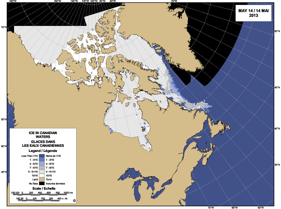
I often see this map on the sea ice page over at WUWT. I don’t understand how the ice is shown as thicker amongst the islands than it is further North. This doesn’t seem to tally with the other ice maps that are available. Any ideas?


And the tripod still stands at Nenana, Alaska. Nighttime temperatures have still been dropping below freezing at night so the surface water re-freezes by morning. If the tripod stands after 11:24 on May 20th, it is a new record late ice out for Nenana.
Sorry, link for above: http://www.nenanaakiceclassic.com/
I’m guessing 5-19-13 at 6:26 AM, if its any later than that I lose again ($318K)…
It snowed 11.5″ from late yesterday to this afternoon here in the Upper Copper River Basin. A NOAA meteorologist says that if this coming Friday’s/Saturday’s pattern holds (cool air & low to the south), we may see another batch of snow up to 12″…
Alaska is the fastest warming place on Earth. I read it in National Geographic.
They probably should have stuck with pictures of topless Tahitian women.
Those of us that got our indoor gardens started in April find ourselves transplanting, still indoors:)
Steve – We had enough migrating birds die up here today, to feed a small nation.
With the ground covered, 28 degrees and snow, they are fighting for their lives, including white crowned sparrows, Lapland longspurs, junckos, pine siskins, pine grosbeaks, boreal & white capped chickadees (though they are tough) among many others…
http://www.youtube.com/watch?v=icAwcByaNtY
Sweet!
That’s the pacific Princess, which I got a tour of in Mazatlan in the early 80’s, but not by Gavin:)
It appears if you want to cruise the NW Passage. It might be safer booking a bunk on a USN Submarine and go under the ice. 🙂
I often see this map on the sea ice page over at WUWT. I don’t understand how the ice is shown as thicker amongst the islands than it is further North. This doesn’t seem to tally with the other ice maps that are available. Any ideas?
It isn’t thickness, it is concentration. The ice can’t blow around much in constrained areas.
Sure, but other maps eg Naval Research Laboratory, show 100% and as it looks like it’s over 15ft thick it would be suprising if it was anything less.