A few weeks ago climate scientists said climate change is making hurricanes slow down, stall and rain a lot like Florence. This week they say climate change causes fast moving hurricanes like Michael.
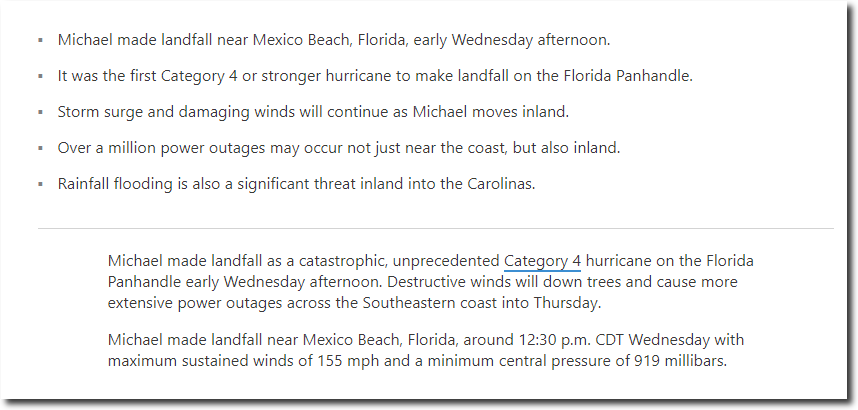
I was watching the storm and the commentary this morning, and long before landfall Michael was officially declared to be a catastrophic category four hurricane (just below category five), the most powerful to ever make landfall “in that region” – and the third most intense in US history after the 1935 Labor Day hurricane and Camille in 1969. It was a genuine pre-hurricane category four propaganda storm.
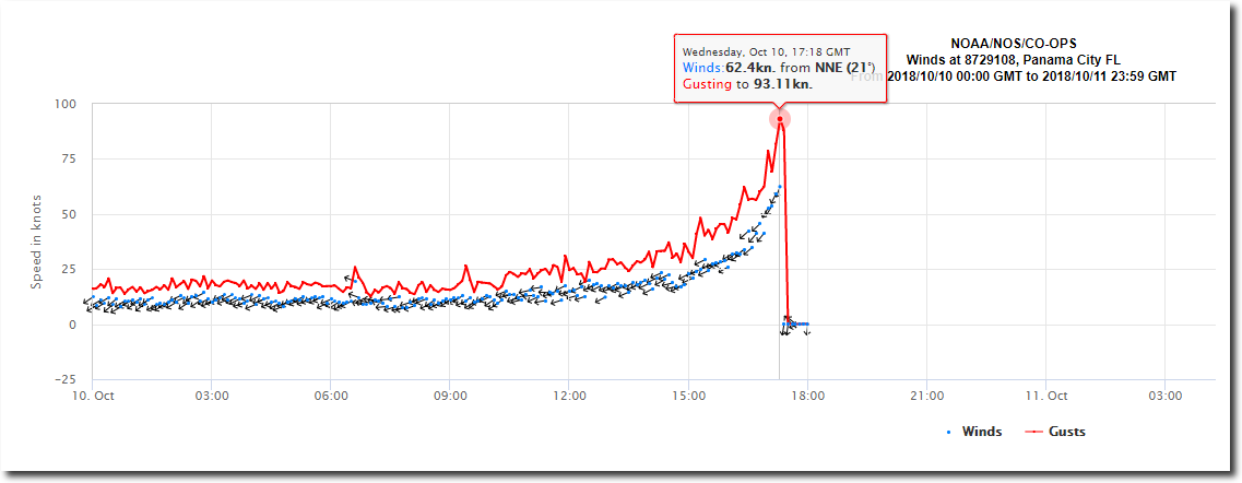
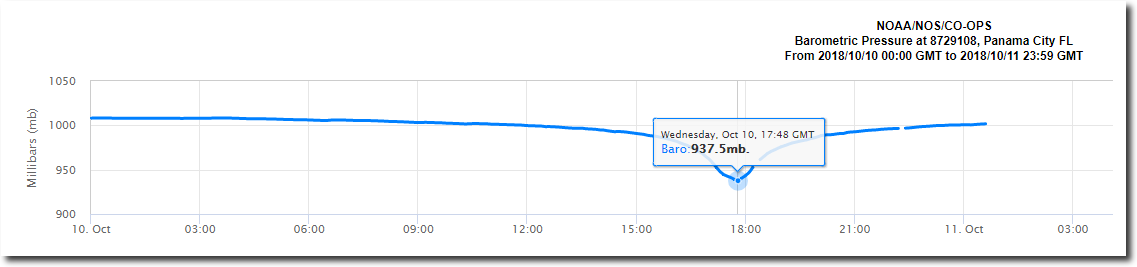
The NOAA wind gauge at Panama City didn’t back up any of the claims. It showed a peak sustained wind speed of 62 knots before the eyewall arrived, and minimum pressure of 937.5 mb. Neither remotely close to the hype.
Meteorological Observations – NOAA Tides & Currents
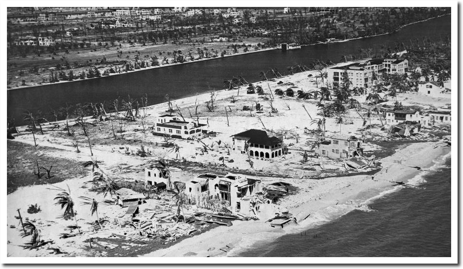
The pictures of damage I’ve seen don’t compare to other “officially less intense” hurricanes, like Andrew in 1992.
Or the 1926 Miami hurricane.
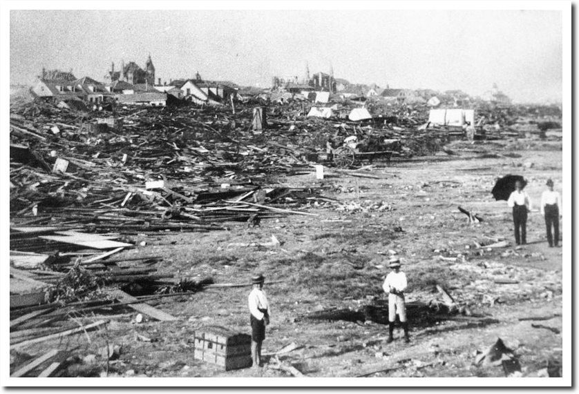
Or the 1900 Galveston hurricane.
Weather Channel made these claims – 155 MPH sustained winds and central pressure of 919 mb. which weren’t even in the ball park of what the NOAA instrumentation at Panama City showed.
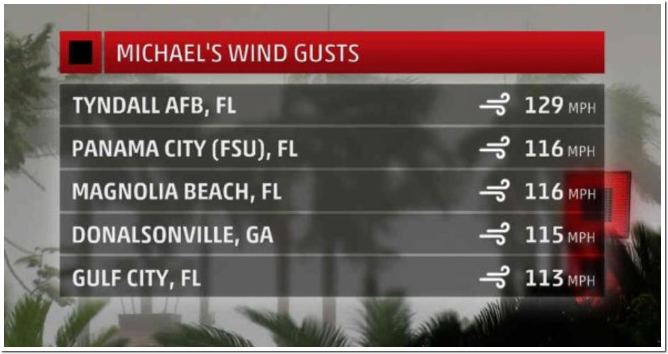
And then they directly contradicted themselves in the same article, with the image below. There weren’t any category four wind speed gusts, much less sustained winds. I don’t see any evidence from wind reports or damage reports that Michael was a category four storm at landfall.
I also don’t see any evidence that Michael was stronger than numerous other hurricanes which have hit the region.
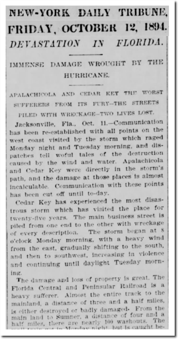
12 Oct 1894, Page 7 – New-York Tribune at Newspapers.com
I’ve seen this pattern over and over again – fake landfall statistics are made up long before landfall, the press dutifully parrots them, and then the actual data measured at landfall becomes irrelevant. It is same strategy leftists use for everything.
I agree that as has been the norm, Michael has been hyped beyond what it really was. Thankfully, it appears from the real data that the storm was not a Cat 4 hurricane.
This official NOAA Panama City coastal station, https://www.ndbc.noaa.gov/images/stations/pcbf1.jpg , https://uploads.disquscdn.com/images/c7773e46b15321267a4160187c5a46920b83be25bfc9a0799867ea0c4b3ecb12.png , recorded a maximum sustained wind speed of 53.0 knots, which is 61 mph, which isn’t even Cat 1 windspeed. Here are screen captures of the station data during the maximum recorded wind speeds: https://uploads.disquscdn.com/images/6e27cb15d7d36907f76c4f3065fd8d21c4f5fc84f6ad81a6c3781db63765284a.png
Note the maximum 53.0 knots (61 mph) at 3:06 pm.
The nearest NOAA buoy to the east of Panama City, APCF1, recorded a maximum sustained wind speed of 54.0 knots (62 mph), which is also not even a Cat 1 hurricane. Here is that station: https://www.ndbc.noaa.gov/station_page.php?station=apcf1
Here is a screen capture of the wind speeds recorded during Michael’s landfall: https://uploads.disquscdn.com/images/326b1c9af4e01c28f2e9cb993c8047d2c01da8b3b95a4ea26e9e73b39bd05ddd.png
Note the maximum sustained winds of 54.0 knots (62 mph) at 1:06pm.
Here is the closest NOAA station, SGOF1 , to the east of Panama CIty which is out in the Gulf, unaffected by land, https://www.ndbc.noaa.gov/station_page.php?station=sgof1
This wind speed measurement is at 35.1m above surface, which would measure higher windspeeds than the official 10m height.
Here is a screen capture of the max wind speed history of station SGOF1: https://uploads.disquscdn.com/images/33c575eeac8f491f600fa4a3d2525aa130374cc28fdaee20ed7749a5f340ea9e.png
Max sustained wind speed of 61 knots (70mph) between 11an and noon.
Here is the wind speed history at a Panama City Beach weather station: https://uploads.disquscdn.com/images/490679e6111aad721b1ae3d686ef11958faccaef1a8c13f3703e58a5ed49c6a2.png
Maximum wind speeds of between 70mph and 75mph.
Here is another wind speed history at Panama City Beach: https://uploads.disquscdn.com/images/d0c67684db3570bc8b7c68734886635a93e0cbec4071a250fa50668bce83f6a2.png
Maximum wind speed of 76.1mph, barely Cat 1.
This actual data seems to indicate that Michael was hyped beyond what it really was.
So where is the hard wind speed data confirming that Michael made landfall with Cat 4 windspeeds of greater than 130mph to 153mph???
Can anyone link to any hard wind speed data confirming Cat 4 windspeeds? Not just reports, but actual documented DATA?
https://www.nhc.noaa.gov/archive/2018/al14/al142018.update.10101853.shtml?
“Recently reported wind gusts include:
Tyndall Air Force Base: 119 mph (191 km/h)
Florida State University Panama City Campus: 116 mph (187 km/h)
University of Florida/Weatherflow Mexico Beach: 104 mph (167 km/h)”
The differences make sense, since Tyndall is right in the firing line, however in the summary:
“MAXIMUM SUSTAINED WINDS…150 MPH”
I guess that must be historical, somewhere out where it would affect only boats and seagulls. Incidentally your original link:
https://tidesandcurrents.noaa.gov/met.html?id=8729210
Now reads maximum gusts of 76kn and sustained of a “terrifying” 42kn
Andrew was a compact category 5 storm. Winds alone were house flatening and it was that hurricane which prompted new building codes for the state. Michael is a larger less thightly wound storm without the wind speeds of Andrew.
So every time a really bad storm occurs, building codes are made stricter, meaning the same storm 20 years later will do less damage. So for the same damage to occur 20 years laster, the storm has to be worse than the prior one.
Because mobile home parks are very well engineered, and 2×4 construction of brick houses is somehow different from the 19th century.
The primary change to the code made after Andrew as I recall was to require galvanized sheet metal brackets to reinforce the attachment of rafters to walls to help prevent the whole roof being blown off the home. However if your standard stusk construction place took a direct hit from the eyewall of Andrew it would be gone down to the slab foundation. Andrew was like a giant EF-4 tornado. No standard construction building is going to stand up to a direct hit from winds like that.
Rafter tie downs have been SOP in California since 1950. Detailed wind studies (including uplift forces) were done in the 1930’s on housing stock. I don’t get why Florida (or any hurricane-prone state) would not require modern structural design principles
The same reason why Tampa had allowed development in zones that would be wiped out by storm surge if they take a hit. Money!
Building Codes: As of a decade ago, all 50 states in the U.S. have building codes modelled on the “International Building Code”, the IBC. Most of these, including California, are almost word-for-word take-offs of the IBC.
The IBC contains all the calcs necessary for any wind load or seismic load.
Limit State Design principles were worked out 75 years ago. There’s no excuse for widespread property damage like we see with hurricanes and seismic events, unless you’re dealing with really old building stock or people just not following the established design calcs.
Every 3rd world country around the globe has access to the IBC (and its predecessors). We shouldn’t have 10,000 people getting crushed in a small earthquake which you would barely notice in California. There’s no excuse for it
True on the building codes but it’s mostly not about excuses in the 3rd world.
It’s about a cause: Money or the lack thereof.
Poor people do all kind of things that are dangerous. Most of them don’t have a choice between an unsafe house and a safe one. Their choice is an unsafe house or no house at all.
True. Agreed. But it’s also about *freedom* and *property rights* and the rule of law.
I live 30 minutes from Tijuana. If you drive around TJ, almost no multi-story building projects are *completed*. There’s bare rebar sticking up from the top stories. The developers split before the projects are done. Americans go down and build basically code-compliant houses all the time for free. And yet Mexico is a nation loaded with oil and natural resources, ruled by an educated European elite from their capital, they have big modern engineering firms all over the place, they build refineries and power plants and automobile factories. Mexican people are highly entrepreneurial & hard -working, as demonstrated when the emigrate to the U.S. So the poverty stems from corruption in their own ruling class
Yep.
They keep over hyping these storms and their going to end up causing a lot of people to die when a really badass house flatener comes calling. People just won’t evacuate.
That is the real problem- the Henny Penny ” Sky is Falling” lie of the children’s tale played out in real life and when the real deal hits and no one runs, fatalities will ensue.
The boy that cried wolf except it won’t be the boy that gets eaten. I mean really. I’m not sure the motivation is to bolster the alarmist claims. I think alot if the overhype is due to CYA. The same reason the Army is notorious for “hurry up and wait”.
Isn’t that part of natural selection ?
Wasn’t that Chicken Little’s line? Henny Penny baked the bread and no one would help her. I’ve read this to my kids and try to remember.
Yes, GW. That’s Henny Penny. When she asked, nobody would help her sow the seeds, water the sprouts, harvest the wheat, thrash it, grind it into flour nor bake it into bread. But after smelling the fresh-baked bread, the lazy bunch all wanted to ‘help’ her eat it. She said nope – you didn’t help in the process, so I’m going to give it to my kids. And they had a fine meal.
And it was Chicken Little who had an acorn drop on her head and then freaked out… like a left-wing alarmunist. That’s right – Chicken little had two left wings.
“I” watched the same “crap” as the above author, since I knew it come ashore early I recorded everything from SoCal (Pacific Time) and played it back when I woke up…
BULLSHIT piled upon BULLSHIT, and as heard comparisons to [ Andrew ] I laughed my @$$ off, WHAT-A-JOKE !
People ( Storm Chasers / Reporters ) where driving around in the streets, some hiding behind building posts, and then came the assine comparison that the “Millibars” (Atmospheric Pressure) had become [ GREATER THAN ] Hurricane Andrew, all this while people are still driving around while others hiding behind buildings/posts, AND…
NO WHERE AT ANY TIME DID “I” HEAR { ANYONE } DECLARE “ANY” [[[ SUSTAINED ]]] WINDS GREATER THAN, wait-for-it…
105mph ???
But now it’s ANDREW, You know, ANDREW-THE-BUZZ-SAW, the same “ANDREW” that whipped clean southern Florida, made [ “Little Boy” ] look like a Cherry Bomb, ya, that same Andrew ????????
You can’t make this “shit” up ??? !
Michael ( For your Father, For your Father ) came ashore (IN-REALITY) at a CAT-2 ((( AT-BEST ))), even { FOX-NEWS } fell for the/this CRAP, no Buildings down, Houses still standing, some knocked down trees, which = “BORING” !!!!!!!!
WHAT-WAIST-OF-STORM/HURRICANE ( Here I am, Rock you like a Hurricane [ In Cali-forn-ia ] ….
!
And x 2, my Asshole Brother ( Should I fly Los Angeles, find my Asshole Brother ) came home declaring the end of the world when ” I ” [ Tried ] “proving” to Him that it’s all a bunch-of-BULLSHIT, He wouldn’t listen to a word of it, I’m wrong, the Florida Panhandle is being destroyed, NO-PROOF, I’m wrong (Ya know, I have told Him time after that if “He” is not raptured, He will walk open arms to receive the Mark of the Beast, He is so totally primed for it ??????)
Believes what ever He’s told, no need to”verify” it ?
Now that is STUPID !
Back to Michael, once again, the streak continues, “The last Hurricane to make landfall on the Continental United States was in [[[ 2005 ]]]” meaning 13yrs and counting [ And with that said, WHERE-ARE-THE-EL-NINO’S, thats now 20yrs and counting (The lie El Nino from 2015/2016 was a Middle-of-the-North-Central-Pacific-UNDER×WATER×”VOLCANO”, another Bullshit Lie !!!)
El Nino’s are gone, but La Nina “lives, year, after year, after year, and so on, and so on, etc, etc………
Ya know, people are dumb !!!
Nough said !
FightOn
P.S. Buffalo’s, stay home, cuz a big ole ass whopping is just days away, better to stay home and undefeated then head out West and get a beatin…
Just Sayin
Oops, that was the last MAJOR Hurricane (CAT 3 or better) to hit the Continental United States was in 2005, hence 13 years ago…
Correction accepted !
RickS:
You are correct my brother.
And as your friend, I urge you to take your meds.
Panama city was lucky as slightly to NW of the landfall, hence why damage is not as great as it could have been, though till bad
This is from a weather station at the eyewall before likely getting knocked out by the storm
https://twitter.com/RyanMaue/status/1050074777497608198
Still not constant 150+ winds though…. pressure was low however.
The ACE for this storm is not very high as it developed fast and then hit land. http://wx.graphics/tropical/
Leslie has been wandering around the mid Atlantic since Sept 23rd and so has higher ACE!
Andy
Andy, not even close to constant 150 plus. The difference between peak gusts and sustained wind speeds is usually 30 mph plus. So even if Michael had peak gusts of 150 mph it was still a cat 2. At gusts of 160 plus it may have reached cat 3, yet there would be corresponding damage and storm surge. I simply do not see that.
Are entire large trees snapping at the trunk or being blown over from the roots?
It’s a whole gale (Class 10), with wind speeds of 55 to 63 mph.
Is there extensive and widespread damage, including numerous tree blow downs and structural damage to roofs and buildings?
It’s a violent storm (Class 11), with wind speeds of 64 to 73 mph.
Is it atmospheric Armageddon, with debris and unsecured objects flying around and widespread devastation?
It’s a hurricane (Class 12), with wind speeds in excess of 74 mph.
Hurricane Wind Classifications: Category 2
Category 2 hurricanes have sustained wind speeds of 96 to 110 miles per hour.
Damage could include the following:
Well-constructed frame homes could sustain major roof and siding damage.
Shallowly rooted trees could be snapped or uprooted and block numerous roads.
Near-total power loss is expected with outages that could last from several days to weeks.
Hurricane Wind Classifications: Category 3
Category 3 hurricanes have sustained wind speeds of 111 to 129 miles per hour.
Damage could include the following:
Well-built framed homes may incur major damage or removal of roof decking and gable ends.
Many trees will be snapped or uprooted, blocking numerous roads.
Electricity and water will be unavailable for several days or weeks after the storm passes.
Hurricane Wind Classifications: Category 4
Category 4 hurricanes have sustained wind speeds of 130 to 156 miles per hour.
Damage could include the following:
Well-built framed homes can sustain severe damage with loss of most of the roof structure and/or some exterior walls.
Most trees will be snapped or uprooted and power poles downed. Fallen trees and power poles will isolate residential areas.
Power outages will last for several weeks or possibly months.
Most of the area will be uninhabitable for weeks or months.
Hurricane Wind Classifications: Category 5
Category 5 hurricanes have sustained wind speeds of >157 miles per hour.
Damage could include the following:
A high percentage of framed homes will be destroyed, with total roof failure and wall collapse.
Fallen trees and power poles will isolate residential areas.
Power outages will last for several weeks or possibly months. Most of the area will be uninhabitable for weeks or months.
With the central pressure being 920mb you would expect CAT 4 or 5 winds though, unless the pressure readings were also faulty, but there have been multiple of those.
The journalists do ever egg the pudding though and seem to be getting worse.
It should be noted that “sustained” means a minimum of one minute measured 10 meters above the surface as per NOAA specs for Saffur Simpson scale classification.
Mexico Beach certainly seems consistent with a Cat 4 by that description, some blocks flattened down to the slabs.
Flattened by wind or storm surge?
The main problem come from NOAA which decided to associate above the sea and high altitude winds to the Sapphir Simpson scale which was designed to evaluate damages inland and at ground level.
Now people think a cat 1 hurricane leaves only some branches on their backyard, when on the Sapphir-Simpson scale it’s supposed to be something serious which can bring down some trees, damage some roof and weak structures.
It’s pathethic to see some people calling for a 6th category given the 5th is supposed to be associated with complete destruction.
The winds measured on ground show a category 2 hurricane, but given every other hurricane has been overestimated we wont convince anyone. Especially given people want each event to be the worst in a century.
Remember the guy who made the news by standing in Irma winds with his anemometer? He got 117mph on the device, max speed. It’s already very impressive and should be shown to people, like a red pill. And it’s barely category 3 wind speed.
https://www.telegraph.co.uk/news/2017/09/10/watch-full-force-irma-demonstrated-storm-chaser-battles-stand/
That is the real problem- the Henny Penny ” Sky is Falling” lie of the children’s tale played out in real life and when the real deal hits and no one runs, fatalities will ensue.
There was certainly quite a bit of damage, and definately an actual hurricane. But, I was listening to Weather Channel quite a bit yesterday and one of the on-site reporters said that the highest wind gust in Panama City was 116mph. If the sustained was 155, then the gusts should be higher, should they not?
The alarmists are no longer using ground based instrumentation. Cloud tops are now the new suburbs.
Exactly! To the left, their narrative of reality always trumps actual reality.
their narrative of reality always trumps actual reality.
That would appear to be true of many of the posters here, their narrative denying the reality on the ground where a community has been devastated, where many of the houses have been stripped from their slabs. Just watched a resident being interviewed about his house which was laying on its side about one hundred yards from its original site.
Yeah, wiped a major city off the map!
Not!
Mexico Beach is located at 29°56′29″N 85°24′23″W. According to the United States Census Bureau, the city has a total area of 1.8 square miles (4.7 km2), of which 1.8 square miles (4.6 km2) is land, and 0.04 square miles (0.1 km2), or 2.84%, is water.
Well it’s still on the map, but not much of it left on the ground! No one said it was a major city but of course your knee-jerk reaction is to deny reality.
Reality is that alarmists changed the Saffir-Simpson scale, and we are now comparing apples and oranges. Reality is that wind speeds at ground level, where people build things, were nowhere near the hyped numbers we have seen.
Keep denying reality and natural climate change Phil.
Reality is that most of the buildings in Mexico Beach were destroyed. Of the pictures shown by Tony the nearest match looks like the Galveston one. You’re the one denying reality Gator. I would hope you’re embarrassed when you see the close up views of the damage.
It is nothing like Galveston, you are delusional. Have your Dr up your meds Phil, then maybe you will stop being a denier.
Reality…
https://realclimatescience.com/wp-content/uploads/2018/10/2018-10-10223350_shadow-1024×542.png
Gator suggest you learn to read!
Mexico Beach:
https://amp.businessinsider.com/images/5bbf80bb21e9cb589e6b59d4-1334-1001.jpg
https://amp.businessinsider.com/images/5bbf7b3a93032c562d4f8baf-1920-1440.jpg
No reading required Phil. The pictures clearly show many intact buildings.
Are you not aware the alarmists changed the Saffir-Simpson scale? Quit denying reality Phil.
In Phlop’s second picture.
Why do they build houses that FLIMSY in a known hurricane area?
I can no evidence that it is more than a minimal cost knock-together.
There are no signs of steel rods into the foundation. Do they use cheap nails or proper screws for holding the roof joist to the walls.
Looks like all they have used is a multi-nail cleat, probably attached with 1/4″ pins.
This is NOT a house built for purpose.
Either the council or the builders, or both, should be up on charges.
Why do they build houses that FLIMSY in a known hurricane area?
Supposedly Florida upgraded their building regs to prevent things like this.
Miramar Drive next to the canal was lined with houses valued at about $500,000 by Zillow. and some condos with docks as well.
Here’s one of them.
https://www.trulia.com/p/fl/mexico-beach/100-miramar-dr-c-mexico-beach-fl-32456–2033189795
Well they’re all gone now, just slabs.
Gee Phil, I just found those condos, and they have been rebuilt already! Man FEMA is awesome.
https://cbs12.com/news/local/gallery/mexico-beach-obliterated-by-hurricane-michael#photo-1
Now, once again, have your Dr up your meds, and come back to reality. What a maroon! LOL
Pholp, can YOU see any hurricane based reinforcing in that structure.
Or are you relying on your IGNORANCE to make a non-valid point…. yet again.
Spike55 is correct. The housing stock near the water was total crap. No strapping, no tie downs, no shear panels, certainly no modern Simpson-style bolted hold-downs. There’s just debris strewn all over the place.
They just toenail (3) 16 penny nails through each rafter into the top plate. Total garbage.
It’s just beach housing.
I feel sorry for the people, and for the damaged property. I hope they had insurance.
Sorry Gator, nice try but that isn’t the neighborhood I referred to. Some of those condos are still standing but don’t have roofs.
The housing stock near the water was total crap. No strapping, no tie downs, no shear panels, certainly no modern Simpson-style bolted hold-downs. There’s just debris strewn all over the place.
You may be right but it’s impossible to tell since there’s nothing left to look at.
Yes Phil, that is exactly the neighborhood and condo you showed. Mexico Beach is tiny. Look at the red roof on the condos, on the corner just like in your listing, and note the bridge behind.
You are an idiot, you got it wrong once again, quit denying reality Phil.
Once again, in a true “progressive” tradition, Phil is not curious why some buildings are standing while others around them were flattened. He also seems to believe that older buildings upgrade themselves when the government updates the building codes. I am sorry to say, I know a lot of deep thinkers like him in the People’s Republic of Boulder.
Show us the highest 1 minute sustained wind speed taken 10 meters above the surface from a near shore buoy or ground station to back your claim for Michael. Saffir Simpson is based on that criteria and not damage assessment as the enhanced Fujita scale used for tornados is. Then we will see who’s perception is based on reality
The Saffir-Simpson scale was changed from rating hurricanes by damage, to wind speed classification, and this happened recently. This now allows alarmists to take wind speeds from the top of the clouds, and claim hurricanes are intensifying.
Gator
I’m still in the truck and so can’t link. However I went to the NOAA site and they still define the Saffir-simpson wind scale as being determined as I stated above.
Where the confusion comes in is these days they take Hurricane Hunter data and put it through a complicated formula and then present it as a Saffir-Simpson catagory number despite the fact it is not. That is what the press runs with as the Saffir-Simpson gospel even though it is not.
Time and again the surface data indicates a storm 1 to 2 Saffir-Simpson catagories lower than that claimed using the data calculation method. But NOAA still has not officially changed how the Saffir-simpson number is arrived at according to their own description at their site if you search Saffir-Simpson. It is as I stated above. The only change made was a little tweaking in the wind speeds for determining what is a Cat 3, 4, or 5 back in 2012.
BTW crickets from Phil on surface wind data as I expected.
They changed the metrics Rah…
The scale was developed in 1971 by civil engineer Herbert Saffir and meteorologist Robert Simpson, who at the time was director of the U.S. National Hurricane Center (NHC).[1] The scale was introduced to the general public in 1973,[2] and saw widespread use after Neil Frank replaced Simpson at the helm of the NHC in 1974.[3]
The initial scale was developed by Herbert Saffir, a structural engineer, who in 1969 went on commission for the United Nations to study low-cost housing in hurricane-prone areas.[4] While performing the study, Saffir realized there was no simple scale for describing the likely effects of a hurricane. Mirroring the utility of the Richter magnitude scale in describing earthquakes, he devised a 1–5 scale based on wind speed that showed expected damage to structures. Saffir gave the scale to the NHC, and Simpson added the effects of storm surge and flooding.
In 2009, the NHC made moves to eliminate pressure and storm surge ranges from the categories, transforming it into a pure wind scale, called the Saffir–Simpson Hurricane Wind Scale (Experimental) [SSHWS].[5] The new scale became operational on May 15, 2010.[6] The scale excludes flood ranges, storm surge estimations, rainfall, and location, which means a Category 2 hurricane which hits a major city will likely do far more cumulative damage than a Category 5 hurricane that hits a rural area.[7] The agency cited various hurricanes as reasons for removing the “scientifically inaccurate” information, including Hurricane Katrina (2005) and Hurricane Ike (2008), which both had stronger than estimated storm surges, and Hurricane Charley (2004), which had weaker than estimated storm surge.[8] Since removed from the Saffir–Simpson hurricane wind scale, storm surge predicting and modeling is now handled with the use of computer numerical models such as ADCIRC and SLOSH.
In 2012, the NHC expanded the windspeed range for Category 4 by 1 mph in both directions, to 130–156 mph, with corresponding changes in the other units (113–136 kn, 209–251 km/h), instead of 131–155 mph (114–135 kn, 210–249 km/h). The NHC and the Central Pacific Hurricane Center assign tropical cyclone intensities in 5 knot increments, and then convert to mph and km/h with a similar rounding for other reports. So an intensity of 115 kn is rated Category 4, but the conversion to miles per hour (132.3 mph) would round down to 130 mph, making it appear to be a Category 3 storm. Likewise, an intensity of 135 kn (~155 mph, and thus Category 4) is 250.02 km/h, which according to the definition used before the change would be Category 5. To resolve these issues, the NHC had been obliged to incorrectly report storms with wind speeds of 115 kn as 135 mph, and 135 kn as 245 km/h. The change in definition allows storms of 115 kn to be correctly rounded down to 130 mph, and storms of 135 kn to be correctly reported as 250 km/h, and still qualify as Category 4. Since the NHC had previously rounded incorrectly to keep storms in Category 4 in each unit of measure, the change does not affect the classification of storms from previous years.[5] The new scale became operational on May 15, 2012.[9]
See Hurricane Michael destruction from the air
https://www.msn.com/en-us/weather/topstories/see-hurricane-michael-destruction-from-the-air/vi-BBOeDZ4
It doesn’t look like Category 4 damage level at Mexico Beach, which is right at the oceans edge.
Really many houses totally destroyed and only the slabs remaining doesn’t constitute Cat 4 damage? Five seconds in to that video you can see about a dozen houses totally destroyed, almost all those in view.
Storm surge on beachfront properties, homes were just lifted off foundations and moved. Debris largely the very expensive private boats and touristy buildings, 70-80 mph winds are capable of doing serious damage if they pick up debris. Majority of buildings show little damage to roofs, so building codes worked which also demonstrates a Cat 1.
Those buildings which failed the test are gone(outbuildings, abandoned homes, holiday homes ). The area was filled with mobile homes and boats and the Saffir simpson scale never included being rammed by floating debris during a storm surge nor did the building codes. Everything was at sea level. You can get a false positive if your home is flattened by next doors barn. The video is deliberately poor quality and ignores that every standing building shows no roof damage. Not impressed by the copter fly over.
“Majority of buildings show little damage to roofs….”
Suggest you take this drone flight in Mexico Beach.
https://www.nbcnews.com/news/weather/drone-footage-shows-decimated-michael-ravaged-mexico-beach-florida-n919061
The vast majority of buildings no longer exist, of the few that remain most do show damage to roofs. Those houses that were along Miramar Drive by the canal were not flattened by ‘next door’s barn’, the area was not filled by mobile homes. The houses were totally destroyed, perhaps they were built before new building codes, I don’t know, but I found it implausible that it was was only a minor storm based on the evidence.
You keep IGNORING the Storm Surge……
That is why you see no houses right off the beach, water swept it away.
The farther in you go the quickly less damage show up and many roofs still intact, which should be impossible in mentioned 155mph sustained wind situation (with suspected gusts much higher), the trees still have almost all their leaves on them and standing straight up, heck the large tree areas show little damage at all.
Many see that water surge was the main damaging factor at Mexico Beach.
He is relying on his ignorance in a vain attempt to make a valid point…, yet again.
The video is deliberately poor quality and ignores that every standing building shows no roof damage.
Except almost every standing building I saw in the drone footage showed roof damage.
I’m not ignoring the storm surge, as far as I’m concerned it’s an integral part of the storm. Mexico beach had a 10-12′ storm surge which undoubtedly caused a great amount of damage. No one says that the Galveston hurricane wasn’t that bad because much of the damage was caused by the 15′ storm surge.
As said the video was poor quality. Very in fact. This take nothing away from ground based wind speed measurements made in other posts which say cat 1 or less but this area was hit by the storm surge. Again homes still have roofs, we then have the problem of damage caused by a) time b) lowest bidder. Passing the building code in 1960 and inheriting Grandads beech house does not mean the property is fit today to survive flood and storm. The damaged will be surveyed and the entire affair will be wikipedia evidence since no university papers will back up the media claims when the evidence is faked news, too many weather events are hyped today.
Even if most buildings were well constructed, a few not up to current building code can break free in the storm surge and act as battering rams to destroy the rest.
Phil, checked that video and it shows the opposite of what you claim including also many Omar type mobile homes(the US equivalent brand) which were former occupants of beachfront lots having transited the highway from the beach and into Preacher Bryant pond taking out whatever else they met on the way. Mostly simpson surge damage, most roofs if not all are 100% intact bar where the buildings suffered impact damage from surge debris. Oddly enough I do not credit the footage as genuine without a timedate stamp and gps, the fakey is such. Just a personal thing since Channel 4’s exclusive at (not)being present at the first RAF cruise missile launch of the Gulf War 2.0 in 2003.
Phil, checked that video and it shows the opposite of what you claim including also many Omar type mobile homes
I don’t know what you’re looking at.
This is what I posted:
“Suggest you take this drone flight in Mexico Beach.
https://www.nbcnews.com/news/weather/drone-footage-shows-decimated-michael-ravaged-mexico-beach-florida-n919061
The vast majority of buildings no longer exist, of the few that remain most do show damage to roofs. Those houses that were along Miramar Drive by the canal were not flattened by ‘next door’s barn’, the area was not filled by mobile homes.”
The houses that I referred to on Miramar Drive were single family homes listed by realtors at ~$500,000, they were not mobile homes, the one nearest to the beach was valued at ~$700,000. And they’re all gone, further afield there are some homes still standing, which virtually all have roof damage.
Checkout the Tyndall AF base nearby, roofs trashed on most buildings and the trees you can see at 2:43 are completely flattened.
https://www.stripes.com/news/us/tyndall-afb-leveled-by-hurricane-michael-as-most-other-installations-avoid-major-damage-1.551072#gallery
The buildings if you could call them that were washed away by a 7 foot storm surge.
Tydal (your video from stars and stripes)has Cat 1-2 damage, You did know that an air force base is mostly hangars and this one was built at sea level some 15-20klm away. The trees say Cat 2 at height, the palm trees are still upright with their leaves and it is fall anyway.
42 seconds shows a major flat roofed building intact plus several high rise barracks with intact roofs, RV’s turned over which may or may not be in combination with the flood.
54s -108 major damage to one office building roof 1/2 missing
110 s onwards distant base buildings mostly intact.
114s 2 utility buildings collapsed with 2 damaged, of note the base gate was undamaged despite having a portico roof, some edge damage @125s.
127s looks like a washroom or small units building lost its roof with all buildings behind it and to the side intact one of which is a warehouse, looks like it had galvanized sheet.
135s we have a white building partially collapsed the surrounding buildings completely intact, the debris fell short and points to a left to right wind direction along with some trees blown over with all their leaves on. A blown over engineering building partially open on the ground, the parking lot shows evidence of flooding with some vehicles having moved. Partial damage to one of several white buildings to the right some damage to trees, many intact.
139s water tower and utility building, garage next to utility building shows partial damage on left side of roof, a lightweight wooden structure to the left has had a water tank crash through it signs of flooding around tower. RV near tower muddy but intact and sheltered by the Garage. Copter Pans over debris which has exited base, center shot at 144s we now have some demolished utility buildings and 4 buildings center shot with slight roof damage to their edges, one with major tile loss (asphalt on plywood fail above 90 mph when lifted in good condition).
146s warehouse with partial galvanized roof failure to the left, must have been late in the storm.
148s Trees still standing and intact partial damage to warehouse roof on the right and rear forward of fuel tanks, Warehouse to the right with black roof damaged 2/3rds intact. One building further back with partial edging damage, all other buildings intact.
149s 2 warehouses with minor roof damage other buildings intact. One hangar attached to the warehouse on the right has had roof blown off, possibly due to structural failure, flat roofed buildings nearby still intact.
152s new shot different direction, fallen oak high rise buildings 30 feet tall show partial roof damage and I am definitely calling these as under construction/demolition with no doors or windows.
158s returns to prior area with debris field and destroyed utility building.
218s hangar lost 50% of roof, unsurprising.
Forest shot 251s showing all tall trees snapped with wind shear above 15 meters demonstrating a much higher wind speed above ground level.
319s old barracks, one of which was in the process of demolition, damage to two but evidence of non habitation without windows etc, barrack buildings to the rear intact(open buildings get extreme damage)
33os partial roof failure of a red building evidence of trees having their tops sheared off at height. The problem being they may be cat 2 to 3 wind shear in the air but that damage on the ground say’s no.
I am done with this since anemometers are placed on the tops of roofs and towers in this case a control tower which could be 50 feet or more tall and were detecting wind shear at a height which barely affected the ground buildings and dissipated the storm what happened here was exactly that, a rare event of a strong inversion/gradient/density in a hurricane.
Ill ignore the photographs, they are few and selective.
Panama City station PACF1:
https://www.ndbc.noaa.gov/show_plot.php?station=pacf1&meas=wspd&uom=E&time_diff=-5&time_label=CDT
Panama City station PCBF1:
https://www.ndbc.noaa.gov/show_plot.php?station=pcbf1&meas=wspd&uom=E&time_diff=-4&time_label=EDT
55kn. Wow.
Gust to 75:
https://www.ndbc.noaa.gov/show_plot.php?station=pcbf1&meas=wgst&uom=E&time_diff=-4&time_label=EDT
K. Michael moving out. Center 25 miles away. Schools closed around here, but parents are saying it wasn’t needed. Not near as much rain and wind as predicted.
Gamecock caught remnants of both Florence and Michael. Michael not near as bad as Florence. I think Michael’s rapid movement minimized its impact. But wait . . . I was there when Hugo blasted thru 29 years ago. It’s anecdotal, but I say there is NFW that Michael was an upper Cat 4. It’s rapid movement inland should have brought its power with it, as Hugo did. This thing petered out way too quickly to have been a Cat 4 at landfall. I don’t think it was.
Tony, Delingpole at Breitbart is linking to this article: https://www.breitbart.com/big-government/2018/10/11/delingpole-hurricane-michael-was-not-the-third-strongest-anything/
‘they said it was unprecedented’ …. maybe for that small part of Florida it was, but not for the state in general. The above photos testify to that fact. I seem to remember reading some history of the Spanish conquest in that part of the state that had a settlement along with their whole fleet blew away by a hurricane in the 1700’s
Anyway the upside is that Panama Beach & Mexico Beach are no longer cherries & joined the rest of the state with it’s introduction to a bad storm
A couple years ago I sat here on the central Florida east coast a block from the beach & watched what was purported to be a category 4 hurricane pass by. If that was a category 4, then I sure as ‘ell ain’t gonna worry about no category 5.
The Weather channel goes ballistic every time a snowflake or raindrop falls & starts hyperventilating & blowing everything out of proportion with all their CYA words like could,might,possible,possibly,chance of,etc,etc & getting everyone else all worked up & fearful & causing mass evacuations & waste of money & resources when there is no need of that kind of fear mongering. It’s a sad day that a person cannot look at a weather report/forecast without a huge spoonful of salt only because these nefarious weather people are most likely embellishing the picture & misinforming the very people who need to know exactly what is the situation.
Phil. posted this image
https://amp.businessinsider.com/images/5bbf7b3a93032c562d4f8baf-1920-1440.jpg
Zoom in and look closely. No evidence whatsoever of structural ties (galvanized steel straps) between wall structures and roof structures. The metal gussets on the roof trusses have nothing to do with linking the roof to the walls, they just simplify the process of building trusses
Without structural ties, the walls and roofs become separated by wind pressure that is concentrated beneath overhangs (roof/porch/patio extensions), leading to separation. Thereafter, the roof becomes a kite and the interior of the dwelling is exposed to the direct wind force. Destruction happens quickly
The other thing to bear in mind is pressure differential. Inadequately built structures can explode in the low-pressure storm center if the pressure within the dwelling exceeds the failure threshold of the weakest element (often the windows). Very common in tornadoes. Once the exterior integrity of the dwelling is breached, even moderate winds will make a serious mess of the contents.
I suggest everyone go to Google Earth or equivalent and use the Street-Level Viewer to examine the kinds of structures that formerly lined the streets of Mexico Beach or Panama City before leaping to conclusions about storm intensity.
This stretch of beach has been spared major hurricane-force winds for several decades so I suspect a lot of mediocre/decrepit buildings got removed from the housing stock in one significant event. Oh, and don’t forget termites have been working on these frame buildings incessantly for decades. They never rest
GeologyJim,
That picture doesnt show much to give anyone an idea of whether or not hurricane clips (roof to wall connectors). I show in the attachment where you might be able to see 2…circled in red.
Galen, the interesting beams are not in the buildings still standing, but absence in the debris of the ones that took them out as they fell like a domino. Why this building stopped falling is because someone put ties in, everything in the debris pile is unsecured timber. Everything gave way at ground level. Very similar to a mudslide (https://apnews.com/4277c52e92fb415ead6a7ce0fbcf9850),(https://www.nytimes.com/2018/01/12/us/california-mudslides-photos.html)(https://www.propertycasualty360.com/2015/07/17/here-are-12-ways-to-protect-your-life-and-property/?slreturn=20180914111701) demonstrating the power of water as it entered a compromised building possibly wth the aid of a prefab or two it picked up along the way. You then get wind blowing into the building and that debris damages property further away. The old adage a chain is only as strong as its weakest link applies when your town needs defenses to keep intact, internal and external.
Galen, those appear to be the construction plates used in the manufacture of the standard truss rafters. Hurricane ties are on both sides of the rafter. an example:
https://jet.com/product/Simpson-Strong-Tie-H1Z-Hurricane-Tie-Z-Max-For-Connecting-Trusses-and-Rafters-To-Top-Plate/dcef5cc68cc74cff86a1eac4236bdd98?jcmp=pla:bng:nj_roc_gen_tools_home_improvement_a3:tools_home_improvement_hardware_brackets_braces_a3:na:PLA_333246427_1216060030577384_pla-4579603369723633_c:na:na:na:2PLA15&pid=kenshoo_int&c=333246427&is_retargeting=true&clickid=c0b9adf9-2ae9-469b-9f86-4d666db0be91&kclid=c0b9adf9-2ae9-469b-9f86-4d666db0be91&msclkid=1cc0cd1cdf741f1cb6a796df6a382da9
All this doesn’t matter. The left and especially the fake news was demonstrably disappointed the last hurricane that hit the Carolinas was a total bust. This was strong enough to buoy their spirits with a reasonable amount of damage but the kill rate was a bit low and disappointing. It did salvage the disaster story season for them though.
You need to look at miramar drive mexico beach and deny the storm surge. Our house is gone literally gone.
I made several posts pointing out that most of the damage was done by the storm surge – not the wind. You are barking up the wrong tree.
Thank you for this entry, it is totally useful to me! Way simpler than other bloggers out there.