This proof is so simple, that even a climate scientist couldn’t understand it.
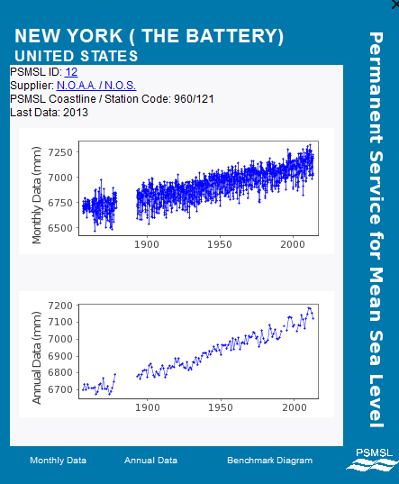
Sea level at Manhattan has been rising at a steady rate since the start of records in the 1850’s. The rate of rise has not accelerated or decelerated over the past 160 years. Experts blame it on melting glaciers.
http://www.psmsl.org/data/obtaining/stations/12.php
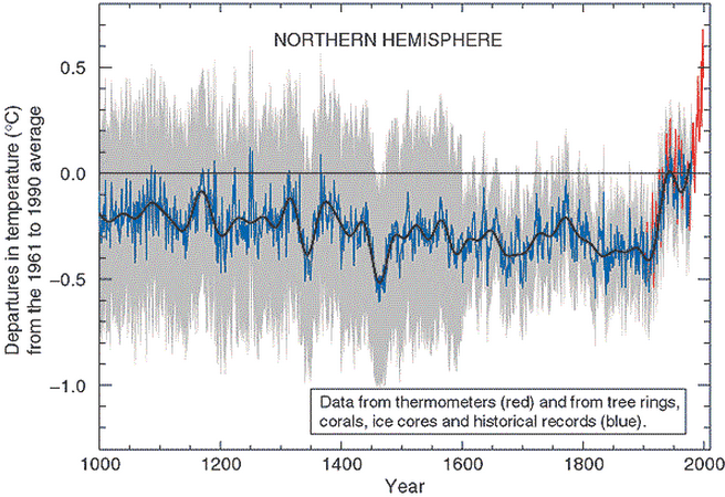
The hockey stick doesn’t start until 1910, yet the sea level rise rate was essentially identical before and after the hockey stick. This tells us that there is no correlation between GISS temperatures and sea level. One station is adequate for this analysis, because melting glaciers would raise sea level more or less equally at all locations.
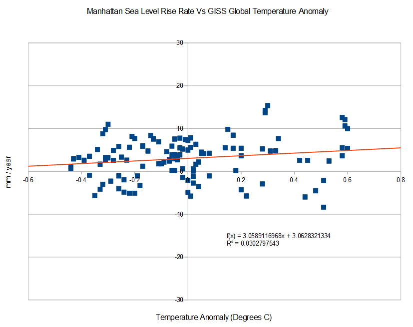
The graph below plots Manhattan sea level rise rates (9 year slope) vs. GISS 5 year mean global temperature anomaly. Again, there is no correlation between sea level rise rates and GISS temperatures. The fastest decline in sea level occurred near the highest temperature anomaly.
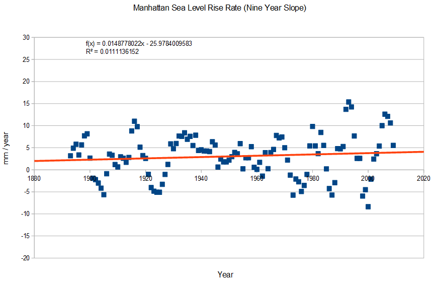
The next trend line is the second derivative of sea level at Manhattan. If there was acceleration occurring, there would be an upwards curvature. There isn’t any acceleration occurring.
You may ask how it is possible that sea level rise rates haven’t changed as the planet has warmed according to Hansen. There are two simple answers :
- Almost all of the apparent rise in sea level is due to land subsidence, not sea level rise. The rate of rise on the East Coast is at least 10X higher than on the West Coast – because the land isn’t sinking on the West Coast. The President apparently believes that a carbon tax can stop subsidence.
- The GISS temperature graph is nonsense. The 1940’s were just as warm as the warmest recent years


“One station is adequate for this analysis, because melting glaciers would raise sea level more or less equally at all locations.”
“The rate of rise on the East Coast is at least 10X higher than on the West Coast – because the land isn’t sinking on the West Coast.”
You managed to debunk yourself in the same post. Well done.
Why does the first comment have to be so incredibly stupid? You have really outdone yourself this time Will.
While you’re free to call people names when they point out that some of your posts are really dumb, you’d be better off correcting them rather than name calling. Then you wonder why other skeptics aren’t fully on-board with all your opinions…
Come on, that was no debunk. LOL! The degree of subsidence at the Battery on Manhattan would have to be determined by some other bench mark than sea level if there is any fluctuation of sea level. We know the east is sinking, I don’t really give a damn how much cause AZ ain’t gonna be flooded anytime soon.
First he claims that one tide gauge is enough to represent the entire planet. Then he points out before he finishes his post that other tide gauges are showing an order of magnitude difference on the opposite coastline.
At the end of the day I appreciate that many blogs tend to attract mindless groupies, but it’s a tough call to defend the indefensible. Goddard’s not infallible, he just thinks he is. 😉
Hey Will! I think that the point Tony is making is slightly different than how you interpreted it (though I could be wrong.) The point is not to say exactly how much the sea level is or is not changing. The point is not even how much any given tide gauge is being affected by land movements. The point is that we are being told that the rate of sea level change has altered dramatically with CAGW. Regardless of whether you choose a tide gauge in a geologically stable area or not, any long term trends in gauge reading from geological changes should be fairly constant on hundreds of years. Unless you posit that the land movement rate has suddenly shifted to exactly negate a climate induced rate change change, you should be able to see an inflection from the historical sea level changes to a new and greater seal level change. Do we, in fact, see an inflection? The answer is, no.
East coast or west coast, geological changes are fairly constant on a scale of hundreds or thousands of years. CAGW induced sea level changes should appear on a decadal scale. We ought to see a “sea level hockey stick” but we don’t.
Hey dude, that first paragraph illustrates completely how closed-minded you and your tunnel vision are. It doesn’t take much to realize the one tide gauge he is suggesting has got to be on a substrate that is neither rising nor falling. That way the one gauge reads for the entire planet. If we nail the east coast tide gauge to the freaking sinking ground you are certainly gonna get an “Oh Shit” moment. It’s a bitch measuring one variable with another variable. By the way, a groupie I ain’t and for mindlessness, maybe you should check your mirror.
All stations would see the same change in slope due to changes in glacial melting. Regardless of the baseline rate, each individual station would see the same global warming signal. If you don’t stop with this stupidity, I am going to do a special post in your honor.
“Regardless of the baseline rate, each individual station would see the same global warming signal.”
Because some land is subsiding and some land is uplifting, and all at different rates, you cannot separate the baseline rate from the global warming signal, if there is one, using a single tide gauge. Unless of course, you try to establish that the gauge is situated in a geologically stable region. This is why one tide gauge in one place doesn’t tell you everything you need to know. This is why all scientific papers that analyse sea level rise look at more than one tide gauge. (Although, I am aware of a certain horribly bad paper that does look at only one gauge, partly authored by the climate scientist we all love to hate.)
This trivial observation is so blatantly obvious, your sense of entitlement to infallibility is only going to end up digging you into ever deep holes, as per usual, Mr Goddard. But please carry on.
Utter nonsense. The trend line in the bottom graph is the second derivative, which is the rate of change of the slope. The first derivative (i.e slope) is completely irrelevant in this analysis. It makes absolutely no difference if any one station is rising or sinking. The only thing that matters is the change in the slope at any particular station, which would be the same at all stations.
“Utter nonsense. The graph is the second derivative, which is the rate of change of the slope.”
Also utter nonsense, because the change in the base line can actually change the direction of the slope. There is also no reason to assume that the rate of change of the base line is not also gradually changing, short of wishful thinking.
(Although you told us a few times that you’re one of the world’s greatest microprocessor engineers, I’m having second thoughts about hiring you to work for my engineering firm, if you can’t understand this simple point. 😉 )
There is no reason to believe that the rate of subsidence in Manhattan has changed. In fact the graph hints pretty strongly that it hasn’t.
You are just wasting everybody’s time and distracting from an important discussion with your BS.
Even if your assertion was true (and it’s only a guess on your part), consider a situation where the land is subsiding at 2mm a decade and sea level rise is 1mm a decade, and another region where the land is uplifting at 1mm a decade, and a third region where the land is subsiding at 1mm a decade. Are you telling me that the direction of the slope will be identical all three tide gauges therefore we only need to consider one of them?
The first example should have been “uplift” not “subside” but you get the idea from my 2nd example anyway.
Homer
It makes absolutely no difference what the baseline is. One changes from 1mm to 3mm. over a century Another changes from 2mm to 4mm. over a century. Another changes from -1 mm to +1mm
All have increased by 2mm/century due to increased glacial melt. Meltwater would spread evenly around the planet. This is basic, fundamental pre-algebra.
Please stop wasting my time and distracting from this important topic. You are totally pissing me off.
You can’t possibly be this stupid Will. The second derivative is the change in the trend. That is what I am discussing. The first derivative (trend) is irrelevant. I have already explained this to you and you are now spam.
If one meter of ice suddenly melts in Antarctica, every tide gauge on the planet will see an equal rise in sea level. If glacial melting suddenly starts adding 3 mm/year to sea level, than each and every station’s trend will increase by 3mm/year.
sea level rise due to glacial melt and land sinking are two different processes. The former is fairly uniform world wide the later varies by locality. Land sinking (or rising) is driven by the continents shifting, erosion, glacial rebound (or sinking) and probably other processes I’ve neglected.
You are quite correct Will, Steve has it completely wrong.
The sea level has gone down since the highstand during the Holocene Optimum. And we are talking in yardsticks not fingernail widths.
Another paper:
The Authors interpret this data to agree with subsidence based on models: ” This history is consistent with geophysical models of postglacial geoid subsidence over the equatorial ocean first predicted by Walcott (1972) and later refined by Clark et al. (1978) and Mitrovica and Peltier (1991).” However if the Southeast Vietnam coast was geologically stable and showing the same type of data, that interpretation based on models is open to question.
Plus there is the information on glaciers (obviously glaciers melting are linked to sea levels rising.)
The paper, Temperature and precipitation history of the Arctic> says: “Solar energy reached a summer maximum (9% higher than at present) ~11 ka ago and has been decreasing since then, primarily in response to the precession of the equinoxes. The extra energy elevated early Holocene summer temperatures throughout the Arctic 1-3°C above 20th century averages, enough to completely melt many small glaciers throughout the Arctic, although the Greenland Ice Sheet was only slightly smaller than at present.”
Another, more recent study in Norway agrees:
The authors of these papers simply state that most small glaciers likely didn’t exist 6,000 years ago, but the highest period of the glacial increase has been in the past 600 years. This is hardly surprising with ~9% less solar energy.
9% less solar energy translates to ~120 W/m² less solar energy based on 1,361 W/m² (solar min) and 1362 W/m² (solar max) @ ToA.
The Intergovernmental Panel on Climate Change [Schimel, 1996] estimated that the change solar forcing between 1850 (start of the industrial age] and 1990 was only •0.3 W/m 2 at the top of the atmosphere vs. 1.5 W/m 2 for forcing anthropogenic CO2 [cf., Reid, 1997].
So we are looking at a REDUCTION in forcing of ~120 W/m² due to the progression of the Milancovitch cycle vs an added forcing of 1.5 W/m 2 for anthropogenic CO2.
The warmists sure will twist and turn and ignore the facts to support their believe the earth is warming, glaciers are melting and the sea levels are rising – OH MY!
There are lots of processes that go into sea level rise and the most important is the rewriting of the historical data by so called climate scientists.
Folks, I’ve got this climate scientist shit figured out. We go to school …”Wow! I’m gonna be a “Climate Scientist”, how exciting! Then we realize working with the climate is like watching grass grow which doesn’t fly in our instant gratification world. Reminds me of the two vultures sitting in the tall dead tree…one turns to the other “Patience hell, I’m gonna KILL something!”. Waiting for the sea level to rise the 3 millimeters per decade or whatever sure doesn’t sound rewarding to me. The grant money certainly doesn’t come a rolling in for that 3mm/decade stuff, gotta do something fast, freaking student loans won’t wait! Ya see! I got this shit nailed.
Sorry Tony, didn’t mean to be silly..
Sea level is one of the stupidest “anthropogenic global warming” relationships.. I usually wouldn’t comment on such a moronic subject, it’s almost as if tectonic plate movement and erosion itself didn’t exist on earth.. but I’m curious, how does CO2 effect “land subsidence”?
Burning coal causes CO2 to rise. Coal is found underground and must be dug out. Digging out coal leaves behind voids that eventually collapse. Therefore, CO2 causes the land to subside. (This torturing of logic is brought to you by the same reasoning behind the rest of modern climate science…)
CO2 is a low lying gas, relative to 1 earth atmospheric pressure, its quantity does not control earths various climatic conditions. CO2 is not relevant to climatic temperature on a planetary scale, regarding temperatures, CO2 does not have this imaginary superpower of keeping an entire planet warm, this gas warms and cools quicker than the surrounding atmosphere as a confined gas, as a well mixed gas it becomes irrelevant.
Carbon Dioxide in our earths atmosphere has a variable not equal to and not greater than the temperature of our planets atmosphere.
“One station is adequate for this analysis, because melting glaciers would raise sea level more or less equally at all locations.” Not at all true. Look it up.
The stabilization of earths polar field at its current geographical location is adequate for sea level.
Everyone is making this much too complicated. This topic is very basic physics and math.
The complicated spin on a simple argument is probably a good sniff test. 😉