
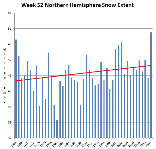
Snow extent is a good proxy for how far south cold air is spreading in the winter. Week 52 Northern Hemisphere snow extent has increased by more than 170,000 Manhattans since 1979, and smashed the old record in 2012. Four of the five greatest snow extents have occurred since the year 2000.
The only way this could happen is if Arctic air is plunging further south than it used to – a sure sign that NASA and NOAA are completely FOS.

dang…does this mean my winter vacation spot in Phoenix is a ‘thing of the past’? Andy DC…how much further south do i have to head too?
Try Panama City, Panama. Even with the ice free Arctic pushing snow farther south, that might still work for you
Why don’t we cherry-pick a starting date (the warmers do it) like 1980 and see the red line showing an alarming increase in snow cover and a real climate threat developing.
This chart actually supports the theory that global warming leads to more snow. From 1966 to 1980 global temperature decreased, and so did the snow extent. From 1980 to 2000 temp & snow increased. From 2000 to 2012 temp & snow leveled off.
You can’t really compare week 52 NH snow to global avg. temperature, but still…
Nonsense.
Do you have the data for NH snow extent and NH temperature? It would be interesting to see a correlation chart.
http://stevengoddard.wordpress.com/2012/12/29/shock-news-snowfall-is-associated-with-cold/
That’s US snow fall, not NH snow extent. I don’t have your data, tools, and knowledge, but I did a little visual comparison based on NOAA data for NH / December:
http://img844.imageshack.us/img844/5220/snowcover.jpg
Visually there doesn’t seem to be any relation at all.
http://stevengoddard.wordpress.com/2011/04/06/winter-snow-is-caused-by-cold/
Except the last IPCC report concluded the opposite would happen. It’s a great theory because no matter what happens the theory gets vindicated.
That is indeed true. From IPCC AR4:
“Snow cover is an integrated response to both temperature and precipitation and exhibits strong negative correlation with air temperature in most areas with a seasonal snow cover. Because of this temperature association, the simulations project widespread reductions in snow cover over the 21st century”.
This does not really match the Week 52 NH snow extent chart above.