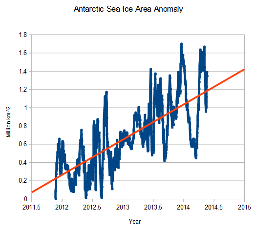
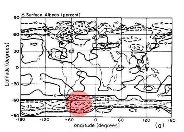
The world’s leading climatologist – James Hansen forecast that Antarctica would see peak sea ice loss, but Antarctic sea ice has been above normal every day for the past 30 months.
 arctic.atmos.uiuc.edu/cryosphere/timeseries.south.anom.1979-2008
http://www.epa.gov/climatechange/effects/downloads/Challenge_chapter2.pdf


You will have to eat your words after the “super duper” El Nino of 2014 boils the Pacific Ocean. (sarc)
I’m impressed. Hansen managed to pinpoint the very area where most of the expansion of Antarctic ice area is happening.
It takes a realclimate scientist™ to divine the opposite of what is actually happening.
That’s because all the superheated water… A billion Hiroshima bombs per minute…. Are all deep in the ocean… When this water hits the Anctarctic it will melt like a Popsicle in the sun…
No, when the superheated water reaches Antarctica, it will stratify the halocline and cause an unprecedented rise in sea ice. This is 97% incontrovertible.
Energy misused is not worth the energy! 🙂
Yet they continute to shamelessly put out daily disinformation about “catastrophic” Antarctic ice loss, when the actual facts are quite the opposite.
Maybe they read graphs upside down. Tasmanians are getting nervous.
http://nsidc.org/data/seaice_index/images/daily_images/S_stddev_timeseries.png
The are only looking at the area in the Antarctic where the volcanoes are active and then using the patented Hansen smear method to extrapolate to the rest of the Southern Hemisphere.
The hidden heat is building under the East Antarctica ice cap, lubricating it so that it will shortly (3,000 years or so) slide off and the slow tsunami of sea rise will roon everything. Just you wait!
Gail you forgot the Steig heat smearing program that heats up the whole of Antarctica LOL
One would hope that before someone makes comments intended to illustrate how climate scientists are just stupid and don’t know what they’re talking about, that someone would at least learn the difference between “sea ice” and an “ice shelf”. Because one is a ephemeral feature in that it waxes and wanes with the seasons on an annual schedule, and has no significant effect on glacial movement, whereas the other is a semi-permanent feature, containing thousands of times as much ice volume as all the sea ice combined, and which adjusts on a schedule of decades or centuries, and is intricately linked to glacial movement, being as how it’s actually part of the glacier.
The primary factor controlling the extent of sea ice around Antarctica is the temperature of the ocean waters surrounding it. Colder water in recent years means more sea ice. Pretty simple, anybody can read that off a chart and understand the relationship, as illustrated here. However, colder water doesn’t just appear out of nowhere, you know. It has to be colder for a reason, and since atmospheric temperature averages ARE undeniably going up, it can’t be the increase in colder weather cooling the ocean, because there isn’t any. Hmmmm. . . .what else could possibly make the ocean colder? While you’re pondering that, please excuse me a moment while I go to the freezer to pop another couple ice cubes in my beverage, it’s getting warm. . .
Okay, I’m back. Now the other thing someone mentioned here is an increase in precipitation, i.e, “more snow” falling on Antarctica to replace that which is melting at the glacial terminus (terminii??). The same thing has been documented in the northeastern part of the Greenland ice sheet, so this is a legitimate phenomenon. But again, we can’t look at things in isolation. If more snow is falling, it must must be that something has changed. What could that be? There are two big factors involved when it comes to snowfall. The amount of moisture in the air, and the atmospheric temperature. Having grown up in a part of the country which (used to have) some pretty nasty winters, I noticed, as have others, that more snowfall occurs with the temperature hovering close to freezing. Go very far in either direction, temperature-wise, and the precipitation (as snow) drops dramatically. This holds true in Antarctica, as well, so what does that imply in relation to an increase in Antarctic snowfall? Either the air has more moisture to precipitate out as snow, or the atmospheric temperature is closer to freezing than before, or both. Since there’s no evidence for any atmospheric temperature anomalies to cause this, it must be more moisture, then.
Which would be expected if global average temperature is increasing. More heat equals more evaporation. So when that air with extra moisture encounters cold air, such as that which exists around Antarctica, you get MORE SNOW.
In Greenland, you will find the same thing – the precipitation increase can also be explained by added atmospheric moisture, this time coming from the evaporation of Arctic Ocean waters which used to be covered by multi-year ice, but which are now ice-free for much of the year. The situation in the arctic is more complicated than just that, however, because temperatures there HAVE risen dramatically in recent years, so that obviously plays a big role.
So there you have alternate answers to the two biggest arguments raised here against the conclusions reached by researchers in climate change. And no advanced degree in atmospheric physics required, just a basic understanding of how weather operates.
What you are demonstrating here with your arguments shows the same degree of in-depth investigative research which leads people to quote Al Gore as saying he “invented the internet”. Well done, keep up the good work!