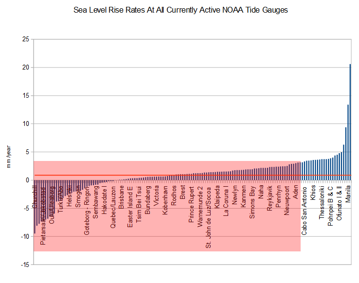
According to always trustworthy US government, sea level is rising 3.1 mm/year. As tiny as this is, it is exaggerated by more than 400% over the actual data. Of the 148 currently active (readings after 2010) NOAA global tide gauges, 83% are below the official average. The 148 stations have a mean value of 0.73 mm/year. Almost a third of the stations show no sea level rise.
Linear mean sea level (MSL) Global Sea Level Trends in mm/yr – NOAA Tides & Currents
As with everything else the government says about the climate, there isn’t one smidgen of truth to the sea level story.


Also they never bother to mention that this is short term sea level changes and the sea level has DROPPED since the highstand during the Holocene Optimum 5-6 thousand years ago.
Another paper:
http://www.soest.hawaii.edu/ericg/kap_paper.pdf
I understand Guam has tipped off the chart above.
I would like to know when the government funded agencies will stop cheating with every darn measurement that they publish. Do these idiots realize that if you have to fake your data then most likely your hypothesis is dead wrong?
I’d be alarmed living on the Philippines. Manila is the new Venice of Asia according to government experts. Must be why the US bases moved to Guam and that’s why Guam is tipping over.
Much of Manila proper has been experiencing subsidence due to groundwater depletion.
Which of these tide-gauges are situated in the middle of the open ocean?
Quite likely the stupidest question of the day.
Yes, but hillarious! Thanks Kassu.
Between U and Bob tisdale. Difficult to calculate who is the most arrogant and rude
last laugh on us Kassu. LOL
All climate experts know that whales, which evolved in 1976 per consensus, can live happily in water that is 7000 meters deep, but if it gets 4mm deeper, they’ll drown.
You could swim out to this one. From whatever direction you come from it ain’t close.
http://www.psmsl.org/data/obtaining/stations/1831.php
Here is a map, from the same source as Steve’s chart, showing distribution of gauges. Click on minus sign to see all oceans:
http://tidesandcurrents.noaa.gov/sltrends/
The absurdity of using sea level for any agenda is just beyond me. The range of results precludes any logical conclusion being made in either direction. The effects appear to be local, and not due to any global effect. Man made or not. Our local high tide mark at Marino (South Aus) still looks the same as it did 40 years ago. Kiribati is still my favourite. https://eyesonbrowne.wordpress.com/2014/04/25/kirabati-sea-level-rising-or-falling/
Maybe I’ll buy some land there. Bound to be cheap with all of the climate refugees wanting to move to NZ.
On the subject of the ridiculousness of sea level measurements, i like number 7 in this list
http://www.bbc.co.uk/news/magazine-27509559
Sorry, cant seem to link directly to it you have to scroll down…
Scandinavia, still rebounding from the last ice age, is overrepresented with many tide guages, skews the average sea level down. Kassu made a non stupid point, Manila is not open ocean, but in it.
I can’t believe someone as stupid as this “bobmaginnis” character is capable of using a computer. Literally everything he says is the philosophical equivalent of a Terrance & Phillip movie.
You say that the mean is 0.73 mm/year. I’m curious to know what the median is.
Why are there no U.S. cities in that graph? Don’t we have any currently-active NOAA tide gauges here? I thought there was one in Alameda. What does the pink box on the graph represent?
Try clicking on the link for the full list.
The full link doesn’t have any U.S. cities either.