
From the White House climate report
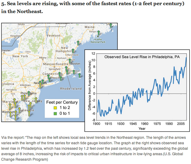
The Philadelphia sea level graph shows no acceleration since 1900, destroying their own claim that sea level rise rates have doubled since 1992. And anyone with an IQ higher than a turnip would recognize that sea level can’t rise long term at different rates in different places. The steady Northeast US trend is due to subsidence caused by glacial rebound in Canada. As Canada rises, the Northeast US sinks – like a teeter totter.

The steady Northeast US trend is due to subsidence caused by
glacial rebound in Canada. As Canada rises, the Northeast US
sinks – like a teeter totter.
Repeat for emphasis.
Post glacial land rebound (and … surprise! subsidence also) – made possible through the use of GPS technology:
http://www.unavco.org/community_science/science_highlights/glacial_rebound/glacial_rebound.html
– – – – –
GPS is measuring the present motions associated with the response of the earth to the great mile-thick ice sheets that covered the area 18,000 years ago. Long after the glaciers melted, we use the Global Positioning System (GPS) satellites to “see” the land moving — up to half an inch per year in some places — as the earth rebounds in response to the ice that once pushed the land down. Looking at data from more than 200 sites across the continent shows a spectacular pattern. While sites in Canada are rising, with those near Hudson Bay — which is where the ice load was heaviest — rising the fastest, U.S. sites south of the Great Lakes are sinking instead of rebounding. These small motions result from post-glacial rebound” and stem from the fact that the mantle below the earth’s crust flows like a super-viscous fluid — much, much stickier than road tar or maple syrup. The mantle is still flowing to fill areas underneath the places where the heavy ice sheets pushed out the mantle 18,000 years ago.
Post-glacial rebound also affects the water levels of the Great Lakes. As the northern shores rise, water levels are steadily decreasing. Conversely, as the southern shores sink, water levels are rising. This impacts not only industries and homeowners along the shores of the Great Lakes but also the international management of water levels, dams and shipping. These small motions may also be one of the causes of the mysterious earthquakes that occur in the center of the North American continent, including the St. Lawrence Valley, northern New England, and perhaps even the New Madrid earthquake zone in the central U.S., and along the Atlantic coast including Newfoundland.
http://blackrod.blogspot.ca/2014/05/the-climate-change-choir-tunes-from-past.html
These messages were approved by the idiot-in-chief.
What did you expect facts?
Reality was not stretched quite far enough, incredulity was not the maximum that could have been achieved, nor were the lies quite ‘tall’ enough in stature; in short, I was disappointed.
😆
The effective sea level rise at the tip of Manhattan (which you have mentioned before), which is a combination of oceans rising and land sinking, has been a constant rate since before the Civil War.
http://tidesandcurrents.noaa.gov/sltrends/sltrends_station.shtml?stnid=8518750
How can sea levels be measured in Philadelphia? It’s about 50 miles in land, on the Delaware River.
Through the use of precision GPS-based equipment? … making that measurement using a simple tidal gauge would seem to be a problem …
What’s needed are some Marine Expeditionary Units in the Yukon to tilt the continent back into balance.
“My fear is that the whole island will become so overly populated that it will tip over and capsize.” —Rep. Hank Johnson (D-Ga.)
Visual isostatic rebound:
http://www.panoramio.com/photo_explorer#view=photo&position=98&with_photo_id=40688562&order=date_desc&user=4946513
Even more interesting is, the West Coast is rising while the East is falling due to the entire continent moving westwards.
The obama White House is a Cheat, period.