Learning To Analyze Data Like An Arctic Expert

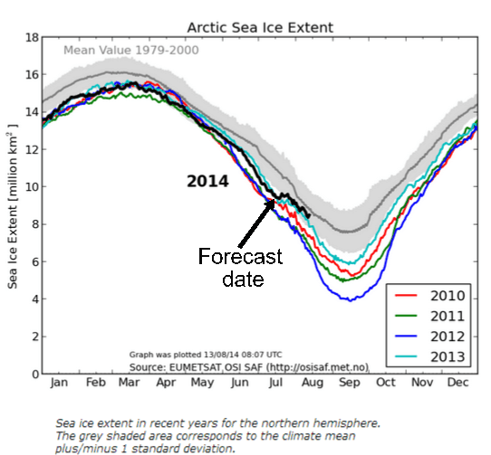
During the first week of July, I predicted that Arctic sea ice extent was about to take a sharp turn towards the median. This was based on very simple geometry, geography, current ice conditions and the weather forecast.

Our friends went ballistic, wrote up a story on ClimateCrocks, and sent an army of idiots over here. Five weeks later some of them are still hanging out here claiming that I was wrong. Apparently you just can’t fix stupid.


ScreenHunter_1899 Aug. 13 07.17

COI | Centre for Ocean and Ice | Danmarks Meteorologiske Institut

About Tony Heller

Just having fun
This entry was posted in Uncategorized. Bookmark the permalink.

27 Responses to Learning To Analyze Data Like An Arctic Expert

  1. philjourdan says:

    Drudge draws them in. The tenacious ones hang around for awhile before they fade away. never having achieved their goal. Which is to convert rational people to their irrational religion.

  2. Eliza says:

    Actually it looks like it might cross the verboten line this time (uptick starting again) as you said some days ago its mostly consolidated now and can only freeze more from now on…

    • I would be very surprised if it crosses over, because wind conditions are unfavorable

      • Gail Combs says:

        We can always hope.

        But I will settle for another ‘polar vortex’ hitting the east coast lefties and freezing their buns off this September. (And watching the MSM try to spin Gore Bull Warbling is causing the cooling.)

    • stewart pid says:

      A little early to be saying “can only freeze more” … look at the graph and the real freeze is usually timed about Sept 10 – 20th before that some areas are freezing and some melting with overall melt or nothing but ~ mid September the net is more freezing than melting.

  3. kbray in california says:

    Now, apparently, Detroit has NEVER EVER had a flood before:

    http://mashable.com/2014/08/12/detroit-flooding-global-warming/

    And, of course, it is caused by your SUV.

    • Fred from Canuckistan says:

      Funny how Detroit flooded while Windsor Ontario, a few hundred yards away seemd to have the public drainage infrastructure to handle heavy rain.

    • _Jim says:

      Looks like Dallas after receiving one of our usual heavy rains; the problem is the drainage in those _low_ areas is not optimum for heavy rains … but ‘Mashable’ (nor the ignorant WH headed by Valerie Jarrett) wouldn’t know such things … they’re Type “A”, Class “1” idiots …

  4. bit chilly says:

    the problem is none of them believe there is anything but fragile new ice left in the arctic steve ,there is every chance they will have a fit next melt season when there is substantially more 3m plus ice.
    i see people looking at satellite images of the arctic and commenting on how much the ice looks like slush,while failing to comprehend they are looking at huge slabs of ice that are metres thick as opposed to thin ice on the brink of melting. they see what they want to see,not what is actually happening.

    i think some of them actually want all the ice to melt .

    • squid2112 says:

      i think some of them actually want all the ice to melt .

      Just curious as to what you think might happen if it did? … Exactly what difference would it make to anything? … You are aware that the Arctic has done that before, right?

      • Gail Combs says:

        What happens if the Arctic Ice all melts?
        RACookPE1978 sort of answered that question. (Since the Arctic is a sea it does nothing to the sea level. What it does do is effect the weather.)
        ‘Since I think he had some things to say that are at least worth thinking about I am going to reproduce them here. (They are a couple of comments on the same subject and since they are technical they are long.)

        [in answer to this comment]

        The sea ice surface albedo is estimated using two steps. First, the clear-sky planetary albedo associated with 100% sea ice cover is computed from an ordinary least squares linear regression between albedo and sea ice cover for each month constrained to go through an ocean albedo of 0.175 (cf . ref. 25) at 0% sea ice cover. For this calculation, a region containing all ocean grid cells between 80 and 90°N is used to reduce the extrapolation to 100% ice calculation and to focus on multiyear ice for comparison with the in situ observations.

        RACookPE1978 says: @ WUWT on February 17, 2014 at 2:20 pm says
        Nope. I have to disagree. Those values are NOT what the measured albedos actually are.

        Dr Curry’s measured actual, real-world Arctic sea ice albedo begins at 0.822 in January, stay near-constant until early May, decreases until day-of-year 206 ay 0.46 (best fit, lowest sea ice albedo = 0.38) then rises until day-of-year 275 back to 0.823. It stays at 0.82 until the end-of-year on day = 365.

        Actual real-world measured ocean albedo is available from several different open ocean (real waves and winds!), and varies based NOT on any assumed values of anything, but can be specified (under these conditions of the study = clear day, arctic conditions, direct radiation values). The open ocean albedo varies specifically according to solar elevation angle (SEA) and it varies EVERY HOUR OF THE DAY according to very specific deeper calculations of declination number (DAY variation), hour-of-day variation (HRA), and latitude.

        Further, the actual solar radiation at top-of-atmosphere varies significantly but predictably as a direct function of day-of-year and yearly average TSI value.

        On any given day of year, at any chosen latitude, I have a specific spreadsheet available to any who wants it calculating the actual direct and diffuse radiation at TOA, expected radiation on a perpendicular surface and on a flat (horizontal) surface for all 24 hours of the day, and the expected absorbed and reflected direct and diffuse radaition based on that day’s sea ice albedo and that hour’s solar elevation angle. All are invited to offer corrections or extensions, revisions or ridicule – as long as each has a verifiable measured data contradicting any function. (For example, there are several different ways to calculate air mass, and several other ways to assign a clear-sky attenuation coefficient.

        Hint: A “monthly” value is meaningless unless it is based on a hour-to-hour changing value – at the actual altitude where the ocean and sea ice actually are.

        Hint: Actual measured ocean albedo against direct radiation on clear days vary hour by hour from 0.40 (or higher!) at SEA under 6 degrees down to 0.035 (at SEA’s over 40 degrees). Open ocean direct radiation albedo does vary with wind speed, lowering as wind speed increases and lead size increases – neither effect is mentioned in their “average” 0.17 value.

        Diffuse radiation does NOT vary with solar elevation angles, and varies only slightly with moderate wind speeds, but stays right at the “common” average of 0.065

        The proportion of diffuse radiation received to theoretical-clear-sky direct radiation DOES vary significantly with solar elevation angle, but understand that there is ALWAYS “some” diffuse radiation present even during clear skies, but there may be no direct radiation present at all under cloudy skies. In mid-summer in the Arctic, there may be only one day in seven that actually sees “clear skies” direct radiation! The rest of those six days during the summer, 45-70 percent of the “potential” radiation is reflected away by the tops of the clouds and attenuated by the atmosphere, and only that minute 30% of what arrives at the TOA is left over to actually hit the surface.

        Hint: The location of all Antarctic sea ice varies between 59.2 south latitude in September last year to 70 south latitude in late February. This creates a very, very significant different effect from the Arctic sea ice which is retreating from 70 north in February to 80 north in September. Sea ice albedo (Antarctic sea ice is almost entirely first year clean ice, arctic sea ice contains many million km’s of secondeyar, third year, and even fourth year ice. All other variables change as well: solar exposure times, and top-of-atmosphere radiation values, and ocean albedo are changing as well.

        Now, did the writers actually make every one of these very important changes to every variable? They did not say so. You hope they would. But they didn’t say they made any of them.

        RACookPE1978 says:
        February 3, 2014 at 3:28 pm

        The second assumption about Arctic Amplification, and easily the second most important assumption in the entire CAGW religion, is how the CAGW dogma assumes the albedo change as the polar icecap reduces will affect future climate. Sea Ice vs Open Ocean albedo does matter, and, in truth, really deserves a long conversation in its own entire thread, but let’s look at few important things.

        One. Continuously increasing positive Antarctic Sea Ice anomalies between 70 south latitudes and 59 south latitudes every day of the year for the past 15 years DO affect the world’s heat balance, but Arctic sea ice declines since 1979 – which occur between 78 north and 85 north in September each year do NOT affect the earth;’s heat balance.

        Two. Arctic sea ice albedo DOES change routinely over the year, and is lowest during the yearly June-July-August melt season. Actual Arctic sea ice is NOT the pristine Wikipedia-approved laboratory values you so often see quotes: 0.95, 0.90, 0.86, etc) Actual measured Arctic sea ice (Curry, JGR 2001, Applications of SHEBA/FIRE Data to Evaluation of Snow/Ice Albedo Parametrization) is available for 13 years now, but seldom accurately called out. Figure 1 of Curry’s measurements shows the following:
        From DOY = 1 (1 January) to 133 (May 14), albedo is basically that of new snow over old ice. 0.8228
        From DOY = 134 to 278, albedo decreases from 0.82 down to at minimum curve fit at 0.460 on Day 206 (July 26), then increasing back to Day 278 (Oct 6).
        From DOY 279 – 365 (6 Oct – 31 Dec), measured Arctic sea ice albedo returns to that same snow-covered ice value of 0.82
        Numerically, this is a flat line = 0.8228 until DOY 133, a sinusoid dropping to a low point = 0.460 at DOY 206, and a second flat line after DOY 279 until 365: The sea ice albedo best-fit curve is
        sea_ice_albedo = 0.06803 + 0.02015 *cos(0.03561 * DOY – 4.1809)
        Actual data points scatter somewhat of course, but the measured lowest arctic albedo was 0.386 on DOY 223. Next lowest measured albedo was 0.41 on DOY = 208.

        Three. Of the 19.5 million square kilometers of Antarctic Sea Ice, all but a little bit 3.0 Mkm^2 immediately around the continent melts every Nov-Dec-January (Antarctic summer, Arctic winter). Thus, Antarctic sea ice is always “first-year” ‘ice, and ice thinner and cleaner (with greater quantities of fresh snow from the near-continuous storms around Cape Horn) than the multi-year (darker) Arctic sea ice. Until more measurements are published, that 0.82 albedo is valid all year.

        Four. Sea ice DOES reflect slightly more energy into space all year than does open ocean water, but the actual open ocean albedo is NOT the very dark, pessimistic foreboding but Wikipedia-approved 0.061. Now, understand that the “standard” 0.061 water albedo IS correct, but ONLY for very diffuse light under completely clouded skies.

        So, if the skies are cloudy the open ocean albedo is low, BUT the top of the clouds DO reflect some 30% of the potential solar energy present, the clouds absorb some 30% of the potential solar energy present, and so only 30% of the potential solar energy can be absorbed by the open ocean.

        Five. Do not ever let anybody conn you into using the “pure physics” laboratory-theoretical pristine-perfectly-calm conditions for a perfect-reflecting pure-water surface Fresnel equations either! THOSE values are NOT correct in the real world at any time.

        Rather, actual open-ocean direct-sunlight clear-sky measured-albedos – YES, WITH REAL OCEAN WAVES ! – have been available for many years, but these are seldom used: Most importantly, they CANNOT be used in “average” monthly “average albedo” tables or annual albedo summaries. See, solar absorption into the ocean (or ice) and solar energy reflection from the ocean (or ice) is a constant, minute-by-minute surface interaction very dependent on the latitude, amount of clouds and percent of clear sky, atmospheric air mass (how much light is absorbed merely passing through the even a “perfect atmosphere” to get down to the ocean’s surface), atmospheric clarity, and the day-of-year, solar declination angle, hour-of-day. The latter three combine to define the ever-changing solar elevation angle SEA each minute of each hour of each day.

        (SEA is also written as solar zenith angle SZA in many papers = which is the angle DOWN from the vertical to the sun’s position. SEA is the angle of the sun UP from the horizon to the sun. I will use only SEA to keep one consistent term in use. Many building and solar panel calc’s require plotting azimuth angles for each minute, but – since we are only talking flat surfaces of ice and water at the earth’s sea level, we will ignore the solar azimuth angle and altitude albedo corrections.)

        So, what is this “measured open-waters, clear-sky, direct-sunlight, wind-corrected” ocean albedo? Jin (GRL 2004) Figures 1-5 plot it rising from 0.035 at SEA = 71.8 to a 0.25 maximum (and a 0.21 average) at SEA = 9 degrees), but they only used the values as albedo vs SEA as look-up tables. Payne, (JAS, 1972) Figure 4 also plots it (rising from 0.040 at SEA = 74 to 0.44 at SEA = 8 degrees) but he does not offer a numeric solution.
        Rutledge and Schuster (P5.17, Multi-Year Observations of Ocean Albedo from a Rigid Marine Platform) plot both clear-sky direct radiation and cloudy sky (diffuse radiation) albedos in their Figure 4: If any can post that image, nothing will more strongly emphasize the difference between direct and diffuse radiation behavior reflecting from the real-world open ocean!
        Briegleb (1986) does give a equation, but it does not correct for wind conditions:

        albedo_direct_sun_clear skies = 0.026/(mu^1.7 +0.065) + 1.5*(mu-0.1)*(mu-0.5)*(mu-1.0)

        where mu = sine of that hour’s SEA. (Curry has quoted this equation in her papers.)
        Pegau and Paulson (International Glaciological Society, 2001, The Albedo of Arctic Leads in Summer) worked under the SHEBA ice platform with Curry’s team, and corrected Breigleb for wind speed:

        albedo_direct_sun_clear skies (SEA, wind) = 0.026/[(mu^1.7 + (-0.0002w^2 + 0.0076w+0.0266)] + 1.5*(mu-0.1)*(mu-0.5)*(mu-1.0)
        where mu (again) = sin(SEA) (or cos SZA) and w is in meters/sec.

        So, in September in the high Arctic when the solar elevation angle SEA is NEVER more than 8-10 degrees above the horizon at ANY time of the day when the sun is even visible, what is the measured clear sky open ocean albedo? Between 0.22 and 0.35.

        Not all that much different from the albedo of the “dirty sea ice” that is melting away. Yes, there is an increase in absorbed radiation in the Arctic above 78-82 latitude when sea ice is replaced by open ocean, BUT it is not very much difference in energy over the 12 hours of even potential sunlight!

        And, although the sun’s rays do heat the open water slightly during those daylight hours, the open water about 78-82 north loses MORE HEAT to the sky over the entire period of the 24 hour day through increased long-wave radiation, increased evaporation, increased convection, and increased conduction than does sea ice!

        Rather than an “arctic sea ice amplification” the numbers show that – during the late melting season under today’s conditions, every square meter of open ocean north of 76-82 north LOSES more heat on a daily basis than does sea-ice-covered arctic waters under the same air conditions!

        The exact opposite, unfortunate, is also true down south:
        Under today’s conditions at Antarctic sea ice extents between 60 south and 70 south latitudes, EVERY square kilometer of increased Antarctic sea ice at ANY time of year reflects more energy into space away from the planet, INCREASES total planet cooling!

        http://wattsupwiththat.com/2014/02/03/new-paper-arctic-amplification-of-temperature-not-primarily-due-to-albedo-changes-climate-models-need-to-be-reworked/#comment-1557816

        http://wattsupwiththat.com/2014/02/03/new-paper-arctic-amplification-of-temperature-not-primarily-due-to-albedo-changes-climate-models-need-to-be-reworked/#comment-1557907

        The Spreadsheet is at http://wattsupwiththat.com/2014/02/17/crises-in-climatology/#comment-1571641

        • kbray in california says:

          Gail, are you typing all this on your iPhone ?

        • Gail Combs says:

          No, I am having major problems seeing due to allergies. The old bod, really really hates all the mold in the air.

          I do wish an edit function was available in WordUnimpressed.

  5. jjreuter says:

    So their AlGoreithm is not helping their models?

  6. ossqss says:

    When you mask out the coastal zones it paints a telling picture.

    http://ocean.dmi.dk/arctic/old_icecover.uk.php

  7. Shazaam says:

    I will bet those cruise lines booking passage for Northwest Passage Cruises have weasel terms in their contracts to avoid refunds in the case of “inclement ice”.

    Otherwise, they’ll be quietly cancelling those cruises.

  8. anthonyvioli says:

    Isn’t it amazing what a rational and non agenda driven human can forecast?

Leave a Reply

Your email address will not be published. Required fields are marked *