
The University of Colorado shows sea level rising at a steady rate of 3.3 mm/year, which is a higher rate than 84% of tide gauges report

But they didn’t always show that. In 2004, they showed the rate of sea level rise as 2.8 mm/year
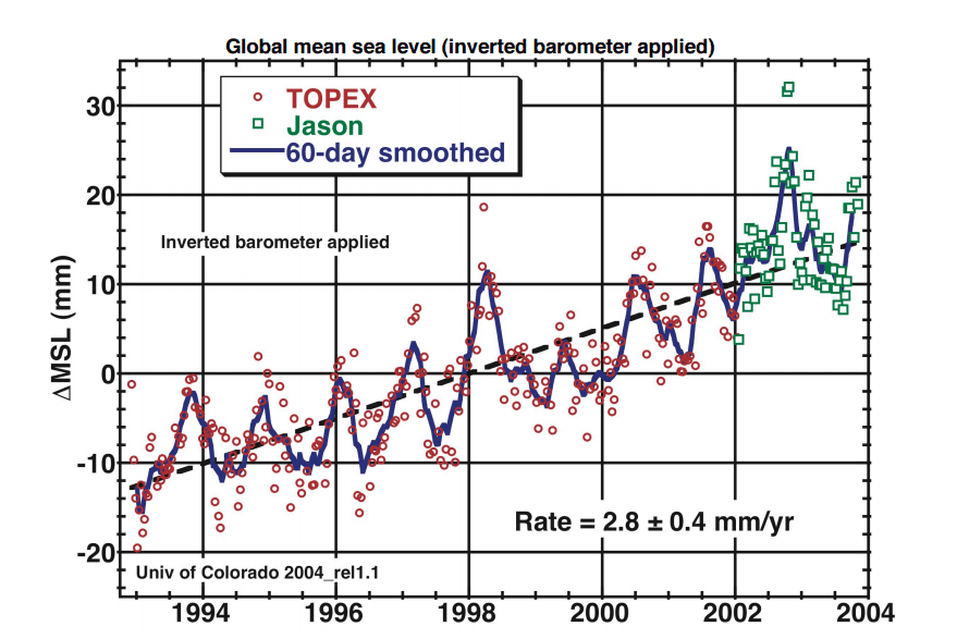
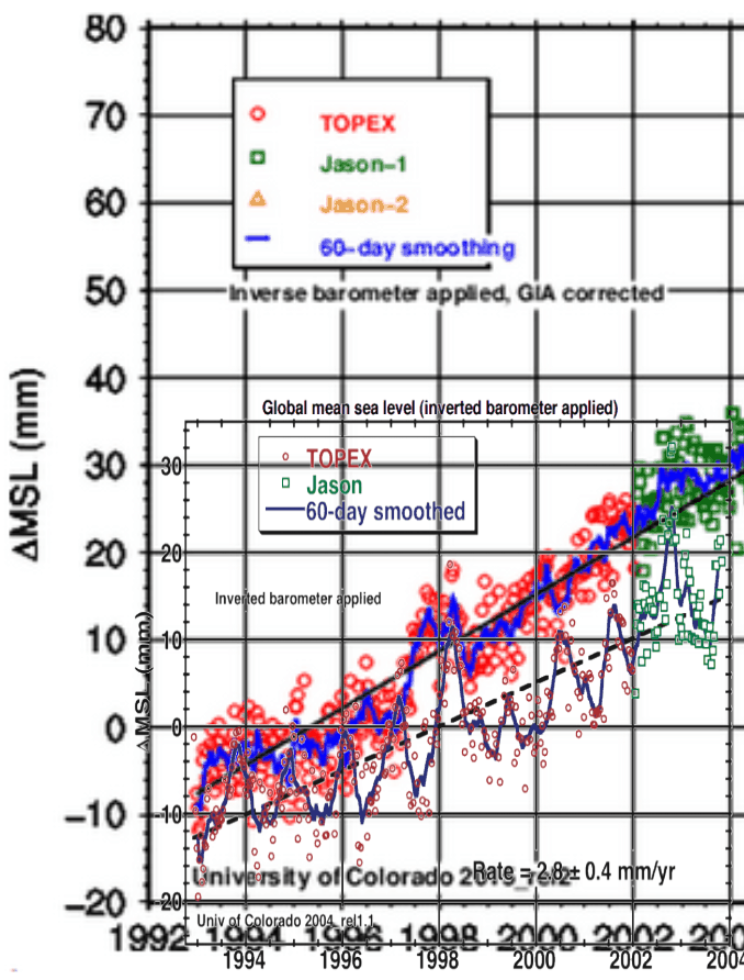
Overlaying the two graphs (of the same data sets) you can see that they don’t look anything like each other. In the old graph, there was a trough in 1997, and in the new graph there is a peak that year.
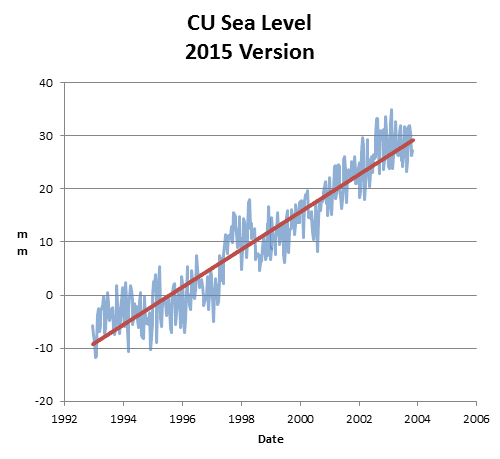
The next animation shows how their published data set has changed since 2004.
2004 : sl_ib_ns_cu2004_rel1.2_global.txt
2015 : 2015_rel2/sl_ns_global.txt
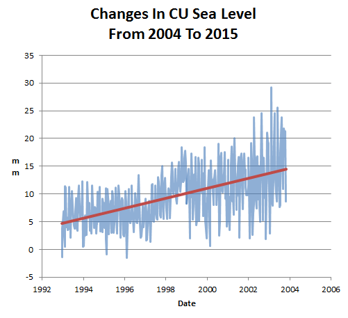
The next graph shows the changes made to the data. They added an extra 10 mm of sea level rise from 1993 to 2004.
As with every other US government funded climate data set, the data is continuously being altered to create the case for imaginary global warming. The temperature is not increasing, so they have to keep faking the data to keep the scam alive.

h/t to Steve Case

Thank you Steve (-:
Yes, temperature isn’t the only climate data that’s being corrected on a continuing basis.
When exactly did this change happen? I think it was not until about 2006 or 2007. The reason is at about that time I recall a very flat trend, and a fair amount of chatter about it.
I recall UC updates then stopping for some time, and then the new charts came out, erasing the flat trend shown here from about 2002 to 2006. This was before the IR adjustment, but I cannot find any charts of that time frame.
Once you have to lie about one thing you have to lie about a million things and keeping track of these lies becomes harder and harder then it all collapses.
Reblogged this on Centinel2012 and commented:
More deceit piled on past deceit making the worlds biggest compost pile — yet it goes on and on and no one cares that they are living in a pile of manure. This blog and a few others are the exception, of course.
If a pharmaceutical company altered the results of a clinical study of a new drug to gain approval, everybody involved would be in jail and the media would be cheering the prosecutors.
I would not bet on that….
Research Misconduct Identified by the US Food and Drug Administration: Out of Sight, Out of Mind, Out of the Peer-Reviewed Literature
http://medcitynews.com/2011/07/fda-says-cro-cetero-faked-trial-data-pharmas-may-need-to-redo-tests/
The USDA did the same thing with the big boys and e-coli Shielding the Giant – Government Accountability Project
USDA’s “Don’t Look, Don’t Know” Policy
OH, and the latest is Obummer is calling the Garland TX Jihadists ‘Lone Gunmen’ as the FBI is busy digging out the Jihadist’s network from the computers….
……………….
I am really really getting sick of all the lies.
Here is another:
It’s Not the ‘Radical Shaykh’ It’s Islam – Fahad Qureshi
https://www.youtube.com/watch?v=bV710c1dgpU
If you go to the page
(wwwDOT)youtube(DOT)com/watch?v=bV710c1dgpU
The blurb under the utube is the biggest bunch of double talk I have ever seen in my life!!!
UNBELIEVABLE!!!
So much for moderate islam.
I just posted a partial transcript of the talk for our resident Islamic scholar Abu London here:
https://stevengoddard.wordpress.com/2015/05/07/cartoon-of-the-prophet
Thanks Colorado.
If a muslim is a ‘moderate’ it just means he is not religious or lying.
Well, PJ London’s happy with the posted video and transcript.
He sees it as a good thing.
———-
Fahad Qureshi’s video & transcript:
https://stevengoddard.wordpress.com/2015/05/07/cartoon-of-the-prophet/#comment-521973
PJ London’s comment:
https://stevengoddard.wordpress.com/2015/05/07/cartoon-of-the-prophet/#comment-522018
Reblogged this on Climatism.
Once CU got involved in the CAGW meme it was just a matter of time before they felt compelled to keep up with the Jones’s. How do you keep up with the Jones’s in climate science? You “fudge”, “alter”, “cheat”, “massage”, “torture”, “obfuscate”, “muddy”, “muddle”, “blur”, and “cloud” the data. The data must not look like it did originally, it must conform to CAGW.
What CU is doing is not science. What NOAA, and GISS are doing is not science. No where do you see the scientific method used. It only takes one good data point to disprove a theory. The CAGW theory would have died out decades ago is scientists had been true to the scientific method.
Damn shame to see so much corruption and misuse of my taxes.
Any published justification for these alterations? Do they have a built in algorithm or is this hand-and-eyeball work. What gives?
inMAGIC
What gives, well we do, mostly money, which leads to power, control, inflated egos and more.
darrylb. I’m with you 100%, but they can’t admit to that. What do they say that they use to publicly JUSTIFY these alterations?
With the Big Lie, justification isn’t as important as making the LIE ubiquitous (everywhere you turn), making sure it is repeated it over and over. And ad hom attacks against anyone who dares point out inconsistencies, lies, and/or unjustified claims. And shifting to other cherry-picked (and/or ‘adjusted’) scary ‘data’. Dealing with CAGW propaganda is like playing Whack-a-Mole.
I do daily search of sea level in the news. Today was busier than usual:
http://www.theguardian.com/environment/2015/may/11/sea-level-rise-accelerated-over-the-past-two-decades-research-finds
http://www.washingtonpost.com/news/energy-environment/wp/2015/05/11/sea-levels-are-rising-at-faster-clip-as-polar-melt-accelerates-new-data-shows/
http://news.sciencemag.org/climate/2015/05/sea-level-rise-accelerating-faster-thought
http://www.wsj.com/articles/sea-levels-rose-less-than-thought-but-at-faster-pace-study-says-1431360556
http://www.smh.com.au/environment/clearer-view-of-rising-sea-levels-finds-problem-accelerating-20150511-ggytf5.html
Tide gauges show an annual rate of a little over 2 mm/yr over the last 30 yrs and an acceleration of about 0.2 mm/yr² over the last 60 years. If that were to continue, we would see 10 inches of sea level rise by 2100.
The satellite record since 1992 shows a negative acceleration of minus -0.05 mm/yr².
Anyone with an Excel spread and some time on their hands can figure these things out for themselves.
Care to comment on this paradox? Some do not like satellite estimates of sea levels so they prefer surface measurements of tide gauges. Most of these same individuals do not like surface measurements of temperatures and prefer satellite estimates.
By the way, I do have an answer . . . but it is best to be prepared for accusations on this paradox.
The answer is quite simple, we know where the “Quality Adjustments” have taken place, so we don’t beleive them.
That is not to say they we disbelieve the RAW data though, especially thermometers.
It is also strange how the Satellite showing a steep reduction in seal level rise was the only one that died, just call me paranoid.
These time lines of data stand as their own testimony. You don’t have to call the people who run them names or make sarcastic comments.
Long term the seal level is falling
TEN STUDIES PROVING SEA LEVEL HAS NOT RISEN AFTER HOLOCENE OPTIMUM
An Inquirer asked, “Care to comment on this paradox? Some do not like satellite estimates of sea levels so they prefer surface measurements of tide gauges. Most of these same individuals do not like surface measurements of temperatures and prefer satellite estimates.”
The short answer is that for sea-level the tide-gauge data is much better quality than the satellite data, and for temperature the satellite data is probably of better quality than the surface station data.
Long answer:
W/r/t sea-level:
1. There is good reason to believe that global trends should affect all locations about the same, modulo differences in local land movement (subsidence or uplift).
2. Most sources of local land movement, other than extraction of groundwater, oil and/or gas, and earthquakes (which are rare and well-documented), are approximately linear over century time scales, so they do not much affect/distort determinations of sea-level acceleration/deceleration.
3. Thus, comprehensive coverage of the Earth’s oceans is unnecessary, if you’re trying to detect acceleration/deceleration in sea-level trends.
4. Tide gauge data quality is excellent going back much more than a century, but satellite altimetry measurements only go back about 22 years.
5. Measurement of sea-level by satellite altimetry is inherently unreliable, as Dr. Willie Soon explains starting at 17:37 in this very informative hour-long lecture, and measurements by different satellites have produced highly inconsistent data.
6. Tide gauges measure sea-level at the coasts (where it matters). Satellites are incapable of measuring sea-level at the coasts.
7. Upper-layer thermal expansion affects satellite measurements of sea-level but does not appreciably affect coastal sea-level (where it matters).
8. Thus, tide-gauge measurements are clearly superior to satellite altimetry for determining global sea-level trends.
W/r/t temperature:
1. There’s no good reason to believe that surface air temperature trends should be the same everywhere, e.g., over the oceans (where there are no measurement stations) vs. land (where there are measurements stations).
2. That means comprehensive global coverage is important for computing global average temperatures, and only satellites provide it.
3. The global surface temperature record is spotty and of poor quality, being subject to very common distorting factors, such as UHI, measurement methodology changes, computational changes, etc.
4. Thus, unless you need data which precedes the satellite record, satellites are probably superior to surface stations records for determining globally averaged temperature trends.
For example:
http://oi57.tinypic.com/11ui0cp.jpg
What I think would be interesting is to see what sort of links there are between the “data adjusters”.
We know that CRU and GISS, NOAA, NCDC are all pretty close, and there names, such as P. Stott that comes up quite often in CRU, BOM, CSIRO, and even the Kiwi temperature adjustments.
So, are there any links between say Potsdam, Colorado uni, etc etc
What might also be interesting would be to trace back grants and funding, see where it all leads.
GMSL Rates
CU: 3.3 ± 0.4 mm/yr
AVISO: 3.3 ± 0.6 mm/yr
CSIRO: 3.2 ± 0.4 mm/yr
NASA GSFC: 3.2 ± 0.4 mm/yr
NOAA: 3.2 ± 0.4 mm/yr (w/ GIA)
http://sealevel.colorado.edu/
Herd mentality. Tide gages are history.
I’m sure a lot of these guys all know each other.
Steve
FYI
I just heard ABC radio news (Australia) banging on about new CSIRO findings of the missing acceleration in sea level rise – which now fits the 1 metre of IPCC projections.
I only heard part which didn’t have a reference.
Well they sure didn’t use local data !
Fort Denison (Sydney Harbour) sea level is rising a very rapid and scary 0.65mm/year
http://tidesandcurrents.noaa.gov/sltrends/sltrends_global_station.htm?stnid=680-140
To scare you even worse, Prof. Peltier estimates GIA there at 0.09 mm/yr uplift. So 0.65 + 0.09 = 0.74 mm/yr sea-level rise. That would add up to almost 2.5 inches by 2100, if it continues.
Terrifying, isn’t it? How are we supposed to sleep at night, with such a threat hanging over us?
For those interested, here’s paper discussing NSW sea levels.
They give an even scarier 0.9mm/year for Fort Denison, but only 0.4mm/year since 1986 due to El Nino conditions.
http://www.coastalconference.com/2011/papers2011/Ben%20Modra%20Full%20Paper.pdf
New posting from Jo Nova on sea level rise
. http://joannenova.com.au/2015/05/the-scandal-of-sea-levels-rising-trends-acceleration-largely-created-by-adjustments/
Superb work Steve, and as ever another brilliant public expose by er, Steve. :-0
As the Soviet Communists used to say, “Only the Future is certain, the Past is constantly changing”. Joseph Stalin would have admired this herd of “Climate Scientists” if he could have seen them in action.
Reblogged this on Globalcooler's Weblog.
Reblogged this on The Grey Enigma.