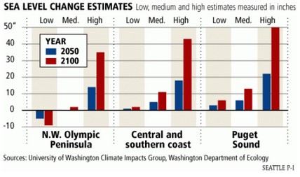
Parts of Puget Sound could rise 2 feet
Scientists offer projections on higher sea levelJanuary 17, 2008
A study released Thursday by scientists with the University of Washington and state Department of Ecology could help answer that question.
In the worst case — which assumes high levels of greenhouse gas emissions and faster melting of ice sheets — Puget Sound is inundated with nearly 2 feet of water by midcentury, more than 4 feet by 2100.
Experts indeed tell us that greenhouse gases are rising faster than expected and ice sheets are also melting faster than expected (at -50C.)
Sea level in the region has been completely steady since 1975, Tamino’s period of modern global warming. Once again, scientists are trying to pretend that they know something scary, when in fact there is not one shred of evidence to support their claims.


If there is signficant sea level rise, why aren’t homes getting washed away along the coast?
1) Puget Sound is not the ocean. It’s more like a fjord. So things can get ‘exaggerated’. I.E. Water sloshing in a long tube that gets narrower and narrower.
2) The banks along most of the Puget Sound tend to be quite steep.
3) Seattle sits atop the Cascadia Fault Line. We don’t worry about ‘gradual’ rises in sea level over 50 years. We worry about a 50 foot wall of water appearing suddenly or alternatively a 50 foot wall of hot lava rolling down the sides of our 14,000 foot volcano.
This graph shows the average monthly sea level of 10 tide gauge stations on the West coast of British Columbia, Canada.
http://www.friendsofscience.org/assets/documents/FOS%20Essay/Sea_Level_Canada_West.jpg
The black line is the linear best fit to the data. Over the period 1973 to 2011 the average sea level has declined at 0.5 mm/year. British Columbia has a carbon tax to stop sea level rise.
The graph is from: http://www.friendsofscience.org/assets/documents/FOS%20Essay/Climate_Change_Science.html#Sea_Level
So Suzi-Q will claimed they saved Santa err something…. 😆