

PIOMAS already shows an ice free Arctic occurring in three years. How are they going to pull themselves out of their death spiral when nothing changes?

PIOMAS already shows an ice free Arctic occurring in three years. How are they going to pull themselves out of their death spiral when nothing changes?
I’m just back from a bike ride up in the mountains and took a couple of pictures along the way. Fort Collins is listed by the US Drought Monitor as being on the border between severe and extreme drought.

The picture below is my UHI measurement location. On a still clear night, temperatures are typically 5-10F cooler near the fire station on the right, than they are at the Safeway parking lot across the intersection (traffic light is inside the red circle.)

Compare today’s pictures vs extreme drought in Colorado during the 1930s

A favorite idiotic claim of warmists is that it is too cold to snow in Antarctica
Heavy snow occurs at frontal boundaries, where cold air collides with warmer humid air. The colder the air, the more snow is going to fall. That is why ski areas invariably report more snow at the (colder) top of the mountain than at the bottom.
The reason that it doesn`t snow much in the interior of Antarctica, is that humid air never makes it there. The oceans around Antarctica are frozen and air masses precipitate out almost all their moisture before they reach the interior. If a humid air mass ever did miraculously make it all the way to Vostok, they would get a lot of snow.
When they aren’t claiming that it is too cold to snow, they are busy claiming that Antarctica is melting.
Hurricane Two Category 1 hurricane
This hurricane hit the U.S. in May, causing minor effects. It was one of only 3 May hurricanes during the 20th century in the Atlantic Basin; the others were Able in 1951 and Alma in 1970.
It marked the earliest date for the season’s second hurricane to form in any Atlantic season on record, and it was the earliest hurricane to hit the U.S. in recorded history.
1908 Atlantic hurricane season – Wikipedia, the free encyclopedia
According to Hansen, the previous year was the coldest on record, and 1908 was one of the coldest.

Data.GISS: GISS Surface Temperature Analysis: Analysis Graphs and Plots
We are now into August of NOAA’s hottest year, and no hurricane strikes.
The graph below is a good visualization of the criminally incompetent nature of the IPCC, who told the US Congress this week :
IPCC scientists tell Senate committee drought, wildfires and hurricanes are becoming normal because of climate change
Climate change the cause of summer’s extreme weather, Congress told | Environment | guardian.co.uk
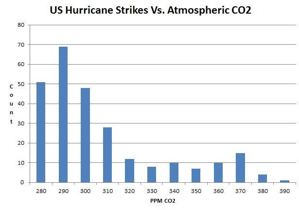
www.aoml.noaa.gov/hrd/hurdat/ushurrlist18512009.txt
Eighty-six percent of all US hurricanes occurred below Hansen’s safe level of 350 ppm.

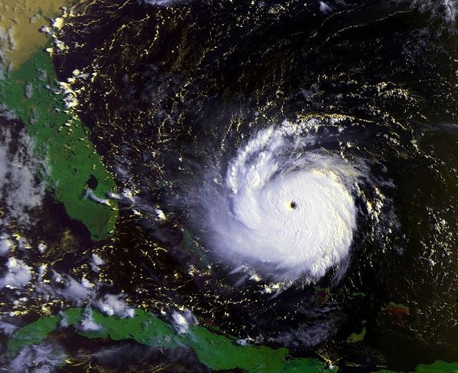
In August 1992, Hurricane Andrew struck Florida with 145 knot winds. It was the last category five hurricane to hit the US. The second highest land wind speeds (135 knots) were at the Indianola hurricane of 1886.
By contrast, the highest land wind speeds from Katrina were 110 knots
10/19/09
(METEOROLOGYNEWS.COM) When one thinks of Moscow in the winter, visions of snow-covered domes and Russians cloaked in fur coats often come to mind. But if the mayor of Moscow has his way, this winter will be much different. It will be a winter without snow. And recent observations of the skies over Moscow indicate he may have already tested out his plan…with some eye-catching results.
How did that work out for him?
A total of 392,000 cubic meters of snow have been removed from Moscow streets in the past 24 hours, a spokesman for the Russian capital’s authorities said Sunday. He said since the start of the winter, over 17 million cu m of snow have been cleared in Moscow. Meteorologists say February has seen record snowfalls in the Russian capital in the past 40 years.

Don’t mess with Mother Nature.
Someone named WOT has been arguing with me all afternoon, trying to claim that the heavy rain in Colorado has been over the mountains. So I overlaid precipitation map on the map of Colorado.
The heavy rain is east of the Continental Divide, over the plains. Denver is the red circle.

In 1988, Hansen forecast catastrophic warming. Today he said his forecasts had come true.
Temperatures are slightly lower so far this year than they were during the first half of 1988

