PIOMAS is a favorite tool of alarmists – and is complete garbage.
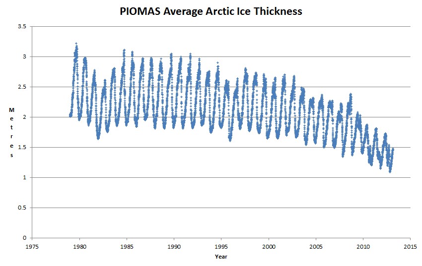
The graph below shows PIOMAS average ice thickness, calculated by dividing their modeled ice volume by Cryosphere Today ice area.
There is a fatal error with this data. Note how the ice used to gain more than a metre in thickness over the winter, but now it gains less than half that much.
It should be the other way around. With less thick ice cover now, the warmer water below is not as well insulated from the cold air above. This means that average ice thickness should increase more now during a winter than it did 30 years ago. Thick ice inhibits new ice formation, and thin ice facilitates it.
Temperatures have been running -35C in the Arctic this winter, and PIOMAS claims that less than half a metre of new ice has formed. That is just plain stupid. At those temperatures, half a metre of new ice would form in less than two weeks.
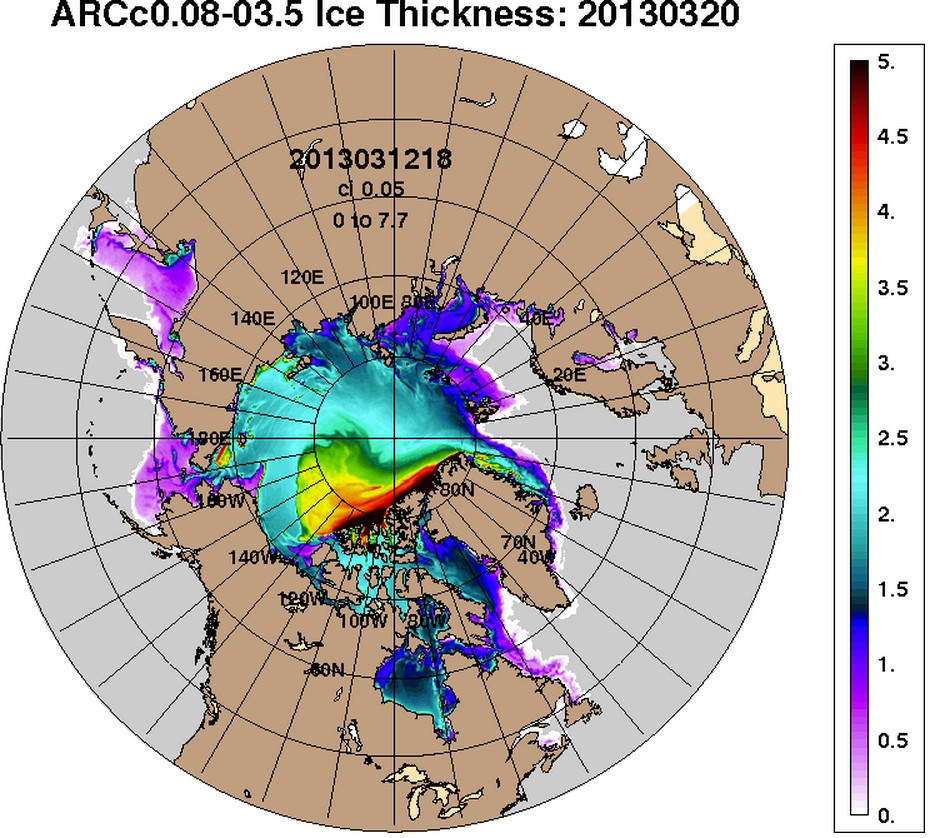
The US Navy shows that all of the ice in the Arctic Basin is thicker than PIOMAS average ice thickness, most of it much thicker.


The alarmists understand ice about as well as they understand clouds, and it is made worse by their willful ignorance
http://youtu.be/4nHcBFQlffI
MSTS Arctic Shipping Operations – 1950 to 1957
Watch how dirty the ice is. 1.43 min
The US Navy is also saying that ice is getting thinner. In fact, PIOMAS relies on the US Navy, as well as satellites, for their calculations.
Can you provide source for this contention?
Maslowski predicted ice-free in 2013.The clock is ticking for another brain-damaged prediction.
From the homepage of PIOMAS: “PIOMAS has been extensively validated through comparisons with observations from US-Navy submarines, oceanographic moorings, and satellites.”
Took me 30 seconds — tops — to find this info.
So if PIOMAS is extensively validated using all these tools, does Steve also contend that the US Navy and satellites are also flawed?
Anyone else see the logical inconsistency?
If someone says something, it must be true.
Pity that ICEsat stopped collecting actual volumetric data in 2009.
Pity that while waiting on ICEsat-2, the Navy’s “Ice bridge” contribution to PIOMAS is a nine-kilometer survey line.
Pity that PIOMAS’ model output is called “data”.
No thanks, I prefer to wait for ICEsat-2. Pity it wont launch until 2016
http://news.yahoo.com/nasa-selects-launch-services-icesat-2-mission-210700543.html
Note how the ice used to gain more than a metre in thickness over the winter, but now it gains less than half that much.
I.E. the large swings should be at the end.
Basic common sense.
In short order we should see it flatline:
http://toolstolife.com/images/content/flatline.jpg
Soon there will be no thickness at all…
Interesting pdf, includes IceBridge methodology and algorithms
http://nsidc.org/scicex/pdf/meetings/sac_jan2011/gardner_r-menge_airborne_ice_thickness_campaign.pdf