If he saw ‘rocky islands’ and much open water at the north pole he was in the wrong place. How did he navigate? Unlikely he had GPS – smartphones hadn’t been invented. In May it would be unlikely to be dark enough for astro navigation. If he saw the sun he might have been able to work out his latitude but I would like to see the computation from a sun sight.


Reblogged this on wwlee4411 and commented:
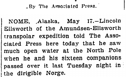
It’s happened before, and it will happen again.
If he saw ‘rocky islands’ and much open water at the north pole he was in the wrong place. How did he navigate? Unlikely he had GPS – smartphones hadn’t been invented. In May it would be unlikely to be dark enough for astro navigation. If he saw the sun he might have been able to work out his latitude but I would like to see the computation from a sun sight.
It could have been at the magnetic north pole, which would be in the Canadian archipelago at that time.
During May, it suggests that there was even more open water during the summer melt of that year, less ice.