Differentiating Global Warming Snow From Global Cooling Snow

Tamino says snow in Florida, Alabama and Mississippi is caused by unusually warm air.  I prepared the chart below to help readers to differentiate between global cooling high snow extent and global warming high snow extent.

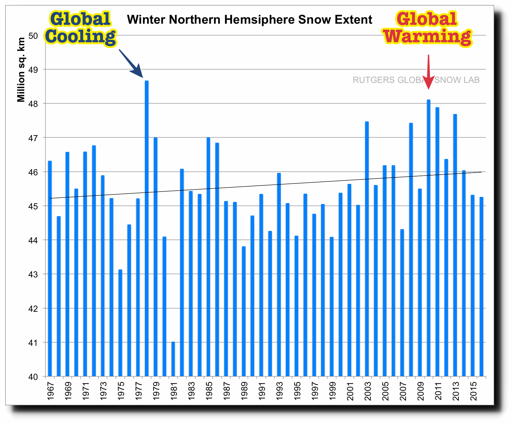
Rutgers University Climate Lab :: Global Snow Lab

Cold facts suggest a chilling trend

DESPITE THE MUCH heralded “greenhouse effect” that is said to be warming the Earth’s climate, average temperatures in Illinois have fallen signficantly in the last five decades analysis by state scientists shows.

From 1930 to 1983, the average temperature in the state fell 3.5 degrees Fahrenheit.

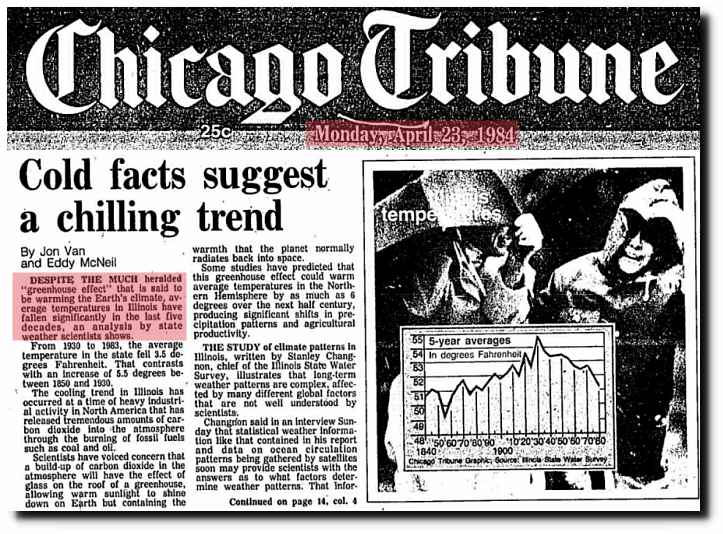
April 23, 1984 – Cold facts suggest a chilling trend

International Team of Specialists Finds No End in Sight to 30‐Year Cooling Trend in Northern Hemisphere – The New York Times

This entry was posted in Uncategorized. Bookmark the permalink.

25 Responses to Differentiating Global Warming Snow From Global Cooling Snow

  1. Steve Case says:

    …Illinois…From 1930 to 1983, the average temperature in the state fell 3.5 degrees Fahrenheit.

    I check things out, I just can’t help myself (-:

  2. Pingback: Differentiating Global Warming Snow From Global Cooling Snow - GraniteGrok — GraniteGrok

  3. AndyG55 says:

    UAH now out. Down to 0.23ºC anomaly

    On a yearly basis, 2016 was an INSIGNIFICANT 0.02ºC warmer than 1998.

    note, satellite measurement error is stated as +/- 0.1ºC.. (although probably rather more)

    The meaningless so-called surface data as fabricated by NOAA/GISS, probably has an error somewhere over +1ºC to -3ºC

    So 0.02ºC warming in 18 years…. WOW, scary ! :-)

    • Gail Combs says:

      The Snow News for the last week or so that we never hear about from the MSM.
      H/T to IceAgeNow which has also reported some of Tony’s articles recently.

      December 26, 2016 — Two children died on Saturday in a refugee camp in Iblib’s Harem City near the Turkish-Syrian border after their tents collapsed. Activists said that up to 70 tents (out of 200) had collapsed under accumulated snow.

      December 27, 2016 — Snow temporarily closes the Grapevine. The Grapevine is a very steep section of Interstate 5 about 80 miles north of Los Angeles, California. It ascends to Tejon Pass.

      December 28, 2016 — Record snowfall in Wyoming. Gillette’s record-setting white Christmas is keeping the city Public Works department busy as it tries to keep the roads clear while a combined 8 inches of snow fell Sunday and Monday. Meanwhile, the city of Riverton shattered its previous record of 6.8 inches (17 cm) of snow on Christmas Day, almost doubling the old record of “around” four inches. Snowfall records in Riverton began being cataloged in 1907.

      December 28, 2016 — Blizzard causes havoc in North Dakota. Shuts down roads. Closes Minot International Airport. Causes power outages across the state. I-94 was closed for days. The storm that began on Christmas Day dumped as much as 16.5 inches in Dickinson and 16 inches in Starkweather. With 12.5 inches of snow Bismarck had to switch from using motor graders that were getting stuck to slower-moving front-end loaders on city streets. Bob Morenski reported: The storm was nasty. I ended up with approximately 15 inches of snow and drifts up to 7 feet. We are already up to around 40 inches of snow for this winter.
      Snow forecast for Egypt, Turkey Pakistan, and Lebanon.

      December 29, 2016 In Istanbul, Turkey rain turned to snow. 5 centimeters in the coastal areas and 10-20 cm (4 to 8 inches) in the interior and higher sections. ATHENS: Snowfall in Greece’s capital city, where snowfall is rarely seen, surprised city dwellers. snow-covered roads 3-4 centimeters thick after about four hours of snowfall.

      December 30, 2016 — Snow twenty inches deep in Greece, and heavy snowfall in northern suburbs of Athens.

      December 31, 2016 — Heavy snowfall on Island of Crete. According to Cretapost, the snow has reached 30 centimeters. Turkey – Heavy snowfall in Ankara and Konya. Snow depth in Konya is 37 cm. Baker City, Oregon — snowfall record

      January 1, 2017–More than 3 inches of snow on Friday pushed the city of Billings Montana over its previous December snowfall record of 28.8 inches set in 1955, according to the National Weather Service in Billings.
      Intense cold and snow in southern Italy, snow even at low altitudes of Sicily, Calabria, Basilicata and Puglia.
      Bulgaria – Hundreds of people rescued from snowdrifts.

      January 3, 2017 — Record snowfall in Newfoundland. The 26 cm of snow that fell at the St. John’s airport Monday was a Jan. 2 record, busting the 1981 record of 21.6 cm. The day after the record snowfall, critics renewed their call for the Newfoundland and Labrador government to improve snow-clearing effort. [Trudeau is really going to like that one.]
      Turkey – Heavy snowfall closes roads to many villages.

      January 4, 2017 — India – Heavy snowfall closes Mughal road for third straight day. The historic Mughal road connects south Kashmir with Poonch in Pir Panjal area of Jammu. Continuous snowfall has hampered the road clearance work.
      Mission Ridge Ski Area in Washington State reported 39 inches (1 meter) of snowfall in 24 hours from Sunday to Monday.
      Snowing in New Zealand – In high summer!
      snow falling to 800 metres (2,400 ft) today in the South Island,” says reader, Greg Salmond. “Then yet another colder snap for the weekend with MORE snow.”
      Schools in E. Idaho (where it’s COLD) – close because it’s TOO cold. Idaho Falls School District 91 and Bonneville Joint School District 93 have announced that all schools will be closed Thursday due to the predicted cold weather.

    • Eric Simpson says:

      I hear that over 6 inches of rain hit the central coast of CA near San Simeon / Big Sur last night and today. 6 inches in 24 hours.

  4. Nicholas Schroeder says:

    References:

    Trenberth et al 2011jcli24 Figure 10

    This popular balance graphic and assorted variations are based on a power flux, W/m^2. A W is not energy, but energy over time, i.e. 3.4 Btu/eng h or 3.6 kJ/SI h. The 342 W/m^2 ISR is determined by spreading the average 1,368 W/m^2 solar irradiance/constant over the spherical ToA surface area. (1,368/4 =342) There is no consideration of the elliptical orbit (perihelion = 1,416 W/m^2 to aphelion = 1,323 W/m^2) or day or night or seasons or tropospheric thickness or energy diffusion due to oblique incidence, etc. This popular balance models the earth as a ball suspended in a hot fluid with heat/energy/power entering evenly over the entire ToA spherical surface. This is not even close to how the real earth energy balance works. Everybody uses it. Everybody should know better.

    An example of a real heat balance based on Btu/h follows. Basically (Incoming Solar Radiation spread over the cross sectional area) = (U*A*dT et. al. leaving the lit side perpendicular to the spherical surface ToA) + (U*A*dT et. al. leaving the dark side perpendicular to spherical surface area ToA) The atmosphere is just a simple HVAC/heat balance/insulation problem.

    http://earthobservatory.nasa.gov/IOTD/view.php?id=7373

    “Technically, there is no absolute dividing line between the Earth’s atmosphere and space, but for scientists studying the balance of incoming and outgoing energy on the Earth, it is conceptually useful to think of the altitude at about 100 kilometers above the Earth as the “top of the atmosphere.” The top of the atmosphere is the bottom line of Earth’s energy budget, the Grand Central Station of radiation. It is the place where solar energy (mostly visible light) enters the Earth system and where both reflected light and invisible, thermal radiation from the Sun-warmed Earth exit. The balance between incoming and outgoing energy at the top of the atmosphere determines the Earth’s average temperature. The ability of greenhouses gases to change the balance by reducing how much thermal energy exits is what global warming is all about.”

    ToA is 100 km or 62 miles. It is 68 miles between Denver and Colorado Springs. That’s not just thin, that’s ludicrous thin.

    The GHE/GHG loop as shown on Trenberth Figure 10 is made up of three main components: upwelling of 396 W/m^2 which has two parts: 63 W/m^2 and 333 W/m^2 and downwelling of 333 W/m^2.

    The 396 W/m^2 is determined by inserting 16 C or 279K in the S-B BB equation. This result produces 55 W/m^2 of power flux more than ISR entering ToA, an obvious violation of conservation of energy created out of nothing. That should have been a warning.

    ISR of 341 W/m^2 enter ToA, 102 W/m^2 are reflected by the albedo, leaving a net 239 W/m^2 entering ToA. 78 W/m^2 are absorbed by the atmosphere leaving 161 W/m^2 for the surface. To maintain the energy balance and steady temperature 160 W/m^2 rises from the surface (0.9 residual in ground) as 17 W/m^2 convection, 80 W/m^2 latent and 63 W/m^2 LWIR (S-B BB 183 K, -90 C or emissivity = .16) = 160 W/m^2. All of the graphic’s power fluxes are now present and accounted for. The remaining 333 W/m^2 are the spontaneous creation of an inappropriate application of the S-B BB equation violating conservation of energy.

    But let’s press on.

    The 333 W/m^2 upwelling/downwelling constitutes a 100% efficient perpetual energy loop violating thermodynamics. There is no net energy left at the surface to warm the earth and there is no net energy left in the troposphere to impact radiative balance at ToA.

    The 333 W/m^2, 97% of ISR, upwells into the troposphere where it is allegedly absorbed/trapped/blocked by a miniscule 0.04% of the atmosphere. That’s a significant heat load for such a tiny share of atmospheric molecules and they should all be hotter than two dollar pistols.

    Except they aren’t.

    The troposphere is cold, -40 C at 30,000 ft, 9 km, < -60 C at ToA. Depending on how one models the troposphere, average or layered from surface to ToA, the S-B BB equation for the tropospheric temperatures ranges from 150 to 250 W/m^2, a considerable, 45% to 75% of, shortfall from 333.

    (99% of the atmosphere is below 32 km where energy moves by convection/conduction/latent/radiation & where ideal S-B does not apply. Above 32 km the low molecular density does not allow for convection/conduction/latent and energy moves by S-B ideal radiation et. al.)

    But wait!

    The GHGs reradiate in all directions not just back to the surface. Say a statistical 33% makes it back to the surface that means 50 to 80 W/m^2. A longer way away from 333, 15% to 24% of.

    But wait!

    Because the troposphere is not ideal the S-B equation must consider emissivity. Nasif Nahle suggests CO2 emissivity could be around 0.1 or 5 to 8 W/m^2 re-radiated back to the surface. Light years from 333, 1.5% to 2.4% of.

    But wait!

    All of the above really doesn’t even matter since there is no net connection or influence between the 333 W/m^2 thermodynamically impossible loop and the radiative balance at ToA. Just erase this loop from the graphic and nothing else about the balance changes.

    BTW 7 of the 8 reanalyzed (i.e. water board the data till it gives up the right answer) data sets/models show more power flux leaving OLR than entering ASR ToA or atmospheric cooling. Trenberth was not happy. Obviously, those seven data sets/models have it completely wrong because there can’t possibly be any flaw in the GHE theory.

    The GHE greenhouse analogy not only doesn’t apply to the atmosphere, it doesn’t even apply to warming a real greenhouse. (“The Discovery of Global Warming” Spencer Weart) It’s the physical barrier of walls, glass, plastic that traps convective heat, not some kind of handwavium glassy transparent radiative thermal diode.

    The surface of the earth is warm for the same reason a heated house is warm in the winter: Q = U * A * dT, the energy flow/heat resisting blanket of the insulated walls. The composite thermal conductivity of that paper thin atmosphere, conduction, convection, latent, LWIR, resists the flow of energy, i.e. heat, from surface to ToA and that requires a temperature differential, 213 K ToA and 288 K surface = 75 C.
    The flow through a fluid heat exchanger requires a pressure drop. A voltage differential is needed to push current through a resistor. Same for the atmospheric blanket. A blanket works by Q = U * A * dT, not S-B BB. The atmosphere is just a basic HVAC system boundary analysis.

    Open for rebuttal. If you can explain how this upwelling/downwelling/”back” radiation actually works be certain to copy Jennifer Marohasy as she has posted a challenge for such an explanation.

  5. cdquarles says:

    Um, in power terms, UV and shorter wavelength light is about 10% of incoming solar radiation, visible about 35% and IR and longer 55%. Naturally, most of that is ‘near’ IR. Still that 5600K or so color temperature ball of glowing plasma puts out a lot of IR and longer. All stars do, else IR and microwave astronomy wouldn’t be possible. Old Sol is a G8 variable, by the way, if I am remembering correctly.

    • Gail Combs says:

      cdquarles, it is not the power of the wavelengths above visible light that is important, it is the amount of chemical interactions they induce in the atmosphere and how far they penetrate into the ocean.

      UV interacts with oxygen producing ozone and with nitrogen and oxygen producing a variety of NOx.

      In the ocean you get this: (Hope graph posts this time, my computer has gone wonky)

      • Gail Combs says:

        NASA: Solar Variability and Terrestrial Climate

        …Greg Kopp of the Laboratory for Atmospheric and Space Physics at the University of Colorado, pointed out that while the variations in luminosity over the 11-year solar cycle amount to only a tenth of a percent of the sun’s total output, such a small fraction is still important. “Even typical short term variations of 0.1% in incident irradiance exceed all other energy sources (such as natural radioactivity in Earth’s core) combined,” he says.

        Of particular importance is the sun’s extreme ultraviolet (EUV) radiation, which peaks during the years around solar maximum. Within the relatively narrow band of EUV wavelengths, the sun’s output varies not by a minuscule 0.1%, but by whopping factors of 10 or more. This can strongly affect the chemistry and thermal structure of the upper atmosphere….

        NASA rewrote their article that had % variation by wavelength catagory (EUV, UV, Vis, and IR) and wiped the chart… GRRRrrr.

        Solar Variability and Terrestrial Climate

        WUWT (2012) has this >a href=”https://wattsupwiththat.com/2012/02/29/giss-finally-concedes-a-significant-role-for-the-sun-in-climate/”>…This paper looks at hydrogen isotope proxy records over the past 6800 years and finds that the hydroclimate of the Northeastern U.S. is “highly sensitive” to solar activity…..

  6. Steve Clough says:

    This is from the winter of 2013/14 when Lake Ontario froze over. This happened again in 2014/15. The complete surface of Ontario was ice, as were most of the Great Lakes those years. Is this climate or just weather? I cannot say but if it were the other way around and Ontario never had ice, some would call it AGW. My $0.02.

Leave a Reply

Your email address will not be published. Required fields are marked *