
The same north winds which have been bringing record cold to Western Canada, Alaska and the US have also brought large amounts of 10+ foot thick ice to the Beaufort Sea, where temperatures remain far below normal.
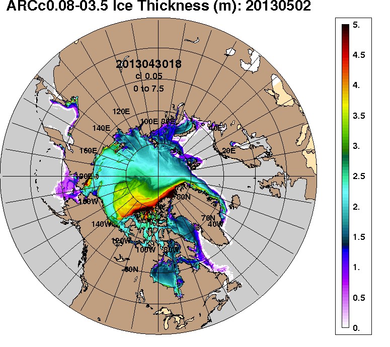
The same north winds which have been bringing record cold to Western Canada, Alaska and the US have also brought large amounts of 10+ foot thick ice to the Beaufort Sea, where temperatures remain far below normal.

“Dorothy dear. Close your eyes and click your heals together three times.
And say – There’s no ice in Nome, there’s no ice in Nome.”
And all the Arctic ice will disappear!!
I finally got to use a Wizard of Oz line after all these years. 😀
Happy days!
good one!
Neat, is a YOY comparision possible?
Gee, when will they pull out articles like this one:
http://www.alaskadispatch.com/article/new-study-arctic-ice-rotten
At what Northwest Passage route location (lat/long) are you referencing as blocked with 10+’ of ice? I’m at a loss to see the graphics at large details to make that determination. Bottom line – last year (2012) some 21 yachts and the WORLD cruise ship completed a Northwest Passage between Davis Strait Atlantic Arctic Circle and Bering Strait Pacific Arctic Circle. While I’m unaware at this time which is early in the yet open navigation season, which usually runs between July and October, I do know of several rowboats and kayaks which have announced they will be in the Arctic navigating between hamlets. Thanks for your information. Back to you Dorothy…
You have picked the time of year when Arctic ice is at its greatest extent to make your claim that the northwest passage will never open. Fine. Fact is, however, that oil tankers and freighters have been using it, for several weeks out of the year, every year for the past six years. Here you can see what the ice looks like in September, of 2007 ….
http://nsidc.org/cryosphere/quickfacts/seaice.html
(I personally have significant doubts about global warming in general and huge doubts about the anthropomorphic theory of causation … but there are simply too many people who select ONLY the evidence which supports their pre-conceived opinions ….)
One of the issues on the table is whether the open water is Canadian or International …the US is attempting to bully Canada the way it bullies everybody else, but the result of that may be that Canada will stop selling so much oil to the US, and that could be, well, funny ….
The Northwest Passage is blocked with 10 foot thick ice.