
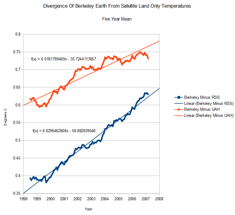
Satellite temperatures should be warming faster than surface temperatures, but they aren’t according to Berserkley Earth. Quite the opposite.
There were various theories floating around today about land only, RSS/UAH etc. The graph below should clear them up.
Berkeley Earth is diverging from UAH land temperatures at 1.8C/century, and from RSS land at 3.0C/century. Their data does not correlate with more accurate satellite data, and needs to be tossed in the dust bin of junk science.
www.woodfortrees.org/data/uah-land/from:1995.5/plot/rss-land/from:1995.5/plot/best/from:1995.5

When I look at Best I do not see anything the alarmists cloud scare even my kids with.
http://woodfortrees.org/plot/best-upper/from:1600/to:2014
Hadcrut, scarier…for kids.
http://woodfortrees.org/plot/hadcrut4gl/from:1600/to:2014
GIS does good at Halloween,
http://woodfortrees.org/plot/gistemp/from:1600/to:2014
Could it cloud their spelling ability?
There could be several explanations for the divergence. One could be that there is something important about the behaviour of the atmosphere climate scientists don’t yet understand. Or the Best methodology could be wrong. (“Wrong” in the sense that the combined errors in their methodology are greater than the trend they claim to measure.) Or it could be some combination of the two.
The Berserkly Earth data is wildly divergent from surface data reported in the 1970s., indicating that they likely cherry picked a bunch of stations which show warming.
The only thing Berkeley Earth demonstrated was fake skeptic Muller to be a fraudulent “skeptic”
He did more damage to the term “skeptic” than he did to science or Berkeley for that matter
It’s the behaviour of the climate scientists that is the explanation.
Berserkley Earth,,, lol,, good one
Let me just quote Mosher from Climate Etc again as it makes BEST’s data perfectly understandable.
” Steven Mosher | July 2, 2014 at 12:55 pm |
Amundsen doesnt Need to be fixed.
1. If you want to know what the temperature was.. USE THE RAW DATA.
2. if you want to know what wass EXPECTED, given all the data and a geostatistical model of climate… use the expected field.
pretty simple. First as a user you decide what you want to do.
Then you pick the data set.”
I do not understand the word “expected”. Do you?
Do you think Mosher does?
And where on earth is it getting hotter? It’s never where I am. And yet, until the latter part of the last decade, the temperartures where I was did conform with the general warming that was being reported. Then somehow my locale got disconnected from the global warming trends. (I suspect I’m not the only one having this experience.)
The averaged and adjusted data from “elsewhere” overrule the data from “anywhere and everywhere”.
Edit: “Their data does not correlate with more accurate satellite data, and needs to be tossed in the dust bin of junk science” — in the Mosh pit