
Not only is satellite sea level rise much faster than tide gauges, but it is also much faster than older satellite sea level.
Look how the University of Colorado has altered their data since 10 years ago.
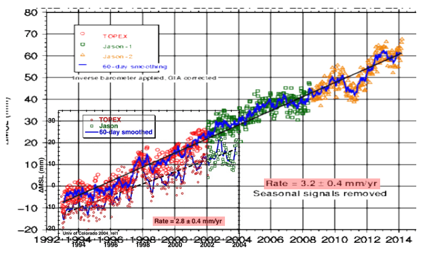
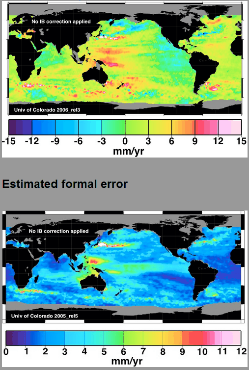
They achieve their bloated rise rates through the use of fake hot spot near the Philippines, where the error is as large or larger than the trend.
Sea level fraud in academia is just as big a problem as temperature fraud. Academics are rewarded for producing large numbers, not for being accurate.
h/t to Steve Case

Thank you for posting (-:
Thanks for reminding me. I hadn’t discussed this for a while.
gravity is stronger over sea floor mountains and volcanoes…which pulls water in and holds it…it also pulls satellites down a scooch…which enhances it
So could different and changing mantel density.
They can just about draw any slope they want. If the satellite instrumentation only has a precision of about 2 cm; how can CU possibly plot changes in mm?
The theory is the precision related errors are random so lot’s of measurements will cancel out. At least that’s how we did in electronic warfare.
Also, the Japanese hot spot appears to have an off the charts error.
it’s a theme park……
http://image.made-in-china.com/2f0j00KeNTPWQnZhku/Water-Slide-Hill-Side-WS-038-.jpg
The age of AGW is the age where government gave up all pretense of honesty.
So satellite data is unreliable for sea level monitoring. Yet you quote and cherry pick satellite data to prove your contentions. Using downward revised sea level numbers, Florida still disappears beneath the waves, just a half-century later.
Human interpretations of satellite sea level data are a complete joke. Don’t blame the satellites for the stupid people who process the data.
It is worse, Steve: Here’s the Ex-NASA Panel at the Heartland Climate Conference ICCC-9 – the first talk in the videoclip deals with satellite sea-levelI matters (and the rest is well worth watching too). The NASA old timers do know something about satellites!!!:
http://www.ustream.tv/recorded/49724714
One of the slides clearly shows the resolution difficulties and orbital positioning lack of precision.
Yes, I am the “old timer” presenter!
Thank you for your work.
Good job Tom. The major point I took away from that session (sorry, not yours) was the focus on the media. The media trumpeting of this non-problem remains the true problem. Over the past two decades it has amazed me how those reporting the ‘news’ appear to be the most clueless. IMO, that is not accidental. We all need to keep pressure on the media to focus on the empirical data, which not only reflects reality but could be presented in just as interesting format as the scare tactics used by alarmists. It wasn’t that long ago that individual media outlets would present alarmists as the sandwich board, crazy loons they are so it is not unprecedented for the media to present ‘the-we-are-doomed cult for what they are.
My interpretation of this major shift in the media portrayal of alarmists is tied directly to the media’s overall left-wing-extremist relationship that the media has embraced since the late 1960’s. The extreme left wing views anything harmful to a values-oriented society as something beneficial to their goal of power/control. When I read/listen to the major media outlets today, I see no difference between their views and those of the extreme-left. The extreme left is quite aware of the importance of retaining that relationship with the media. That is currently observed in witnessing the uproar by the extreme left by the possible purchase of Time Warner by Rupert Murdoch. The extreme left cannot win minds and hearts by debating the facts, rather only by proselytizing the public via their current close relationship with the media. That has to change or this “biggest scientific scam ever inflicted on the world” will continue.
amazing how a satellite can fall out of orbit…..and still show sea levels rising
..just imagine the amount of adjustments that have to be made
that top map shows a SL rise of 9 mm/year near Sydney NSW Australia.
This is absolute BS !!!!!!
Fort Denison in Sydney Harbour shows a SL rise of 0.65 mm/year
http://tidesandcurrents.noaa.gov/sltrends/sltrends_global_station.shtml?stnid=680-140
We do a surveying prac using hand held GPS,
They walk around the paddock recording Eastings and Northings for a could of dozen points around the irregular circumference then map the data to find the area.
and just for fun, we get them to record the elevation 🙂
The same spot can vary by up to a few metres when they do their reference point a second time, even though the position is usually within half a metre.
I sure hope SL measurements don’t use those same satellites !!!
errata : for a COUPLE of dozen points …..
I’m guessing their reported rise is for an unweighted average of the data.
However, the best unbiased estimator of the rise would be to weight all the values by 1 over the VARIANCE in the average. The variance is the std dev squared, so presumably the weighting would be 1/uncertainty^2. I’m guessing a completely different value would pop out with a proper weighting, and that value would of course be far lower.
It should be possible to do such a weighting just by doing a pixel analysis of their images.
-Scott
Claiming that the sea is “level” is ignorant at best. The ocean’s altitude is lower over the trenches and higher over the sea mounts.
“Sea level is generally used to refer to mean sea level (MSL), an average level for the surface of one or more of Earth’s oceans from which heights such as elevations may be measured. MSL is a type of vertical datum – a standardised geodetic reference point – that is used, for example, as a chart datum in cartography and marine navigation, or, in aviation, as the standard sea level at which atmospheric pressure is measured in order to calibrate altitude and, consequently, aircraft flight levels. A common and relatively straightforward mean sea-level standard is the midpoint between a mean low and mean high tide at a particular location.
“Sea levels can be affected by many factors and are known to have varied greatly over geological time scales. The careful measurement of variations in mean sea levels can offer information about climate change and has been interpreted as evidence supporting the view that the current rise in sea levels is an indicator of global warming.”
http://en.wikipedia.org/wiki/Sea_level
There is another factor affecting sea level–the level at the poles is different than at the equator. Much like the air ocean, gravity effects concentrate sea water at the equator.
“The average depth of the troposphere is approximately 17 km (11 mi) in the middle latitudes. It is deeper in the tropics, up to 20 km (12 mi), and shallower near the polar regions, approximately 7 km (4.3 mi) in winter. The lowest part of the troposphere, where friction with the Earth’s surface influences air flow, is the planetary boundary layer. This layer is typically a few hundred metres to 2 km (1.2 mi) deep depending on the landform and time of day. The border between the troposphere and stratosphere, called the tropopause, is a temperature inversion.”
http://en.wikipedia.org/wiki/Troposphere