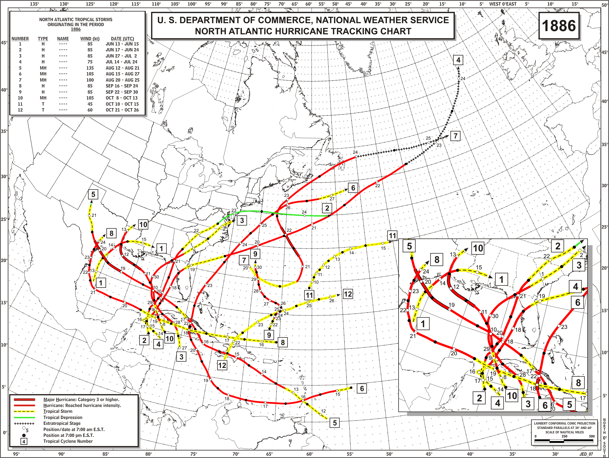
America’s busiest hurricane season occurred 130 years ago. In 1886, the US was hit by seven hurricanes, including two major hurricanes. Three locations in the US were hit by two hurricanes. Indianola and Sabine Pass, Texas were both destroyed.
Email Subscribe
Disrupting the Borg is expensive and time consuming!
-
Recent Posts
Recent Comments
- glen ferrier on No Correlation Between COVID Cases And Deaths
- Michael Moore on Science For Democrats
- Richard Tom on Five Years Since The End Of The World
- Oztruthseeker on Global Warming Update
- saveenergy on Five Years Since The End Of The Earth
Archives
- January 2021
- December 2020
- November 2020
- October 2020
- September 2020
- August 2020
- July 2020
- June 2020
- May 2020
- April 2020
- March 2020
- February 2020
- January 2020
- December 2019
- November 2019
- October 2019
- September 2019
- August 2019
- July 2019
- June 2019
- May 2019
- April 2019
- March 2019
- February 2019
- January 2019
- December 2018
- November 2018
- October 2018
- September 2018
- August 2018
- July 2018
- June 2018
- May 2018
- April 2018
- March 2018
- February 2018
- January 2018
- December 2017
- November 2017
- October 2017
- September 2017
- August 2017
- July 2017
- June 2017
- May 2017
- April 2017
- March 2017
- February 2017
- January 2017
- December 2016
- November 2016
- October 2016
- September 2016
- August 2016
- July 2016
- June 2016
- May 2016
- April 2016
- March 2016
- February 2016
- January 2016
- December 2015
- November 2015
- October 2015
- September 2015
- August 2015
- July 2015
- June 2015
- May 2015
- March 2015
- January 2015
I wonder just how many historic hurricanes went completely unnoticed, having spent their entire lives in mid ocean?
Or those that made landfall before it was discovered what they were….
I believe the currently accepted “model” prediction of the path of hurricane Matthew is wrong. It is already beginning to move more northerly. I believe it will not make landfall at all. It will just skirt up the coast several miles offshore, bringing a whole lot of rain up the coast (and a lot of wind too, of course). But I think their track is wrong. Seems they always have a tendency to error towards the west with these tracks. Remember the hurricane they tracked when Tony created the story about “betting on all horses in the race”? … yeah, this is the same damn thing.
My prediction, Matthew will now head due north until about NC and then curve straight out into the northern Atlantic, with the eye never actually making landfall.
Sorry, I meant South Carolina, not North Carolina … it is about that point where Matthew is going to take a hard right turn.
You may ask why I say this. Well, in Nashville Tennessee, today and tomorrow, we are to reach 87F (near 90) … that, in my view, tells me the hurricane is going to be pushing easterly much sooner than expected. If we were only in the 70’s, then I would say Matthew would make landfall.
You sir are a remarkable prognosticator! My brother lives in Tittusville, FL and was prepared for a direct hit. Sure enough, it veered to the north at the last minute, never making land directly.
Now, what are your thoughts on the stock market?
Lord are they hyping this storm….
The airport on New Providence, Nassau, which is only about 4 miles away from the West end…
….reported 92 mph winds with gusts
..and no, the eye did not go on shore
yep, just what I thought….
“The NHC forecast is slightly above
most of the guidance during the first 24 hours”
..Just enough to bump it up to a 4
They are desperate to claim a major made landfall….
Sunday, October 1st, 1893: – – – ” one of the worst natural disasters in the history of the United States occurred in Louisiana. The Great Storm, or the Hurricane of 1893 destroyed the tiny island of Cheniere Caminada, killing about half of its inhabitants.
According to church records, the population of Cheniere at the time of the storm was 1471, and of that number, 779 were killed. In all, the storm would claim over 2000 lives.” – – –
http://www.loyno.edu/~kchopin/new/culture/cheniere.html
The USA was booming, and cities popped up like mushrooms, with many stone buildings built to look like the austere 100-year-old building in cities back east. A big city was needed on the coast of Texas. “Indianola” was the front runner, but when it was wiped out Galveston became the place to invest. “Isaac’s Storm” is a good book about the boom, and the deadly bust when it too got clobbered by a hurricane.
After that, Houston looked a lot better, though inconveniently far inland.
That is the problem of building near water, Rivers and oceans FLOOD….
Gail, just for fun one time I looked for anyplace in this country that didn’t have some natural disaster….there isn’t one
wild fires, tornadoes, earthquakes, snow and ice storms, straight line winds, sinkholes, volcanoes, land and mud slides, droughts, floods…
Might as well live on the coast….it’s safer…at least you have a few days warning
Latitude,
You want to be in a tectonically stable area at least 50 to 100 feet above the 100 year flood level and far enough south that blizzards are not much of a problem. You also do not want to be in Tornado Alley.
Then all you have to do is worry about meteors.
OOPS….
The Mystery of the Carolina Bays
“…Most striking however, is that every single one is invariably aligned in almost exactly same direction – which has led some people to claim that they might be the result of a meteor impact. It would have to have been a pretty serious impact, as there are estimated to be over 500,000 of them…..”
SIGHHhhhh, It seems Life is Lethal and none of us are going to get out of it alive.
LOL…..exactly
I live on one of those rocks in the Caribbean…
I gets my goat when people talk about living on the coast….we are all completely surrounded by it down here
They look like oxbows … pretty typical of a meandering river system.
Birth is the number one cause of death.
Hey Stewart! yes, they do, in fact look rather like oxbows — but they really are different. There are also some similar bays in Nebraska and Kansas.
http://www.andywhiteanthropology.com/blog/the-carolina-bays-terrestrial-or-extraterrestrial
No, they do not look like oxbow lakes.
This is an Oxbow lake:
A RE-EVALUATION OF THE EXTRATERRESTRIAL ORIGIN OF THE CAROLINA BAYS*
That is one of the possible explanations. What ever caused them they are NOT oxbow lakes.
“Indianola was the front runner, but when it was wiped out Galveston became the place to invest.”
Wiped out twice…1875, then rebuilt and wiped out again in 1886. I have an old book somewhere about the aftermath of the 1886 storm and the survivors trying to make their way by foot to Victoria thirty or so miles away. Grisly stuff.
Charleston, SC has been devastated by Union troops during the Civil War, also by a 7.3 earthquake in 1886, multiple hurricanes and even by a tornado.
All long ago when CO2 levels were much safer!
My Mom lived through Hugo in 1989. Hugo was a a Cat 4 when it hit Charleston!
“Hurricane Hugo was a powerful Cape Verde-type hurricane that caused widespread damage and loss of life in the Leeward Islands, Puerto Rico, and the Southeast United States. It formed over the eastern Atlantic near the Cape Verde Islands on September 9, 1989. Hugo moved thousands of miles across the Atlantic, rapidly strengthening to briefly attain category 5 hurricane strength on its journey. It later crossed over Guadeloupe and St. Croix on September 17 and 18 as a category 4 hurricane. Weakening slightly more, it passed over Puerto Rico as a strong category 3 hurricane. Further weakening occurred several hours after re-emerging into the Atlantic, becoming downgraded to a category 2 hurricane. However, it re-strengthened into a category 4 hurricane before making landfall just slightly north of Charleston, on Sullivans Island September 21 with 135-mph sustained winds (gusts to more than 160-mph). It had devolved to a remnant low near Lake Erie by the next day.”
https://en.wikipedia.org/wiki/Hurricane_Hugo
By the way, I remember visiting about a year after Hugo, and the destruction in terms of downed trees was still quite evident.
Despite the devastation, Charleston is STILL standing today.
I used to chase hurricanes and did chase Hugo to Charleston. It was really biting off more than I could chew.
I parked right against a high rise hotel where we were staying, thinking that would protect the car. When the eye passed and it went dead calm, I saw that except for the windshield, nearly every other window in the car had blown out.
The hotel itself had major damage, as large chunks of concrete from the building were in the parking lot afterwards and numerous windows blew in. Obviously most rooms were totally flooded.
The wind at its peak sounded like thunder. Loud thunder!
I remember Hugo. My youngest son, now in the Navy, was born the same day as that hurricane. I passed through Charlotte, NC, on my way to a conference well after that storm hit. Charlotte was torn up pretty badly, and remember, Charlotte is well inland.
In 2004, Ivan passed west of my house, which was damaged some 170 miles inland; and hurricane force gusts were noted as far inland as Tuscaloosa, AL.
So what is the story with Wundermap, 43 mph from a buoy near to Freeport is windiest on map.
Matthew perhaps is not so Wunder-ful?? Hmmm…
Just watching a Fox News Hurricane forecast (2:45 pm) and Fox News “tends” to report “correctly” but their Meteorologist coughed something that makes absolutely no sense about Hurricane Matthew calling it a “Once in a 500 year Storm via its projected path” ?
So… ???
“Who” happened to be “homesteading” along the Southeast American coast/shoreline in say, the year 1516 (2016 – 500 = 1516) ?
In “1492”, Columbus sailed the ocean blue !
1516 – 1492 = 24 years !!
So did somehow Columbus note something like this just 24 years after He arrived in the Caribbean, or possibly was it the Native Indians, just who was there to start the 500 year clock ?
“Why” do people (Meteorologists) say such stupid ass stuff like this ???
Every “100” year event, definitely possible, “200” year event, America had become a Nation by then, “300” year event, could have happened but who would have survived the event/Storm to document it ? ! ?
“500” year event, you gotta be kidding, you can’t be serious ?????
That’s what the [Left] does all-the-time !
They just make up shit and then call it fact/reality !!!!!
What are you doing Fox News, stay away from MSLSD…
Because MSLSD is for “complete” NUT-JOBS !
Fox News is not the old Fox news. For one thing it is owned by the foreigners, Aussie Murdoch and his buddy a Saudi Prince who are pro-Open borders and donated generously to Hitlery’s campaign.
Roger Ailes got kicked off Fox News thanks to Megyn Kelly. She was paid off for attacking Trump and Ailes with a very generous book deal. — Megyn Kelly Closes In On $10+ Million Book Deal
When Ailes got kicked out Murdoch turned it over to his openly globalist/socialist sons. There is nothing ‘conservative’ about Fox. It does not even deserve the name ‘Controlled Opposition’ any more.
Great point! I only question when was FoxNews “the old FoxNews”? Current ownership has been in place for quite a while.
Argh, bad use of statistics. What they should say is that a ‘500 year’ event is an event that has a 1 in 500 chance of occurring in any one year. That is, the event has a success probability of 0.2% (2/1000). Likewise a ‘200 year event’ has odds of 0.5% (5/1000) or a ‘100 year event’ has odds of 1%.
Not too far from Indianola is a statue commemorating where La Salle supposedly came ashore in Texas at Matagorda Bay. In 1961, Hurricane Carla also came ashore nearby and moved the multi-ton granite statue 1/2 inch off its base…a true testament to the power of category 4 storms.
Looking at the latest radar out of Miami, it looks like Matthew is starting to fall apart. The eye wall has expanded and is no longer is even closed off. I know what Hugo and Andrew looked like on radar and Matthew is no Hugo or Andrew. It frankly looks like a mess.
My prediction, no NWS station on land will record sustained 80 mph winds.
Andy…the outer eye wall is folding in….eye wall replacement
Wind speeds on NBDC stations are showing nothing more than 50mph’s winds at the moment. This is not a Cat 4. Earthnullschool
is showing the same surface winds.
According to Drudge, Hilliary, blames hurricanes on climate change.
http://drudgereport.com/
According to Drudge, The deplorables are starting to wonder if govt has been lying to them about Hurricane Matthew intensity to make exaggerated point on climate, He tweeted.
http://www.popsci.com/dont-take-weather-advice-from-matt-drudge
Haha
Politicians love disasters to gain more power, whatever party they are. The bigger the better. Remember they would even sell their family if beneficial to their career. They all want to be the master of the universe.
They only forget that they too are just tools in the hands of the elite and therefore replaceable.
Politicians are the ones with their rearends hanging in the breeze when the rabble decides it is time to haul out Madame Guillotine again.
What has the elite in a tizzy is now a days the rabble has seen passed the politicians to the puppet masters.
I wouldn’t want to be a reporter either in a SHF situation. They are a MUCH easier target and the anger against them is higher than towards a politician that you expect to be dishonest.
NWS Medford tweeted this out on Oct 4:
https://pbs.twimg.com/media/CuJARn3UsAAc8Cg.jpg:large
Showing a Cat 4 hurricane passing directly over a buoy, with 80kt max wind gusts. When asked, they claimed it was sampling gaps that missed the winds…don’t know the sampling rate, but seems pretty far fetched for a storm moving as slow as Matthew was then.
By the way, a lot of rebuilding to do in Haiti. Maybe they should call the Clinton Foundation.
No just the Clintons themselves. I am sure the Haitians could arrange an appropriate accident….
“NEWS FLASH” !
Hurricane Andrew, oops I meant Hurricane Matthew’s “Eye”
wall just increased from 17 miles to “80” miles in diameter, which means that the “Hurricane” is “intensifieng !
What a dangerous Storm !!!
On the “Weather Channel”, winds are “Howling”,
Wind Gusts up to “35” mph
No need to hold up stop signs ?
When winds exceed “35” mph, no need to hold up stop signs ????
Lots of 2,000,000 million evacuated,,,,
Anybody ever seen “Andrew” ?
WEAK !
?