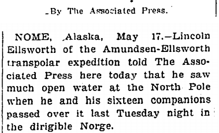
h/t to Jimbo
Disrupting the Borg is expensive and time consuming!
Google Search
-
Recent Posts
- “Why Do You Resist?”
- Climate Attribution Model
- Fact Checking NASA
- Fact Checking Grok
- Fact Checking The New York Times
- New Visitech Features
- Ice-Free Arctic By 2014
- Debt-Free US Treasury Forecast
- Analyzing Big City Crime (Part 2)
- Analyzing Big City Crime
- UK Migration Caused By Global Warming
- Climate Attribution In Greece
- “Brown: ’50 days to save world'”
- The Catastrophic Influence of Bovine Methane Emissions on Extraterrestrial Climate Patterns
- Posting On X
- Seventeen Years Of Fun
- The Importance Of Good Tools
- Temperature Shifts At Blue Hill, MA
- CO2²
- Time Of Observation Bias
- Climate Scamming For Profit
- Climate Scamming For Profit
- Back To The Future
- “records going back to 1961”
- Analyzing Rainfall At Asheville
Recent Comments
- arn on Climate Attribution Model
- Bob G on Climate Attribution Model
- Bob G on Climate Attribution Model
- Bob G on Climate Attribution Model
- Bob G on Climate Attribution Model
- John Francis on Ice-Free Arctic By 2014
- Bob G on Climate Attribution Model
- Bob G on Climate Attribution Model
- Bob G on Climate Attribution Model
- Robertvd on “Why Do You Resist?”


Reblogged this on wwlee4411 and commented:
It’s happened before, and it will happen again.
If he saw ‘rocky islands’ and much open water at the north pole he was in the wrong place. How did he navigate? Unlikely he had GPS – smartphones hadn’t been invented. In May it would be unlikely to be dark enough for astro navigation. If he saw the sun he might have been able to work out his latitude but I would like to see the computation from a sun sight.
It could have been at the magnetic north pole, which would be in the Canadian archipelago at that time.
During May, it suggests that there was even more open water during the summer melt of that year, less ice.