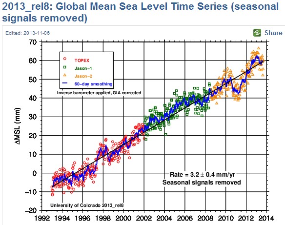
Climate geniuses tell us that sea level was rising about 1.8 mm/year until 1993, when it suddenly shifted to 3.2 mm/year. This amazing transition occurred exactly when satellites were launched to monitor sea level.
The only plausible explanation for a certified Mannian climate genius, is that satellites are massively affecting sea level.


Infographic of data deletion by the Space Age nuclear family of Jimmy Simpson:
http://i4.minus.com/idFxzI.jpg
NASA to this very day deletes the last decade of tide gauge data from their web site, criminally. Space is a toxic desert. Let’s send those “proud Muslims” there in 2016.
As a remote sensing student, we were first taught that in situ observations always trump satellites, and to use real ground observations to calibrate why we witnessed from afar.
Gator, of course they use ground observations
http://www.aviso.oceanobs.com/en/calval/latest-results/in-situ-2011-validation.html
NikfromNYC
How convenient to end the graph mid 2011
Bob, I have seen the gauges they cherry pick, gauges with extreme subsidence. Peddle you snake oil elsewhere.
Gator, here is a map of the tide gauges linked to the satallites:
http://www.aviso.oceanobs.com/en/calval/in-situ-calibration-and-validation/in-situ-global-statistics.html
Are you telling me that they all have ‘extreme subsidence?’ Show us your link to the contrary.
Can you show me the gauges that are NOT subsiding? Coastline subsidence is a known factor.
“Only tide gauges which are well correlated with all altimeter data (correlation > 0.7) are considered to be reliable and usable for detecting potential drifts or jumps in altimeter time series, or in the estimate of the quality of new altimeter standards.”
Nicely done Bob!
Coincidentally, that’s just how Briffa picks his trees. Ignore the trees and tide gauges that don’t correlate with our desired outcome, then choose the remainder to prove our predetermined conclusions. Frankenscience
That’s when I made it, Bobby.
I can see that Earth is in crisis. One more satellite on the same side, and Earth could tip over!
Then all the water will fall off and we’ll really be screwed!
signed, Hank Johnson
Its easier to rig one election computer than it is to stuff a thousand ballot boxes.
It is easier to ‘adjust’ the data from one satellite than a thousand tide gauges.
I say nothing about the veracity of the satellite data except that recent papers on tide gauge data agree an expected increase of about 120-150 mm during the rest of this century, or about 1.5 mm/yr, less than half of the satellite number.
Please put out a summary of the inherent errors in trying to use satellites hundreds of miles above the Earth to measure elevation changes of ocean surfaces at mm scales (Hint: the precision/accuracy in on the order of +-5cm)