
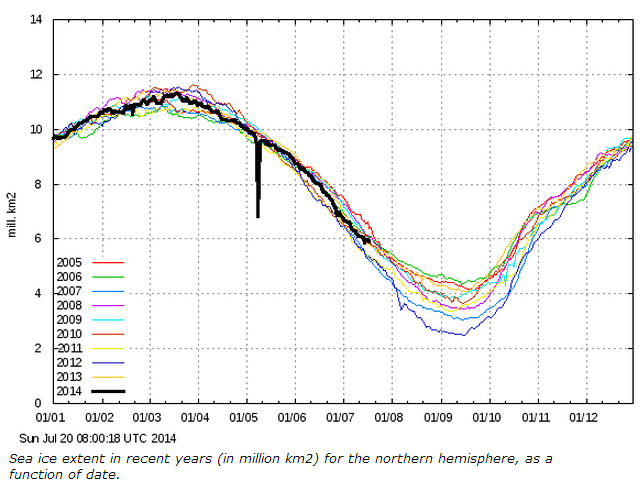
2006 had the highest minimum Arctic sea ice extent of the last decade, and 2014 is tracking it quite closely, with very little change in ice extent over the past 10 days.
 COI | Centre for Ocean and Ice | Danmarks Meteorologiske Institut
2006 had the highest minimum Arctic sea ice extent of the last decade, and 2014 is tracking it quite closely, with very little change in ice extent over the past 10 days.
COI | Centre for Ocean and Ice | Danmarks Meteorologiske Institut

Good job you’re posting these updates as for some reason I can’t seem to find any on the BBC or Guardian sites.
I don’t know about the Guardian’s view but the BBC recently put out a missive about non consensus, non scientists commenting on climate matters.
The key from it is –
In other words no change from the ‘Auntie knows best’ stance that they have alway had.
from http://www.bishop-hill.net/blog/2014/7/20/bbc-and-nigel-lawson.html
If you compare the “area” graphs with the “extent” graphs, you get an idea if the ice is densely packed with little water showing or loosely packed, with a lot of water between the bergs. This year it is densely packed, up around 80%, which is high (unless it is winter.) That means there is a lot of ice for the wind to spread into open water, if the wind is tight. I think this might happen in the open waters of the Laptev Sea next week, which might lead to the “extent” flat-lining, or showing an up-tick.
http://sunriseswansong.wordpress.com/2014/07/16/arctic-sea-ice-melt-flat-lining-death-spiral/
Great point. It’s NOT ‘rotten’ ice, quite the opposite, it’s thick strong ice that’s got staying or spreading power. We are going to have a lot of ice. Get the champagne ready!
A right turn is in full swing:
http://arctic-roos.org/observations/satellite-data/sea-ice/observation_images/ssmi_ice_ext.png
Current 10 AM local time temperature at Barrow is 33 degrees. Reggie needs a much larger blowtorch, as his current one is way too small. Even Viagra will do him very little good at this point.
The next 7-10 days looks to have a persistent cyclone over the western arctic basin with smaller areas of low pressure gyrating around the overall movement of the main cyclone. This will basically keep clouds, cold air and a mean west wind vector over the ice edge resulting in very little melt till August. In fact, there should be some further compaction of the ice along the Canadian archipelago and ice blow in to close some of the open water in the McClure Strait. Caleb also made the astute observation that some of the more densely packed ice will drift into the Laptev Sea next week. This is also a possibility but because of the Taymyr peninsula there’s a southern limit to how much of the Laptev could potentially see ice return. There should be some closure of the area of open water toward the New Siberian Islands, however, and a bit of ice drift in from the Kara Sea, though that region should see continued melting/compaction, with most of the losses coming from there and whatever remains in Hudson Bay.
Astute observations. Thanks.
The Canadian “JEM” model shows a lot of wiggling in that west-wind vector around the persistent low, which yet again comes close to sitting atop the Pole. At points it blows west across the top of the Laptev Sea, but at other times it blows straight down into it. Of course, that could all change the next time they run the model. However I’ll bet a nickle there is more ice in the Laptev Sea by Friday. (A safe bet, as there is nearly none, now.)
I think there is so little ice in the Laptev Sea because much of last winter a cross-polar-flow was pushing it north and across the Pole to build those mountainous pressure-ridges that gave the polar adventurers such problems in close to the Canadian Archipelago last April. At times there was open water briefly showing up in the Laptev Sea even in the dead of winter, swiftly chilled and refrozen by cruel minus-fifty air blowing off Siberia. Though needing to constantly replace the ice-cover may have meant the ice was thin in the spring, I bet that water beneath was far colder.
Yes, last winter was a very very good winter for ice growth in the arctic basin. I think many will come to realize that once we’re getting into the stretch run toward the minimum around Sept. 10th (my early call on minimum date). The ice grew more compact and the drift pattern was anti-cyclonic till late winter when it shifted cyclonic. But the center of cyclonic turning was in the eastern basin, closer to Siberia, and not the western basin between Canada and the North Pole. This kept ice in the basin and halted transport out of the Fram Strait. This is a key development for it moves ice toward the Barents and Kara Seas. We’re essentially witnessing the rebuilding of MYI in these areas which will, in turn, lead to a long-term period of the arctic gaining ice, especially as the AMO begins its decent toward a cooler state.
It’s also worth noting that the Northwest Passage is still shorefast ice. With only 6 weeks left of a declining melting season there’s no chance of this area opening up this year.