
Anthony Watts did a story about a long time weather observer :
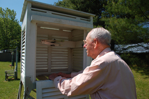
When Richard G. Hendrickson (seen at right) logged his first weather observation for the U.S. Weather Bureau, the precursor to NOAA’s National Weather Service, Herbert Hoover occupied the White House. Since then the Bridgehampton, New York, farmer has filed twice daily reports, tallying more than 150,000 individual weather observations – playing a critical role in building our nation’s climate history.
Here is some more detail about the bizarro adjustments being done by USHCN.
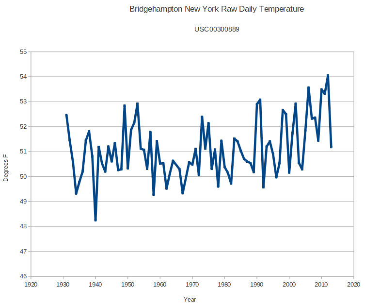
The station has daily data going back to August 1930, yet USHCN has adjusted data going back to 1893. They have fabricated non-existent data for 37 years.
Anthony shows this GISS graph, and wonders why Gavin hasn’t updated the data for two years.
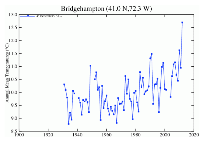
Anthony is right to be concerned – the temperature has plummeted to close to the mean since NASA quit updating. After the 2014 data is registered, it will show one of the coldest years on record.
But it gets much worse – USHCN is massively cooling the past, and warming the present in Bridgehampton, NY – by a total of 2 degrees.
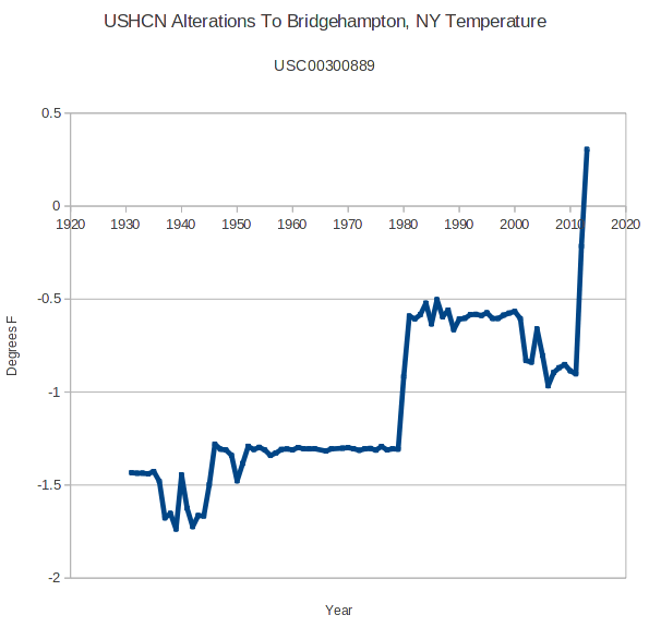
Richard G. Hendrickson has been taking twice daily readings, yet USHCN is doing a TOBS adjustment of 0.4-0.8 degrees cooling the past. This adjustment is nonsensical given that he was reading the thermometer twice a day – which eliminates any chance of TOBS issues.
Anthony is right to wonder about the adjustments on this station. They are complete garbage and just one example of how NOAA and NASA massively corrupt the US temperature record to create the appearance of non-existent warming.
Bridgehampton is currently having their eighth coldest year on record, and coldest in 22 years.
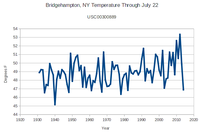
The data looks nothing like the GISS graph. Other than a temporary spike after the mid-1990s – there has been very little warming in Bridgehampton.

Criminals.
As you just tweeted, Steven:
Bridgehamptongate!
It would be most interesting to interview the exact individual who made the adjustments. Perhaps an FOI request on NCDC/NOAA to determine who adjusted the Bridgehampton readings?
Check the WUWT link. Anthony did interview him.
Interesting nugget in this post on WUWT –
http://wattsupwiththat.com/2014/07/23/i-wonder-how-this-dedicated-weather-observer-feels-about-having-his-readings-adjusted-by-ncdc/#comment-1693316
A question for Tony based on the quote below. Is it possible that changes is the precision of Latitude/Longitude measurement for a given site initiate a “station move” in the adjustment algorithm? If so, then millions of records have been erroneously marked as “station move” with an associated erroneous adjustment.
I seems possible there have been a multitude of changes in the precision over the decades as GPS came online, satellite changes, etc, producing phantom station moves and phantom adjustments.
Greg Goodman says:
July 24, 2014 at 12:44 am
https://www.ncdc.noaa.gov/homr/#ncdcstnid=10500064&tab=MSHR
I see two station ‘moves’ that appear to be nothing more than a change in the precision of the way the lon / lat data is logged.
Was the 59ft to 60ft ( above sea level ) change a physical move or not? It seems to coincide with some administrative changes at the same time.
I wouldn’t say ‘phantom adjustments’…they were ‘real’, but the reasons for making them would be phantoms.
re: Tom In Indy says July 24, 2014 at 2:13 pm
…
I[t] seems possible there have been a multitude of changes in the precision over the decades as GPS came online, satellite changes, etc, producing phantom station moves and phantom adjustments.
Hmmm … good question … What would *you* use prior to the advent of GPS to obtain a lon/lat coordinate pair?
A star (sextant) siting?
Or a (more accurate) USGS 7 1/2 minute topo map easily available from the USGS?
They are still available, BTW: http://www.usgs.gov/pubprod/
(I addressed this a little further below, BTW.)
The errors creep into determining Long/Lat from topo maps owing to the hand-marked-up features like roads and creeks and human structures like houses that change, or burn down or the original errors from the photogrammetry techniques used in detailing the topo maps.
http://en.wikipedia.org/wiki/Photogrammetry
.
There is nothing in the raw data which looks remotely like a discontinuity, and thus no excuse for adjusting for one.
re: mjc says July 24, 2014 at 2:20 pm
I wouldn’t say ‘phantom adjustments’…they were ‘real’, but the reasons for making them would be phantoms.
It really is true; everyone ‘operates’ from the present knowledge baseline with no ‘reversion’ or knowledge of the past.
This explains a lot in the thinking of ‘man’ in modern society, and also why global warming has been able to be ‘sold’ to so many ppl; no knowledge of the past or practices in the past or how life itself was ‘lived’ in the past given conditions.
It’s like, everyone ‘operates’ only with the knowledge from (roughly) the ‘day they were born’. Nothing preceding exists.
.
Presumably, all geographic positions are now based on the WGS84 datum. Prior to that NAD83 was used and prior to that NAD27 was used. There may be tens of meters difference between a NAD27 position and a WGS84 position, mainly because a different spheroid was used to model the earth. Does station metadata include the datum used for the geographical position? Does USHCN understand that a change of lat/long may simply reflect a change of geodetic datum?
Does USHCN understand that a change of lat/long may simply reflect a change of geodetic datum?
Probably not. For those interested, conversions btw NAD 27 to NAD 83 and vice versa can be done individually or via a file input here:
http://www.ngs.noaa.gov/cgi-bin/nadcon.prl
Regarding WGS84 and NAD83, if differences of a meter or two can be ignored (GPS is not accurate without either differential corrections or a survey conducted over some number of hours for more than 20 meters, per spec, but ultimately seems to be much better than that on the average regardless) then the two can be regarded as the same.
Decimal to DMS format can be handily done here:
http://transition.fcc.gov/mb/audio/bickel/DDDMMSS-decimal.html
.
Interesting to see the map in datum shifts between NAD27 and NAD83 here:
http://en.wikipedia.org/wiki/North_American_Datum#Comparisons_Between_NAD27_and_NAD83
The difference due to datum shifts could be 30 to 35 meters in NY. Bigger errors are created, though by the ‘manual’ interpolation of lat and long between the ‘hash marks’ on the topo map normally performed using a ruler (marked off in degrees/m/sec) designed for that purpose, plus the errors in the maps themselves (some of those dating back to early 1900s.)
.
I just re-read the article as I could not remember Anthony mentioning an interview with the person who made the adjustments. I still can’t see it – perhaps I have comprehension blindness.
USHCN to Hendrickson: You are clearly a moron and do not know what you’re doing
Hendrickson to USHCN: Look who’s talking.
Seriously: this should be emblazened across Obama’s head as an example of how he is being duped.
I doubt the laughingstock-in-chief is much concerned about being “duped”. He does want a carbon tax after all…..
I think the laughingstock-in-chief and his merry band of czars are the ones pushing for data, any data, even creatively adjusted and faked data to present a global warming as a crisis to distract from the many fumbles, bumbles, and scandals originating from the current administration….
Some of the scandals:
AP reporters wiretapped
Fast & Furious gunrunning
NSA over-reaches
EPA Abuses
The empress’s connections with Obamacare website contractors
Solyndra and all the other bankrupt, politically-connected green-energy grantees.
IRS and the administration’s enemies list
Obamacare legislation winners and losers
Benghazi,
VA Abuses
Bergdahl & Afghan prisoner releases
The well orchestrated flood of immigrant children to force the immigration issue…
(listing those makes me a racist according to defenders the administration)
Whipping-up a frenzy of publicity about how serious global warming is, looks to be a distraction maneuver.
Fortunately, the current administration’s track record with truth and accuracy automatically discredits anything they promote. Thus, I personally think that the laughingstock-in-chief is a prime wooden stake through the heart of CAGW.
The exposure of the data tampering is the icing on cake.
Makes Tricky Dick look like the epitome of virtue and honesty by comparison.
With Tricky Dick it was repub on democrat ‘crime’; with CAGW it is an assault on humanity and the most successful economic system to date.
Makes you wonder how Nick and company are going to justify the adjustments.
He is doing his racehorse BEST over at WUWT. Same tactic of just saying something that sounds good but really means nothing.
That’s got to be ‘attention whore’ behavior; to repeatedly defend the indefensible that way.
Jim,
From observing the behavior for years, I think it goes beyond attention. Based on the prolific nature of the posts, the never ending defenses no matter how blatant the offense, etc. indicates to me that there may be a vested interest being supported. It may even be a paid position. Who has that kind of time to devote to defending pure crap?
He seems to put too much ‘heart’ in it just to be a vested interest; he literally lives for the attention, and will contest or argue the damnedest things to get that attention. Nothing else going on in his life …
My $0.02 anyway.
I think it is both. If I am not mistaken, Racehorse Nick worked for CSIRO in some capacity. He’s a true believer in a false religion, I say.
He is a true believer, with a large helping of constructing sentences that Steve Mc call “watch the pea”, then punching in with an AHA on an inane point that you might have made. The conversation will not move on until you repent. A wasted talent (sigh)
Richard ‘Racehorse’ Haynes doesn’t deserve such company:
http://www.abajournal.com/mobile/mag_article/richard_racehorse_haynes
Reading Nick, I am reminded of this portion of OPM (start about a minute into it):
http://youtu.be/62kxPyNZF3Q
The biggest claim is a “station move”. Which on the face of it is ridiculously stupid. The station wasn’t moved, technology to locate where it WAS got better. They didn’t have Garmin GPS back in 1985… And if the move occurred as they state, it would have either moved OFF this gentleman’s property, or it would have originally been located in a neighbors back yard and moved ON to his property. Neither is likely. I went through some of the hand written records from this station after this story posted. They are beautiful. I chose 2003, because every month in the USHCN record has an “E” tag for “estimated”. There was not one missing day that I saw…
.
Prior to hand-held GPS ‘receivers’ people e.g. engineers (civil engs and radio engs like myself in the 1990’s) used “USGS 7 1/2 minute topo maps” to determine long/lat coordinate pairs for FCC filings and FAA ‘tower studies’ near airports (and also for propagation studies) … location determination using these techniques result in errors about comparable to SA (Selective Availability) which is on the order of 300 to 500 feet. I think the ‘error’ or move being discussed was within this range.
Two relevant posts I made on that subject on WUWT:
– – – – – – –
_Jim says July 24, 2014 at 5:44 am
re: lee July 24, 2014 at 12:40 am
No one here has probably used the old-timey paper USGS 7 1/2 minute topographical maps to ‘take’ long and lat measurements; I have, and it is NOT surprising that with the advent of GPS a more accurate position was recorded.
Too many ppl today with only a lot of ‘desk’ experience, as poster ‘jim’ [in the WUWT thread] above alludes to.
.
– – – – – – – – –
_Jim says July 24, 2014 at 6:02 am
re: lee on July 24, 2014 at 12:40 am
…The first GPS satellite was launched in 1978 …
A brief side note: We had at the time 3 (three) sats in orbit in 1978 as the fledgling GPS NAVSTAR project was still in its infancy, the hardware of the day still being developed at several companies in the US.
Yuma Proving Grounds had a ‘ground range’ where aircraft could fly patterns while taking data on new hardware before the full constellation of sats was in place. I was with TI at the time working on their HDUE (High Dynamic User Equipment), performing ‘factory test’ of product and providing technical support to personnel performing environmental testing (shake and bake) on the HDUE ‘boxes’.
Later, in the 90?s while at MetroCel Cellular (to be bought by ATT WS) I made use of GPS and USGS topo maps to do cellular system planning and site selection; with the GPS sats having SA (Selective Availability) turned on one’s position on earth could be seen to ‘drift’ +-300 feet or more as SA was meant to ‘dither’ the computed position about a centroid point. Not until sometime in Pres. Clinton’s term (after May 1, 2000) SA was turned off, resulting in a more accurate, instantaneous GPS position report.
SA – http://www.gps.gov/systems/gps/modernization/sa/faq/
GPS – http://en.wikipedia.org/wiki/Global_Positioning_System
– – – – – – –
Interesting. I was at YPG in 1977. One of my projects was to photograph and film the boxes that were set up on several hills as part of the project.
Small world eh? About years 13 years later I cubed with a guy who had been out there on the ground at Yuma, he was working ‘field service’ out there for TI. We cubed together at TI’s (at the time) GaAs Facility (a ‘front end’ that did uWave MMICS and discrete GaAs FETs most often used for TVRO/DBS consumer sat equipment) in the 1990s.
Pat Shipley was his name – the guy who was a YPG
I was going to post this over on WUWT, but thought better of it…
Slightly, OT, but related to ‘moving location’ annecdote…
The house I live in was built sometime in the early to mid 1980s (about 10 yrs before my father-in-law bought it in 1992). From that time until a few months ago, the physical address was considered to be at the end of a 1/4 mile long driveway, at, roughly, the mailbox. A few months ago, the county I live in went ‘live’ with an enhanced 911 system…including new physical addresses for all county properties, based on GPS locations near the main entrance to the domicile/main building on the property.
So, according to the official documentation…I moved 1/4 mile.
I was wondering how bad the adjustments would be to this guys poor station; now I know. 🙁
Reading the article you can see show there might be some warming at the temperature site at the trees and bushes grew up alongside the Stevenson screen, blocking the wind. I don’t see the adjustments for the siting errors which would lower the last half of the record and which could be justified.
smoking gun
This is more like finding the bullet used in the crime.
THis is a posting that could have had an MSM effect. I would have made it a sticky post for MSM to finally see it.
Going way back, Long Island NY was very rural. It was mostly farms particularly potatoe farms.
Then came the Long Island Expressway and lots of shopping malls!
Tom In Indy says:
July 24, 2014 at 2:13 pm
I seems possible there have been a multitude of changes in the precision over the decades as GPS came online, satellite changes, etc, producing phantom station moves and phantom adjustments.
====================
The Ultimate: my son and I went to Four Corners in 2010. It was CLOSED (!). I subsequently found that it was being MOVED. Crummy kids with their GPSs had told their mommies, “Hey, this isn’t it, it’s over that way!” For decades, people laid on the monument, being in 4 different states at the same time. Not really, they were in New Mexico.
Rats. That means I’l have to go back … (went what seems like a long time before, cell phones even; used 2 meters (146 MHz) and contacts with locals to help navigate)
I just found out that according to the coordinates of the station, that the local river gauge/weather station is in a barn, on top of a hill, 1/4 mile from the river.
That is an omen of biblical proportions.
Found out a little more about it…
It supposedly moved 5 times since 1948 and had 7 elevation changes.
The problem is, it is a combination weather station/river guage and has been, as far as anyone locally knows, located in a purpose built stone structure anchored to bedrock, on the bank of the river…since 1948!
The mountain came to Mohammed.
Not the station in the photo then??
No, different station entirely…but very odd things with locations, like the above mentioned station.
“Mother should I trust the government?”
https://www.youtube.com/watch?v=n_yRvxy9HVs&app=desktop
“Go ask your Dad.”
.
From http://www.noaanews.noaa.gov/stories2014/20140721_hendrickson.html:
“Since [1930], [Richard G. Hendrickson] has filed twice daily reports.”
In trying to verify when the reports were filed, I looked at the original forms B-91 available at http://www.ncdc.noaa.gov/IPS/coop/coop.html. From the forms B-91, I could not verify this statement. However, what I did find is that Mr. Hendrickson is identified as the observer only beginning in January of 1944, which would mean that he has only been an observer for 70 years according to the forms. Before that, Howard P. Corwith is identified as the observer from Sep. 1940 until Dec. 1943. Ernest S. Clowes is identified as the observer from the beginning of the record in Aug. 1930 until Aug. 1940.
The observation times were, as was common then, in the afternoon, but they vary from as early as 4:15 PM to 8:00 PM. There did not seem to be a consistent observation time until Oct. 1956, when the observation time is noted as 8:00 PM until Mar. 2012, when it is noted as 7:00 AM. An MMTS was installed in Jul. 1985 with the Stevenson Screen and the liquid-in-glass thermometer remaining as a backup. There is a note in Jan. 1997 that the “OBSVN” was changed, but not from what to what. In Apr. 2008, there is a note that the “morning observation time” was changed to 8:00 AM “using tel[ephone]”, but not from what time. The note says that the observer would call in his info and that the office “puts data in wxcoder 3.” There is no other evidence of two observations a day, as the observation frequency is consistently reported as “DAILY.” Metadata was obtained at http://www.ncdc.noaa.gov/homr/, but the changes in the identified observer are not noted in the metadata. The only station relocation reported was at the time the MMTS was first installed in 1985: “0.1 mi N.” There does not appear to be a record of twice daily observations other than the cryptic note in 2008. I don’t know how a reasonable adjustment for the TOBS error could be made on this record. Following is comma delimited info that I put together in chronological order.
DATE,OBS, TOBS (Form B-91),NOTE
Aug-1930,Ernest S. Clowes,06:00 PM
Dec-1936,Ernest S. Clowes,4:45 to 4:15 PM
Jan-1939,Ernest S. Clowes,05:00 PM
Jan-1939,Ernest S. Clowes,05:00 PM
Jan-1940,Ernest S. Clowes,05:00 PM
Jun-1940,Ernest S. Clowes,08:00 PM
Aug-1940,Ernest S. Clowes,7:00 to 8:00 PM
Sep-1940,Howard P. Corwith,05:00 PM
Oct-1940,Howard P. Corwith,05:00 PM
Feb-1941,H.P. Corwith,04:30 PM,Change of observer
Mar-1941,H.P. Corwith,05:00 PM
Jun-1941,H.P. Corwith,05:00 PM
Dec-1941,H.P. Corwith,05:00 PM
Jul-1942,H.P. Corwith,05:00 PM
Jul-1943,H.P. Corwith,05:00 PM
Dec-1943,H.P. Corwith,05:00 PM
Jan-1944,Richard G. Hendrickson,05:00 PM,Change of observer
Aug-1944,Richard G. Hendrickson,05:00 PM
Jan-1945,Richard G. Hendrickson,05:00 PM
Oct-1956,Richard G. Hendrickson,08:00 PM
Jan-1964,Richard G. Hendrickson,08:00 PM
Jul-1973,Richard G. Hendrickson,08:00 PM
Nov-1983,Richard G. Hendrickson,08:00 PM
17-Jul-1985,,,”Relocation .1 mi N MMTS INSTALLED, CRS/MXMN REMAIN AS BACK-UP”
24-Jan-1997,,,”UPDATE EQUIPMENT, ADD MMTS, UPDATE GPS LAT/LON, REMOVE ROSA, CHANGE OBSVN AND EQUIP SECTIONS”
Sep-1997,Richard G. Hendrickson,08:00 PM
Oct-2005,Richard G. Hendrickson,08:00 PM
Jun-2006,Richard G. Hendrickson,08:00 PM
14-Apr-2008,,,AT THE EFFECTIVE DATE CHANGED MORNING REPORTING TIME TO 0800 USING TEL. OBSERVER CALLS DATA INTO REP OFFICE. REP OFFICE PUTS DATA INTO WXCODER 3.
Dec-2008,Richard G. Hendrickson,08:00 PM
Sep-2009,Richard G. Hendrickson,08:00 PM
Dec-2011,Richard G. Hendrickson,08:00 PM
Jan-2012,Richard G. Hendrickson,08:00 PM
Feb-2012,Richard G. Hendrickson,08:00 PM,Last paper Form B-91
Mar-2012,Richard G. Hendrickson,07:00 AM,First Digital Weathercoder 3 Form B-91
If we compare Phil’s “change log” (thanks!) to the actual adjustments, we find essentially no correlation at all:
* Major adjustment dates in the data (approx): 1942, 1978
* Major shifts in actual TOBS or equipment:
a) 5pm to 8pm, 1956 — should be a cooling shift.
b) “relocation” and new equipment — 1985
I leave the conclusion to the observer.