
Our friends are trying to blame the US cold on something called a “polar vortex” where the North Pole circulation moves down over the US. This is a great excuse which might be credible if it weren’t for the fact that the North Pole is also far below normal temperature.
At some point in the not too distant future, climate experts will switch back to their global cooling scam phase.

The polar vortex is a normal event that happens all the time in the stratosphere. As stratospheric air moves to the north pole it spins counterclockwise relative to earth because the earth is rotating but the air is rotating faster than the earth (momentum it picked up at lower latitudes due to friction from the faster-spinning earth in low latitudes). That’s all the polar vortex is. The limit is the jet stream. It has absolutely nothing to do with the troposphere, and when climate liars use that term for arctic air moving down from the north pole because of global warming they are ignorant liars.
Air that comes from the pole in the troposphere spins clockwise relative to earth because the earth is rotating faster than the air, but it’s not a polar vortex. It’s called a polar easterly, or a polar high. The polar vortex is in the stratosphere.
I remember when it used to be called COLD Arctic or Canadian air…
Cold air…rebranded with a catchy, spooky, techie name.
New and improved cold air, now with WARMING included!
Amazing how the so-called “settled science” keeps changing.
Almost to the point where the climatologists change their excuses / explanations more often than they change their undershorts.
‘Unsettle science’ it is then; you heard it here first …
And when the PDO/AMO switches completely you will see the cooling of the 50’s and 60’s reoccur. When this happens, we will be threatened with a new ice age. UHI corrections will be over stated and the past will be warmed and the present cooled by an “as yet” unexplained set of algorithms to correct for the over corrected TOBS corrections. Politicians, the media and unscrupulous scientists will jump on the gravy train bandwagon using my tax money to grease the wheels.
And they will deny that scientists in the 1990’s warned of global warming. They will say it was just Time magazine.
(-;
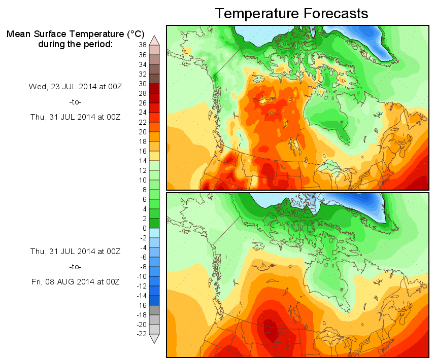
Interesting to note that temperatures of 25C (about 75F) are shown as GLARING RED on this map, even though temperatures of 75F for the Midwest are WELL below normal for the last 2 weeks of July.
Anyone surprised by the color scheme? (I didn’t think so).
My memory could be faulty, yet I seem to remember that the meteorologists used to use yellow for 70-70, orange for 80-89, red for 90-99, brown-red for 100-109 and white for 110 plus.
The color scheme “inflation” has been altered by about 13-15 deg F (7-8 deg C) to make current temperatures “look” alarmingly hot.
The flora and fauna have not been fooled. Jury is out on the “low-information-voters” / sheeple…….
make that 70-79….. I’m still agitating for a 5 minute edit window!!!
25C = 77F
18 + 18 = 36
36 + 9 = 45
45 + 32 = 77 QED 🙂
Down here in the Sunny South, where Summer = HHH, we’ve not really had much in the way of HHH. ‘Normally’, mid-latitude systems don’t get this far south after a week or two into June, thus the HHH. This year, we’ve gotten mid-latitude storms throughout the summer months, even into mid-July. The few years we do get them, they’re ‘back-door’ types (going East to West on the west side of strong high pressure regions). No back-door systems so far, and if we get to our ‘Autumnal Blast’ in three to four weeks, this year will be ‘a year without a normal summer’ for us. To get to normal Southern Summer weather, you have to go 5 degrees further south (Orlando, FL latitude) and even they’ve had cold fronts get to them when they are not typical this time of year.
Hmm, I just remembered. This is tropical cyclone season for us. Back in the dark ages, I remember being taught that the threshold sea surface temperature needed to initiate and maintain a tropical cyclone was, ta da, 25C/77F. Of course, SST isn’t sufficient. There are other threshold conditions required, to wit, an already existing area of low pressure at the low/mid altitudes, high pressure in the upper altitudes so you have little/no vertical wind sheer, and sufficiently warm to depth water temperatures. Skin SSTs of 25C or more won’t do. You need 25C/77F water temps to roughly 300ft/100m depth to have enough energy for the self-organized system of thunderstorms to sustain itself.
They claim June was the hottest month ever yet it’s so cold in the USA and other nations…
The Alarmists would have us believe that warm air ONLY flows over the ocean… That’s how they justify this claim… Yet nobody has presented evidence of warmer air or water in the oceans… And somehow the Sun discriminates against the land…
What a joke… All over the Huff Po and Think Progress… Day after day they cherry pick and make baseless claims, baseless ties to Global Warming.
CO2 mixed with the Satanic Polar Stirrer has made the all new CAGW’s Total Reality Vortex where real modeled climate exists.
That’s right… How is this Polar Vortex any different than Canadian cold fronts of the past?
It’s not…
How did Global Warming suddenly become Climate Change?? Same total garbage BS..
Taken literally, Climate Change theory would seem to require that CO2 causes the climate to be different. Any difference will do, apparently. “Different from what?” needs asking.
“Polar Vortex”, indeed! What happened to “Alberta Clippers”, “Cold air from Canada” and “Siberian Express”, etc. There will always be climate change and CO2 has nothing to do with it. Be not afraid of CO2 from burning fossil fuel. Be afraid, be very afraid of acid rain and environmental damage due to massive oil spills and coal mining.
This is becoming serious stuff people!
Geologically speaking, Global warming trends set in gradually allowing some time to adapt and tend to be rather beneficial. But the recent warming trend (Which is a roughly “25-30” year cycles) ended around 1997 !
Historically speaking, Cooling trends (Cold in this case!) tend to set in much more quickly and with our local Star (Sun) showing signs of dormancy not seen before this cooling/cold trend is “Extremely” serious and by this time next year (July, 2015) we will have an early indication of just how bad it will be !!
Early signs for this year are indicating an extremely brutal Winter (2014-2015) ahead, possibly something not yet seen in modern times !
Add to that cold Winter air the first “real” El Nino in 17 years (1997-1998) and we could see historical snow falls and accumulations grinding the Country to a halt. The Midwest and East-North East (Especially Chicago, Buffalo, etc…) could be devastated and New York City up through Boston will suffer equally and if that ice doesn’t completely melt the following Summer (2015) than very troubling times ly ahead !!!
And from that there will be no more worrying about the melting of the Arctic Ice sheet but rather the melting of the “Sub-Arctic” ice that seems to be on a Southward journey and who knows where/ when it will end ?
SERIOUS STUFF…