
If you pour water into one end of a swimming pool, it raises the water across the entire pool. Water always seeks a level surface.

The same thing is true with the oceans. If glacial melt was accelerating, then we see acceleration in sea level rise rates at every tide gauge on the planet. All of the oceans are interconnected.
If glacial melt was accelerating, we would see an upwards curvature in tide gauge data, like this.
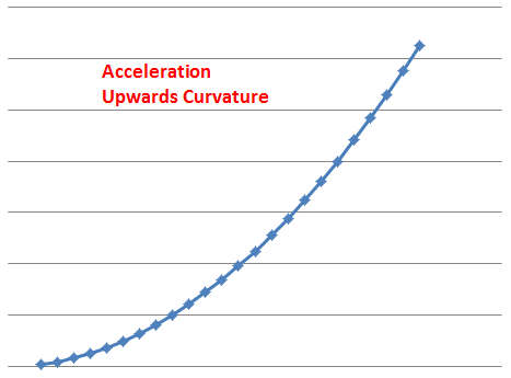
But we don’t. Tide gauges show no acceleration.

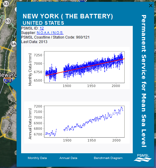
Tide gauges on the East Coast show no upwards curvature (acceleration)
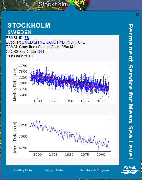
Tide gauges in Northern Europe show no acceleration. Sea level is falling there
Tide gauges on the west coast show no change in sea level at all

People who claim that glacial melt is accelerating, are lying. If it was happening, upwards curvature would be visible at every tide gauge on the planet. We don’t see that.

Lakes should rise too, more free water
Rivers will flow upstream
Morgan Wright says: “Rivers will flow upstream”
Snicker
Good one
Rivers do flow upstream where they joing the ocean and there are major tides.
Not estuaries. Rivers.
River acidification from CO2 will cause ASE, which causes CO2 bubbles to form in the water and the density of the water goes down so rivers will flow upstream. ASE is the anthropogenic seltzer effect.
No they wouldn’t. The surface area of the oceans wouldn’t change considerably.
AND if you analyse the satellite data since 1992 you will find that the rate of sea level rise has decreased ever so slightly over the last 22 years.
Works out to a negative acceleration of minus -0.05 mm/yr²
Though I appreciate the information, I just don’t buy that satellite or even the older tide gauge measurements are accurate enough to measure a change of 100ths of a mm. Now I understand your talking a trend over a period of 22 years in in your post and that of course is a horse of a different color and would indicate a drop of 1.1 mm during that period and that is certainly worth paying attention to. Just saying that when ever anyone starts talking of al change in even a few 10ths of mm in a year as being a significant indicator, I disregard it.
Thanks for the comment. Colorado is the keeper of satellite data and the story is really a bit more than just a drop from 3.5 mm/yr to 2.9 mm/yr read on:
If you go to the Internet Archive’s WayBack Machine:
http://archive.org/web/web.php
and plug in the URL for Colorado Universty’s Sea Level Research Group
http://sealevel.colorado.edu/
You will find records that go back to 2004. The earliest functional “mean sea level time series” link is from March 27th of that year, and if you follow that link through to “Inverted Barometer Applied” and “Seasonal Signals Removed” and click on text
http://web.archive.org/web/20040413231515/http://sealevel.colorado.edu/2004_rel1.2/sl_ib_ns_cu2004_rel1.2_global.txt
you will find the data as it existed for 1992.928 thru 2003.842 It’s then rather simple to download the series into Excel and find the slope. It comes out to be 2.6 mm/yr
If you then go to Colorado University’s Sea Level Research Unit today and dowload the “Raw data (ASCII)”
http://sealevel.colorado.edu/files/2015_rel1/sl_ns_global.txt
You will find that the same series for 1992.96 through 2003.846 comes out to be 3.5 mm/yr. Somehow over the last ten years the data has been changed. What had been 2.6 mm/yr in 2003 is now 3.5 mm/yr. An increase of 0.9 mm/yr.
Looks like this:
http://oi59.tinypic.com/24e8482.jpg
If you ask Colorado University about these changes they say:
–
“The sea level time series release from 2004 is over eight years old, and in that time many parts of the TOPEX and Jason-1 processing have been updated to reflect instrument and ancillary data improvements. Without recreating each processing change over the last eight years, We cannot point to any specific update that is the main cause of the differences between the 2004 and the current release. But a partial list of the more influential updates include:
– updated orbits
– updated radiometer corrections
– updated tide models
– updated sea state bias models
– updated dynamic atmosphere
“A review of the release notes shows how we continually apply what the altimeter science community considers to be the most up-to-date set of processing parameters.”
Tony,
yet another (simple) example of why this AGW-fraud is (bad) joke. Most people on the planet will understand that swimming pool story. It saddens me quite a bit to see that California – a hotspot of AGW-supporters – is not suffering at all…
Keep up the great work!
before the men in black from government polluted science they knew the reasons for sea level rise.
“Local effects make the tide gauge data difficult to interpret
It is important to remember that tide gauges are primarily a navigation aid. As such, many of these tide gauges are located near ports and other growing population centers. In turn, it is possible that these sites are subject to local land subsidence caused by ground water extraction;
For the last century, the global level of the sea appears to have risen at an average rate of nearly two mm/yr. However, in any given region, the apparent rate of rise can vary considerably from the long term global value. Geographical and temporal variations from the long-term mean value occur from a variety of causes such as interdecadal fluctuations of ocean density and circulation, continuing isostatic adjustment of the land level from the last deglaciation, subsidence due to the extraction of underground fluids, and others”
The interval 1930-1990 is long enough at 60 years to establish that the middle Atlantic region has a systematically higher rate of sea level rise than the long term global average of nearly 2 mm per year. The approximately 1.5 mm/yr extra rise for the region comes from a general sinking of the area into the ocean. Postglacial rebound, that is, readjustment (sinking in this area) of land elevations since the retreat of the glaciers at the end of the last ice age, is the cause.
Examining the Table more closely, we see that several sites (Portsmouth, Solomons Island) still do show substantial positive values of sea level rise for the last 20 years. It is possible that these sites are subject to land subsidence beyond the regional value caused by postglacial rebound. A typical cause of such localized subsidence is groundwater extraction, which in fact has occurred in both areas at an ever increasing rate in recent decades”
and on and on……
http://www.ngs.noaa.gov/GRD/GPS/Projects/CB/SEALEVEL/sealevel.html
Here in Stockholm the sea level is not falling rather the land is raising. Reasoning behind it is said to be the isages that pulled “down” the land and after melting the ice the land is still recovering (rizing with som mm/year). It´s seen both at sea and oround lakes etc.
Tony, totally off subject, but seeing your tweet about Saint Patrick’s day, I’ve written an article almost just for you on Saint Patrick outlining the clear evidence linking his birth to Old Kilpatrick near Glasgow Scotland. However, the reason I think you will particularly like it, is because we see almost the same kinds of “consensus” thinking in history as we see in Science.
The clear evidence in the old texts stating his birth was near Glasgow, was rejected. Why? It appears like Global Warming that is was blatant political manipulation. And scholars both ancient & modern appear happy to go along with this. This system is clearly corrupt!
Confirmation St. Patrick was born near Glasgow
Interesting.
We do know for sure that Sir Alex was born near Glasgow. Because I can’t understand anything he says.
I love it when they subtitle Scots or northerners for US television.
Did you understand anything at all in the song “Up and run awa”. It was written to commemorate the defeat of government forces by a smaller and less well equipped Jacobite force who just outsmarted them. Whenever I see Al Gore’s name I start singing it!
WEE, sleekit, cow’rin, tim’rous beastie,
O, what a panic’s in thy breastie!
Thou need na start awa sae hasty,
Wi’ bickering brattle!
I wad be laith to rin an’ chase thee,
Wi’ murd’ring pattle!
I’m truly sorry man’s dominion,
Has broken nature’s social union,
An’ justifies that ill opinion,
Which makes thee startle
At me, thy poor, earth-born companion,
An’ fellow-mortal!
That’s really good!
“WEE, sleekit, cow’rin, tim’rous beastie,
O, what a panic’s in thy breastie!”
Fits Al Gore and alarmist exactly
I was celebrating Robbie Burns night at a pub in Cambridge February 2003, the night the “thing of the past” returned to southern England.
The M11 turned into a giant parking lot because the govt had quit buying grit on advice of the Met Ofiice.
At the time of St.Patrick the Water around Scotland was around 2-3m higher. You can tell this because the Roman Antonine Wall cannot be found on the present flat raised ground next to the Forth. In other words, the wall must have finished where it came down the hill and the flat ground was underwater in the Roman period. No one disputes this, nor do they dispute that the south of Briton has been sinking since the Roman period (more than Scotland is rising!). So, it is well known that sea level has been changing and the many raised beeches in Scotland are clear testimony to this fact.
So, only the daft or the fraudulent would look at a graph showing steady change in sea level and say anything other than it is changing as it has been changing very slowly since the last ice-age.
The sea level rise is another example of the ClimAstrologist counting how many devils are dancing on their pens. Actually the level has fallen about a meter and a half.
TEN STUDIES PROVING SEA LEVEL HAS NOT RISEN AFTER HOLOCENE OPTIMUM
The graph Wiki shows is misleading since it is in increments of 20 meters. Another problem is the sea level data is not raw data but adjusted data.
http://upload.wikimedia.org/wikipedia/commons/1/1d/Post-Glacial_Sea_Level.png
If you look closely the following graph actually shows the meter to two meter decline in sea level, if you discard the one Santa Catarina outlier.
http://upload.wikimedia.org/wikipedia/commons/1/1e/Holocene_Sea_Level.png
The Link for the ten studies:
https://stevengoddard.wordpress.com/2015/03/08/the-cant-find-the-missing-water-and-it-is-a-travesty-that-they-cant/#comment-499786
Stockholm’s probably a classic case of glacial isostatic rebound. http://cs.mcgill.ca/~rwest/wikispeedia/wpcd/wp/p/Post-glacial_rebound.htm
“In Sweden, Lake Mälaren was formerly an arm of the Baltic Sea, but uplift eventually cut it off and led to it becoming a freshwater lake in about the 12th century, at the time then Stockholm was founded at its outlet. Marine seashells found in Lake Ontario sediments imply a similar event in prehistoric times. In several Nordic ports, like Tornio, the harbour had to be relocated several times in the past centuries.”
The point is that the second derivative is zero.
http://www.panoramio.com/photo/40688562
When the 10 year rolling trend is calculated for the New York data, there is a fairly regular pattern of peaks and troughs every 15 years or so. So the trend is not as constant as it first appears.
The rolling 10 year trend is currently about 8mm/year, but as recently as 2011 it was 15mm/year and in 2005 it was -5mm/yr. It was also 15mm/year in the 1880’s.
The 30 year rolling trend also shows a cyclical pattern. It is currently about 4.7mm/year but in the 1980’s it was around 1.7mm/year. It was also around the present level in the 1950’s and the 1890’s.
Does anyone know the cause of this apparent speeding up, and slowing down, of sea level rise on an apparently regular basis? Is it astronomical?
Don ‘t know the cause, but it’s handy to point out that the 30 year rate was higher in the year ending in 1953 than the 30 rate ending in 2013.
I guess that means you have replicated my figures?
My original ones were using monthly data and when I did them again with annual data the trends were slightly different but the basic premise hold true.
Thanks for that Tony.
I will be forwarding this to the Canadian Minister if the Environment, along with a request that she pass the info along to her department heads.
I have no back ground in hydrology nor geology so may be someone could answer me two questions.
1. The visible land is growing by about 27 cubic kilometers a year, and given that the oceans make up 75% of the earth, wouldn’t it be safe to say the the earth is adding 81 cubic kilometers of land that we can not see, Would this not account for a slight rise in sea level, (I mean they are talking about a 1 mm rise in sea level a year)?
2. Those who go by the tidal gauges do not take into account the variations in water that is in transition, through evaporation, locked in snow, rivers and dams. They would have to assume that non ocean water is constant all over the earth and balances it self out, which is untrue.
I don’t believe that any super computer can handle all the variables that go into the make up of our planet.
“(I mean they are talking about a 1 mm rise in sea level a year)?”
The key word in the OP is “acceleration”. Sea level rise is not accelerating, about which propagandists and their moonbat religious followers have been perpetually saying.
Actually the key is the ERROR BARS.
1 mm rise a year? 1mm is the thickness of fingernail
Give me a break.
Shorelines change. The oceans erode, rivers infill, deltas change. You get tectonic uplifting and subsiding. Buildup by people filling in salt water marsh areas. Buildings on those areas causing subsiding as the fill compresses.
And then there are tides and not just daily tides.
https://chiefio.wordpress.com/2014/02/16/tides-vectors-scalars-arctic-flushing-and-resonance/
https://chiefio.wordpress.com/2014/02/04/which-way-what-water-wanders/
Again we are getting into precision that does not actually exist just like with the temperature numbers.
Disillusioned: “The key word in the OP is “acceleration”.
Reply
Gail Combs says:
“Actually the key is the ERROR BARS.”
I didn’t see “ERROR BARS” in the OP.
OT – I wonder if it was a tribute to the kiddie pool when they called it ‘El Nino’?
Nice thought, but no. The effects of El Ninos were first noticed around Peru, where that lack of cold nutrient rich upwelling sea water reduced fishing catches. Sailors named it El nino since it usually peaked around Christmas.
http://www.cgd.ucar.edu/cas/papers/clivar97/en.dfn.html
Actually no, it’s not a nice thought, and actually was a joke.
You are not a nice gator!
https://c1.staticflickr.com/9/8381/8523488186_0793cb18c5_z.jpg
That’s a nice gator …
https://muchmoremuchier.files.wordpress.com/2012/03/gator.jpg
Gator likes having his tail rubbed by pretty girls. Not so crazy about hand waving guys.
Niño
If you take a leak at one end of the pool, its sends all the people to the other end of the pool and they are raised up and step out. Normally with a lot of yelling.
Glad to see this information concisely presented. The environmental extremists are raving about the glacial melt continuously – good to see the actual facts.
I have only one suggestion relative to your statement:
“If glacial melt was accelerating, we would see an upwards curvature in tide gauge data, like this.”
Since the upwards curvature is nonexistent, it should read:
“If glacial melt were accelerating, we would see an upwards curvature in tide gauge data, like this.”
Alas, the subjunctive case is too often ignored in the English language.
Tide gauges have to contend with tectonic movements, and well, tides. One would think that the satellite data would be superior and show the results of all the “melting” but it seems to be under the control of the borg and suffers from the same upjusting bias that the temperature record endures.
But that aside all the news items that quote “experts” who say a meter of sea level rise by 2100 are just plain nuts.
Right on!
I agree with your swimming pool analogy. However, ignorant question here: You showed sea levels going up and down around the world. Why aren’t they all going up or down (linearly)? Sorry if the was answered before….
There is also the wind. Specifically the trade winds and they are NOT constant.
https://bobtisdale.files.wordpress.com/2014/02/figure-52.png
FROM: https://bobtisdale.wordpress.com/2014/02/22/el-nino-and-la-nina-basics-introduction-to-the-pacific-trade-winds/
“trade winds ‘affect’… (verb)
The “effects” of trade winds (noun)
Again, just trying to help and clarify. Words do have specific meanings, as I’m sure you’re aware. I’ve found that, for me, errors in syntax, grammar, spelling, punctuation, etc. detract from meaning and distract me from the thread of the communication. They stop my train of thought dead in its (not “it’s”) track.
Thanks Donna,
John Dewey and the Progressives used my school for ‘experiments’ I never learned phonetics or grammar.
Gail,
Given the circumstances, I think you do quite well.
Hey Donna! My mother gave me a copy of this book because she knows how I feel about the abuse and misuse of one of the world’s greatest and most descriptive languages (best in my opinion). You have probably read it, but if not, do yourself a favor, and enjoy!
http://upload.wikimedia.org/wikipedia/en/0/0b/ES%26L.png
http://www.amazon.com/Eats-Shoots-Leaves-Tolerance-Punctuation/dp/1592402038
Gator,
Although I haven’t yet read this one, I’ve had lunch with Michael Strumpf, author of The Grammar Bible, a couple of times. Even so, I could benefit from reviewing the rules again.
I merely wish there were a way to re-educate people without offending them.
Gator,
Are you a Gulcher? Did you know that a mini-series is in the works?
I am familiar with the name but admittedly not the work, so do keep me informed.
One of my all time favorite documentary series ever was Melvyn Bragg’s “The Adventure of English”. If memory serves it ran on the History Channel. It was utterly fantastic. I burned three copies, one for me, one for my father, and an extra. I also found a commercial DVD after much searching, but it was in a different format from US DVD’s,, and I went as far as to buy a universal DVD player so I could watch and share a better copy. If you have not seen this series, you must!
http://www.amazon.com/dp/B001O7R75E/?tag=googhydr-20&hvadid=44758559917&hvpos=1t1&hvexid=&hvnetw=g&hvrand=4221930145015272797&hvpone=&hvptwo=&hvqmt=b&hvdev=c&ref=pd_sl_3d9usm6xup_b
A 1,500 year journey with Melvyn Bragg and a team of experts uncovers the fascinating tale of a remarkable language. While they share the secrets of how English has evolved and impacted society in this 8-part documentary, the rain in Spain stays mainly on the plain.” Includes 8 episodes on 4 DVDs. 2002-03/color/6 hrs., 48 min/NR/widescreen.
I watched it three times, and got more out of it with each viewing.
So “it raises the water across the entire pool. Water always seeks a level surface.” And Tide gauges on the East Coast show no upwards curvature (acceleration).” But “Tide gauges in Northern Europe show no acceleration. Sea level is falling there.” And then “Tide gauges on the west coast show no change in sea level at all.” And then “All of the oceans are interconnected.”
So tell me again how your swimming pool works?
http://thewatchers.adorraeli.com/wp-content/uploads/2011/03/nutshell.gif
http://thewatchers.adorraeli.com/data/uploads/2011/03/Earthscrust.gif
“The same thing is true with the oceans.”
No, it is certainly not.