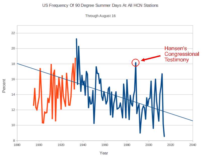
The frequency of 90 degree days in the US has been plummeting for 80 years, and is the lowest on record this summer
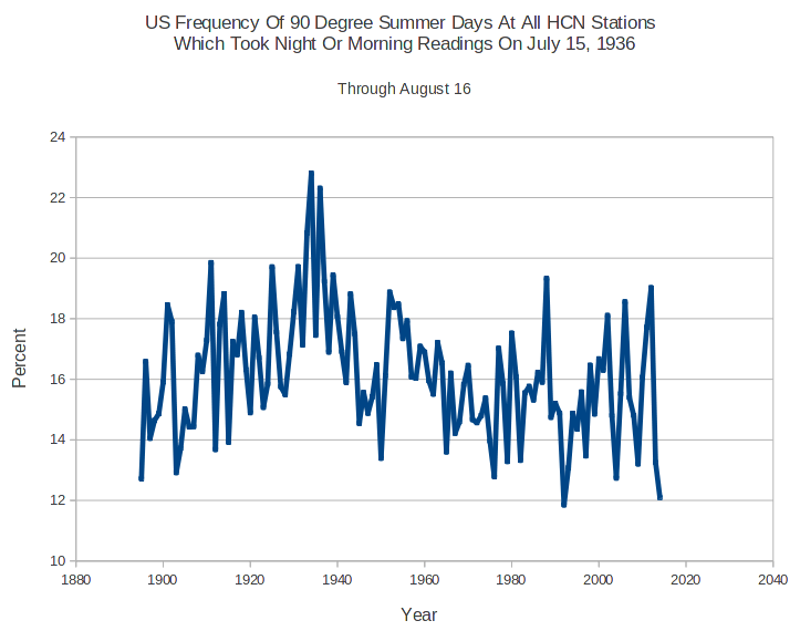
Alarmists will try to complain that this trend is due to time of observation bias, but that argument is a non-starter. The graph below shows the identical pattern for stations which took morning or night readings on July 15, 1936.
Conclusion : The US is getting much cooler, and Time of Observation Bias adjustments are incorrect. Below is the list of morning stations from July 15, 1936
FAIRHOPE 2 NE       	AL
AJO                 	AZ
CHILDS              	AZ
FT VALLEY           	AZ
GRAND CANYON NP 2   	AZ
LEES FERRY          	AZ
MIAMI               	AZ
PARKER              	AZ
PRESCOTT            	AZ
ROOSEVELT 1 WNW     	AZ
SACATON             	AZ
SAFFORD AGRICULTRL C	AZ
SAINT JOHNS         	AZ
TUCSON WFO          	AZ
WICKENBURG          	AZ
WILLIAMS            	AZ
YUMA CITRUS STN     	AZ
GRAVETTE            	AR
BERKELEY            	CA
BLYTHE              	CA
CEDARVILLE          	CA
CHULA VISTA         	CA
CUYAMACA            	CA
DAVIS 2 WSW EXP FARM	CA
FAIRMONT            	CA
FARMVILLE 2 N       	VA
HANFORD 1 S         	CA
HEALDSBURG          	CA
INDEPENDENCE        	CA
LODI                	CA
MERCED              	CA
NEWPORT BEACH HARBOR	CA
ORLAND              	CA
ORLEANS             	CA
PASO ROBLES         	CA
QUINCY              	CA
SAN LUIS OBISPO POLY	CA
SUSANVILLE 2SW      	CA
TAHOE CITY          	CA
TEJON RANCHO        	CA
TUSTIN IRVINE RCH   	CA
WILLOWS 6 W         	CA
YREKA               	CA
FT COLLINS          	CO
FT MORGAN           	CO
TRINIDAD            	CO
MILFORD 2 SE        	DE
APALACHICOLA  AIRPOR	FL
BARTOW              	FL
BELLE GLADE         	FL
FT LAUDERDALE       	FL
FT PIERCE           	FL
LAKE CITY 2 E       	FL
OCALA               	FL
PERRINE 4W          	FL
TARPON SPGS SEWAGE P	FL
BAINBRIDGE INTL PAPE	GA
EASTMAN 1 W         	GA
GLENNVILLE 3NW      	GA
HAWKINSVILLE        	GA
MILLEDGEVILLE       	GA
NEWNAN 5N           	GA
QUITMAN 2 NW        	GA
TIFTON              	GA
WEST POINT          	GA
ARROWROCK DAM       	ID
CAMBRIDGE           	ID
DWORSHAK FISH HATCH 	ID
FENN RS             	ID
HOLLISTER           	ID
KELLOGG             	ID
OAKLEY              	ID
PAYETTE             	ID
SALMON-KSRA         	ID
MCLEANSBORO         	IL
WALNUT              	IL
DELPHI 2 N          	IN
PAOLI               	IN
SALEM               	IN
SHOALS 8 S          	IN
CHARLES CITY        	IA
FOREST CITY 2 NNE   	IA
COLUMBUS            	KS
INDEPENDENCE        	KS
SAINT FRANCIS       	KS
WAKEENEY            	KS
FRANKFORT DOWNTOWN  	KY
ALEXANDRIA          	LA
BASTROP             	LA
PLAIN DEALING 4 W   	LA
EASTPORT            	ME
LEWISTON            	ME
WOODLAND            	ME
CUMBERLAND 2        	MD
MILLINGTON 1 SE     	MD
PRINCESS ANNE       	MD
AMHERST             	MA
BEDFORD             	MA
GREAT BARRINGTON 2N 	MA
LAWRENCE            	MA
PLYMOUTH-KINGSTON   	MA
ALLEGAN 5NE         	MI
FAYETTE 4 SW        	MI
MIDLAND             	MI
CHASKA              	MN
DETROIT LAKES 1 NNE 	MN
MORRIS WC EXP STN   	MN
NEW ULM 2 SE        	MN
PIPESTONE           	MN
CANTON 4N           	MS
GREENVILLE          	MS
KOSCIUSKO           	MS
NATCHEZ             	MS
PONTOTOC EXP STN    	MS
STATE UNIV          	MS
APPLETON CITY       	MO
CLINTON             	MO
FARMINGTON          	MO
JEFFERSON CITY WTP  	MO
LAMAR 2W            	MO
LEBANON 2W          	MO
LEES SUMMIT REED WR 	MO
LEXINGTON 3E        	MO
MEXICO              	MO
MOBERLY             	MO
MTN GROVE 2 N       	MO
SPICKARD 7 W        	MO
UNIONVILLE          	MO
ANACONDA            	MT
CHINOOK             	MT
FORKS 4 NNE         	MT
FT ASSINNIBOINE     	MT
FORTINE 1 N         	MT
HUNTLEY EXP STN     	MT
KALISPELL GLACIER AP	MT
MOCCASIN EXP STN    	MT
PLEVNA              	MT
ALLIANCE 1WNW       	NE
ATKINSON 3SW        	NE
BEATRICE 1N         	NE
BROKEN BOW 2 W      	NE
CRETE               	NE
FAIRBURY 5S         	NE
FAIRMONT            	NE
FRANKLIN            	NE
IMPERIAL            	NE
LODGEPOLE           	NE
NORTH LOUP          	NE
OAKDALE             	NE
PURDUM              	NE
WEEPING WATER       	NE
AUSTIN #2           	NV
FALLON EXP STN      	NV
MCGILL              	NV
MINA                	NV
WELLS               	NV
BOONTON 1 SE        	NJ
INDIAN MILLS 2 W    	NJ
MOORESTOWN          	NJ
FT SUMNER           	NM
LAS VEGAS WWTP      	NM
MTN PARK            	NM
TUCUMCARI 4 NE      	NM
TULAROSA            	NM
BATAVIA             	NY
ELMIRA              	NY
GLENHAM             	NY
INDIAN LAKE 2SW     	NY
ITHACA CORNELL UNIV 	NY
LAKE PLACID 2 S     	NY
LOWVILLE            	NY
OSWEGO EAST         	NY
SETAUKET STRONG     	NY
STILLWATER RSVR     	NY
TROY L&D            	NY
TUPPER LAKE SUNMOUNT	NY
WALDEN 1 ESE        	NY
WALES               	NY
WEST POINT          	NY
YORKTOWN HEIGHTS 1W 	NY
ALBEMARLE           	NC
ELIZABETH CITY      	NC
KINSTON 7 SE        	NC
SMITHFIELD          	NC
TARBORO 1 S         	NC
WAYNESVILLE 1 E     	NC
BOTTINEAU           	ND
CROSBY              	ND
DICKINSON EXP STN   	ND
DUNN CENTER  1E     	ND
FT YATES 4 SW       	ND
FULLERTON 1 ESE     	ND
JAMESTOWN STATE HOSP	ND
LANGDON EXP FARM    	ND
LISBON              	ND
MANDAN EXP STN      	ND
NAPOLEON            	ND
NEW ENGLAND         	ND
RICHARDTON ABBEY    	ND
FINDLAY WPCC        	OH
HILLSBORO           	OH
BEND                	OR
BROOKINGS 2 SE      	OR
CONDON              	OR
FREMONT 5 NW        	OR
HEPPNER             	OR
MC MINNVILLE        	OR
PILOT ROCK 1 SE     	OR
ROSEBURG KQEN       	OR
TILLAMOOK           	OR
VALE                	OR
FRANKLIN            	PA
NEW CASTLE 1 N      	PA
PALMERTON           	PA
READING 4 NNW       	PA
RIDGWAY             	PA
STROUDSBURG         	PA
ANDERSON            	SC
CHERAW              	SC
COLUMBIA UNIV OF SC 	SC
CONWAY              	SC
DARLINGTON          	SC
GREENWOOD           	SC
KINGSTREE           	SC
ORANGEBURG 2        	SC
SUMMERVILLE 4W      	SC
YEMASSEE            	SC
DUPREE              	SD
FAULKTON 1 NW       	SD
FORESTBURG 4 NNE    	SD
GANN VALLEY 4NW     	SD
MILBANK 4 NW        	SD
OAHE DAM            	SD
RAPID CITY 4NW      	SD
COPPERHILL          	TN
CROSSVILLE ED & RESE	TN
DOVER 1 W           	TN
MURFREESBORO 5 N    	TN
NEWPORT 1 NW        	TN
UNION CITY          	TN
ALBANY              	TX
ALICE               	TX
ALPINE              	TX
BALLINGER 2 NW      	TX
BALMORHEA           	TX
BLANCO              	TX
BOYS RANCH          	TX
BRENHAM             	TX
BROWNWOOD 2ENE      	TX
CATARINA            	TX
CORSICANA           	TX
CROSBYTON           	TX
DANEVANG 1 W        	TX
DUBLIN 2SE          	TX
EAGLE PASS 3N       	TX
ENCINAL             	TX
FALFURRIAS          	TX
GREENVILLE KGVL RADI	TX
HASKELL             	TX
LAMPASAS            	TX
LLANO               	TX
LULING              	TX
MCCAMEY             	TX
MEXIA               	TX
MIAMI               	TX
MULESHOE #1         	TX
NEW BRAUNFELS       	TX
PECOS               	TX
QUANAH 2 SW         	TX
RIO GRANDE CITY     	TX
SNYDER              	TX
TEMPLE              	TX
WEATHERFORD         	TX
ALTON               	UT
DESERET             	UT
ESCALANTE           	UT
FILLMORE            	UT
FT DUCHESNE         	UT
HEBER               	UT
LEVAN               	UT
LOGAN UTAH ST UNIV  	UT
PANGUITCH           	UT
ST GEORGE           	UT
SCIPIO              	UT
UTAH LAKE LEHI      	UT
BREMO BLUFF         	VA
CHARLOTTESVILLE 2W  	VA
DALE ENTERPRISE     	VA
PENNINGTON GAP      	VA
PIEDMONT RSCH STN   	VA
ROCKY MT            	VA
STAUNTON WATER TRMTM	VA
WILLIAMSBURG 2 N    	VA
BLAINE              	WA
CEDAR LAKE          	WA
LONG BEACH EXP STN  	WA
ODESSA              	WA
POMEROY             	WA
PORT ANGELES        	WA
PULLMAN 2 NW        	WA
RAYMOND 2 S         	WA
RITZVILLE 1 SSE     	WA
SUNNYSIDE           	WA
WATERVILLE          	WA
WENATCHEE           	WA
WILBUR              	WA
SPENCER             	WV
HANCOCK EXP FARM    	WI
MANITOWOC           	WI
ALTA 1 NNW          	WY
COLONY              	WY
GREEN RIVER         	WY
MIDWEST             	WY
NEWCASTLE           	WY
SARATOGA            	WY
SHERIDAN FLD STA    	WY
WORLAND             	WY
YELLOWSTONE PK MAMMO	WY


Tony,
A lot of people may not have known (me being one of them) that some stations were read (only?) in the morning and some (only?) in the afternoon. I believe your premise is probably correct, but I don’t fully understand it. Is the graph (just above the conclusion statement) a composite of morning and afternoon readings? And the first graph is afternoon only? Some background on the theory of TOBs and how they claim to adjust for it would be helpful.
Here: http://www.ncdc.noaa.gov/oa/climate/research/ushcn/ushcn.html
I see this:
“The TOB introduces a non climatic bias into the monthly means. The TOB software is an empirical model used to estimate the time of observation biases associated with different observation schedules and the routine computes the TOB with respect to daily readings taken at midnight. Details on the procedure are given in, “A Model to Estimate the Time of Observation Bias Associated with Monthly Mean Maximum, Minimum, and Mean Temperatures.” by Karl, Williams, et al.1986, Journal of Climate and Applied Meteorology 15: 145-160.”
Daily readings taken at midnight?????
Okay, I can go look for that document, but understanding this issue requires understanding what equipment was used, how it was designed to be used, and how it was (ostensibly) misused.
Perhaps there have been extensive discussions on this, and I’ve just missed them.
If a min/max thermometer is reset only once a day in the morning, it tends to double count cold temperatures, leading to a cold bias. Opposite if it is reset once a day in the afternoon.
Any sane,honest operator with half a brain will reset the maximum in the morning, and reset the minimum in the afternoon – which is most likely what was really going on.
COLUMBIA UNIV OF SC SC
No. There was no USC station in 1936. The first USC station was established in 1954. It was moved to the Bates House location in 1973.
http://www.erh.noaa.gov/cae/columbiahistory.pdf
1880s
http://cdiac.ornl.gov/cgi-bin/broker?id=381944&_PROGRAM=prog.gplot_meanclim_mon_yr2013.sas&_SERVICE=default¶m=TMIN&minyear=1872&maxyear=2013
Your linked graph shows temperatures. It doesn’t show the locations of the measurements.
Here’s another link:
http://wattsupwiththat.com/2009/02/07/how-not-to-measure-temperature-part-81-roofing-the-past-in-columbia/
. . . showing that the station moved around.
It’s not very warm here in the UK at the moment and it looks set to get much colder this week 🙁
“Summer Frost Predicted as Met Office Issues Severe Weather Warning”
uk.news.yahoo.com/summer-frost-predicted-met-office-issues-severe-weather-165711936.html#QeuhwFC
Some place in Northern Wisconsin here already had a mid August frost pretty close to the line of 45 deg. Latitude.
Yup everything is OK looking forward to the Ice Age all is NORMAL this August. No Climate change repeat NO CLIMATE CHANGE
Everyone can CHILL now.News Flash the EPA no longer needed! Bring back DDT in human Breast Milt too!
Peace…….
Just saw this on Drudge. It fits in nicely with “US having coldest summer”.
http://www.dailymail.co.uk/news/article-2727734/Wet-cold-bank-holiday-way-forecasters-warn-two-weeks-bad-weather-ahead.html
The lows are getting less low and the highs are getting less high. The Climate is moderating. Oh, noes! Wotevah will we do?