
The press got hysterical four years ago when an iceberg calved off the Petermann Glacier in Greenland
Since then, nothing has changed. This is how the glacier looked last week.
Glaciers flow to the sea and calve. That is what they do. That is what they have to do. It has nothing to do with warming or climate change. They are a river of ice. Rivers flow to the sea. Only a complete moron or a climate alarmist would see this as a problem.
But I repeat myself.

Whats not commonly understood is that snowfall inland adds pressure to the Ice River and makes it flow faster. But the snow/ice that contributed to that pressure, represents moisture removed from the ocean, remaining on land, and thus contributing to a reduction in sea-level. And it is spread over a far more vast surface than the glacier itself.
Why have I not seen anything in the media about the glacier growing?
Didn’t the Hildebeast fly to Greenland & fix the problem?
That was a ‘reset’ with Russia (I think).
Seems it did change – it grew back.
The Hildebeast kissed the glacier like she use to kiss Web Hubble’s Daughter’s boo-boos and everything was well…. I mean not so bad.
You could make a good case that the glacier extent has increased. Probably rotten four year old ice though.
More like rotten, decayed, arthritic, 100 year old ice, but whose counting?
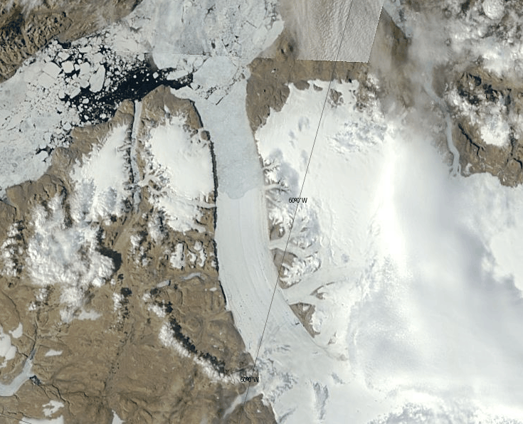
I saved this satellite pic a few days ago for posterity.
The glacier has moved 3-5 kms since it last calved in 2012. Satellite pic through Worldview which consolidates the Modis satellite pictures in a much more useful form. The operators of Worldview inserted the grey line in this pic which is where the glacial front was in 2012.
http://s16.postimg.org/i5j9glgvp/Petermann_July14_14.jpg
https://earthdata.nasa.gov/labs/worldview/
.
On the top right there is button to move to the polar view. You can move around dates (at the bottom) and maintain the same position, lots of features.
Where did the widespread idea that glaciers are ‘static’ or extremely slow, ponderous things that are never changing come from?
In geology and related firleds it’s pretty much been known, for a long time, that glaciers are dynamic and ever changing…and can do so quite rapidly.
When the seal level goes up there will be more sharks, which will bring the seal level down.
Did you ever think how much faster the sea would rising if it were not for all those sponges down on the bottom?
🙂
Sponges? just think of all the fish drinking it! 😆
Some ignorant Democrat congressman and his media stooges made a big deal about that glacier calving. He refered to the broken off portion as deniersberg or some such. Something tells me that skeptics won’t be getting any apologies from him.
His media stooges won’t be asking him for a follow-up regarding the present state of the glacier either.
They sound like a bunch of moraines to me.
.. and terminal. “Terminal moraines” … a geologist’s joke …
You guys need to stop Graben your Horst. It will make you go blind.
“Glacial puns,” he replied, icily.
If it appears to retreat, it’s news. If it remains stable or grows, nothing.
Here’s the 2013 SmithsonianRag.com piece citing the 16 July 2010 calving:
http://www.smithsonianmag.com/science-nature/greenlands-glaciers-are-hemorrhaging-ice-best-seen-by-photos-from-space-11332450/
No, no, no. If the glacier is growing that’s bad, too. it implies resistive stress on the glacier bed has been lubricated by global warming. The faster it grows toward the sea, the greater the CAGW.
https://openknowledge.worldbank.org/bitstream/handle/10986/7174/wps4136.txt?sequence=2
“Since the IPCC Third Assessment Report in 2001, there has been an increased effort to
improve measures of mass loss for the Greenland ice sheet and its contribution to SLR.
Using satellite interferometry observations, Ringot and Kanagaratnam (2006) detected
widespread glacier flow acceleration in the lower latitudes between 1996 and 2000”
http://content.lib.utah.edu/utils/getfile/collection/etd3/id/2197/filename/2198.pdf
Beware the glacial surge!
The image with the black line (first link by Bill Illis – thanks!) shows the glacier to the bottom and that will be sliding downhill – up in this photo. Several tributary glaciers are entering from the right side. My take is that the real sliding glacier ends just up from the black line as linear features common to glaciers can be seen to there. Up from that in the photo the ice appears to be frozen in place after the calved iceberg moved away from the front of the glacier. At the very top of the photo the ice surface seem to be that of glacier ice (bergs) that have become trapped against one another and within some frozen surface water.
No evidence here of a warming ocean, but perhaps, the opposite.
AGW causes GRAVITY … don’t you know this …!!!!!!!
or
+1
i believe some of the people here http://forum.arctic-sea-ice.net/index.php/topic,778.2400.html are not too kind in comments to tony. i know who i think the fruitloops are after reading the last 6 pages of the comments ,wackjob city.
I think you top picture is of the first major calving event (2010) and predates the second (2012).
Both those calving events were related to major structural cracks that already existed as far back as 2000 and which travelled down the glacier for a decade before the inevitable finally occurred. . . .
https://www.flickr.com/photos/126112946@N07/14736920315/
I’ve not been able to find imagery older than 2000. Maybe Landsat?
Looks like sea ice ahead of the 2012 calving point.
Not entirely all of it…
If you go to Bill’s link (I think that’s it) and make sure you have the coastlines added you can see that it’s advanced about 1 KM from that line (2012 point)…maybe more.
While I enjoy the heck out of most of your posts, in this case you are very wrong. There was growth of the glacier and another calving in 2012, and more growth since then. A lot of change. Currently it is just sea ice that gives the appearance of no change. Looking at the sat image with corrected reflectance 7-2-1 makes it easier to see the difference between the glacier ice and sea ice.
https://earthdata.nasa.gov/labs/worldview/?switch=arctic&products=baselayers,MODIS_Aqua_CorrectedReflectance_Bands721,!MODIS_Aqua_CorrectedReflectance_TrueColor,MODIS_Terra_CorrectedReflectance_TrueColor&time=2014-07-16&map=-446854.968704,-1052879.587482,-78214.968704,-863439.587482
Here is the 2012 event.
https://earthdata.nasa.gov/labs/worldview/?switch=arctic&products=baselayers,MODIS_Terra_CorrectedReflectance_TrueColor,MODIS_Aqua_CorrectedReflectance_TrueColor&time=2012-07-18&map=-1030214.968704,-573822.892194,-661574.968704,-384382.892194
Video of 2012 event.
https://www.youtube.com/watch?v=8bVnNkLLYIY