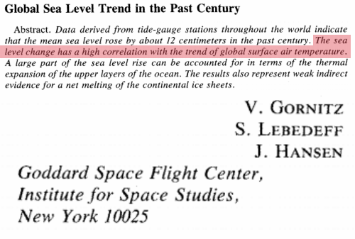
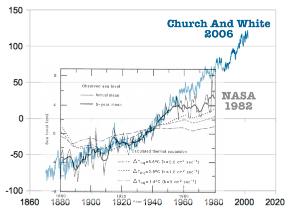
In 1982, NASA showed that sea level rise dropped off sharply after 1950.
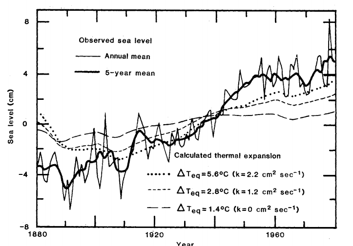
NASA said that there was a high correlation with global surface temperature (i.e. global warming occurred from 1880 to 1940 and slowed considerably after 1950.)
In 1990, the IPCC said there was no convincing evidence of an acceleration in sea level rise during the 20th century.
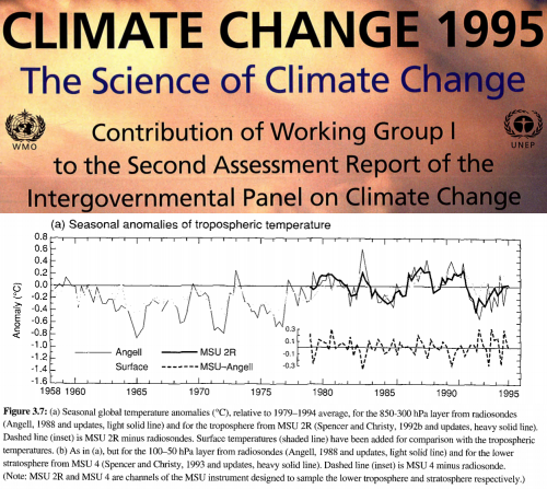
The 1995 IPCC report showed no warming from the 1950’s to the 1990’s.
The NASA/IPCC data wrecked two essential parts of the global warming scam – post-1950 warming and post-1950 sea level rise. So they found people who were willing to change the data to match the models. The current NASA sea level data is based on this confirmation bias fishing expedition.
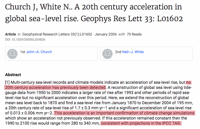
This acceleration is an important confirmation of climate change simulations
The overlay below shows how they changed the post-1950 data to match the theory.
Church and White discovered a mysterious break in sea level in the year 1926, when sea level rise rates suddenly increased by almost 250% to 1,94 mm/year.
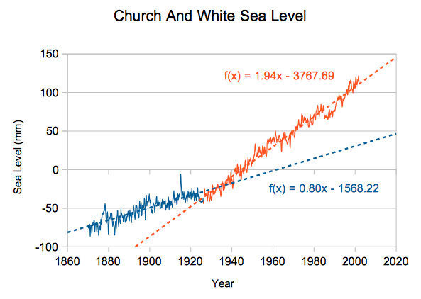
I can’t find one single tide gauge anywhere on the planet which shows this post-1926 acceleration. The Church and White study is utter nonsense.
But the NASA fraud gets worse. Their tide gauge data says 1.94 mm/year, but their web site shows 3.4 mm/year.
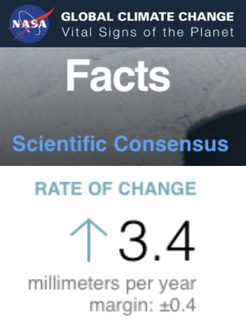
Climate Change: Vital Signs of the Planet: Sea Level
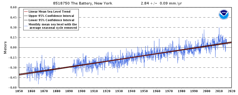
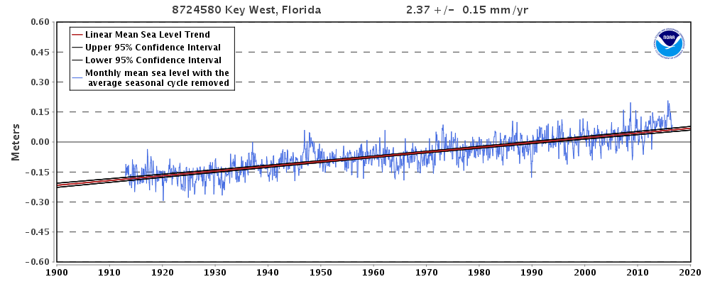
Only 10% of NOAA tide gauges show that much sea level rise, and all of those are in places where the land is rapidly sinking.
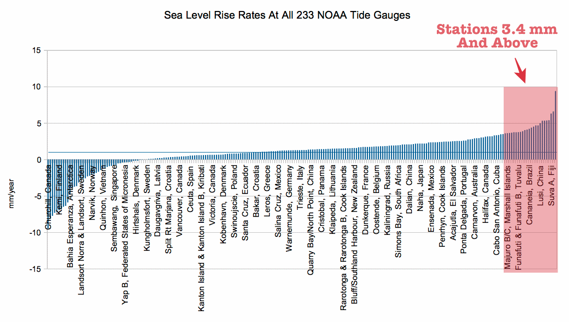
Sea Level Trends – MSL global stations trends table
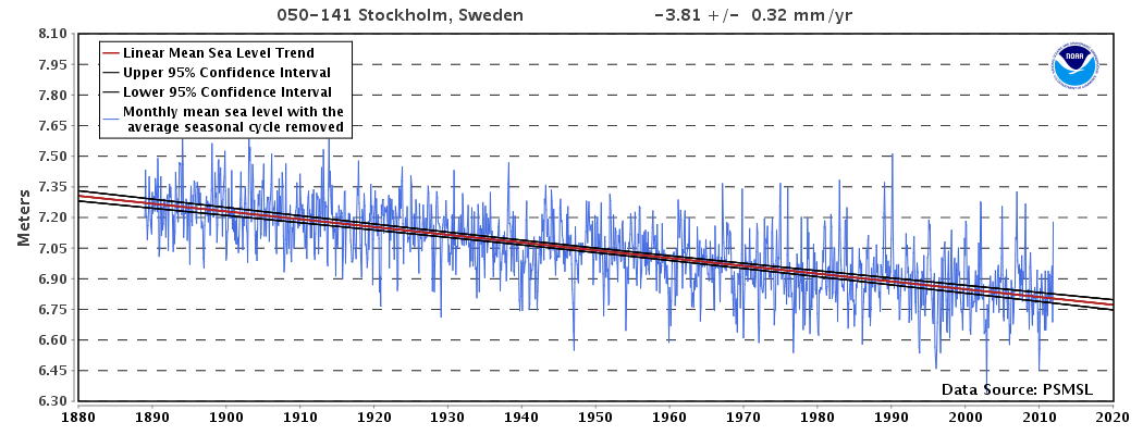
NOAA says sea level is rising half as fast as NASA’s claims.
absolute global sea level rise is believed to be 1.7-1.8 millimeters/year
NASA sea level claims are blatant fraud – being done right in front of our faces.
Church and White also cherry picked the tide gauges. There are over 12oo tide gauges in the Permanent Service for Mean Sea Level and Church and White threw out around 700 of them. If you examine the rate of sea level rise for the 500 they retained against the 700 they threw out it becomes readily apparent that they had a bias toward selecting those gauges that displayed a higher rate. Here’s what it looks like. The top line shows that after their bias only netted a modest 2.4 mm/yr they managed to jack it up to 3.2 mm/yr.
Steve Case, in the PSMSL database there are about 40 long record tide gauges with differential GPS land motion correction available within 10 km. Northern hemisphere bias of course but the best available. Renowned expert Nils-Axel Moerner calculated these show ~2.2mm/year and no acceleration. The number is important because it closes to the sum of thermosteric rise estimated from ARGO (0.6mm/yr) plus ice sheet mass loss estimated from GRACE after applying the YE 2013 diff GPS measured GIA correction to Antarctica (1.6mm/yr). All previous GRACE estimates for Antarctica ice loss were too high because of a faulty modelled GIA correction.
SC, I just checked C&W 2011. The 3.2mm/yr is from satellite altimetry, not tide gauges. Has to be wrong because does not close. The problems with sat alt were discussed together with a rather thorough debunking of two papers explaining a supposed slow down in SLR ‘detected’ by sat alt in essay PseudoPrecision in my ebook Blowing Smoke.
Tony,
VICE news organization is now doing daily reports on HBO. These guys are big warmists. Last night they featured Tangier Island as an example of climate change induced sea level rise causing climate change refugees. They briefly mentioned that the island is sinking on it’s own due to the soil composition, but greatly emphasized that sea level increase due to climate change was the main culprit. The report showed impressive video of streets covered in water and claimed that the island would be uninhabitable in 25 years. The 500 inhabitants want a $30 million sea wall to save the island.
If you get a chance, take a look at it online. These guys have no shame.
They did a story including me once – as an evil, secretive conspirator against the climate. They made no attempt to contact me or verify any of their lies.
You should write a piece on the real numbers for Tangiers Island. At only 4 feet above sea level at the highest point, it is basically a pile of river sediment that started growing some vegetation (much like “islands” in the Mississippi River delta). It is disappearing because of it’s soil composition – period. Sea level has zero to do with it.
What about Minamidaito Island? This tiny jewel flung upon the Pacific would surely lose circumference and area in a heartbeat if there were any truth to allegations of rising sea levels. The island is antipodal to Paraná, Brazil, where the weather is just about perfect all year every year.
The lines you correctly highlighted in the abstract precisely give their game away. They’re trying to erase previous contradictions between observations and their crappy models and align ‘new’ data to their models to validate them. It’s quite pathetic, really.
Isn’t communist China one of the countries on whom the Kyoto Protocol imposes no burdens? makes no demands? assesses no carbon taxes or fines? What an odd coincidence that their sea level rulers are a silly millimeter shorter.
Pingback: NASA “Sea Level Rise” Fraud | Climatism
Pingback: NASA Shows How Science Fraud Is Done - Principia Scientific International