
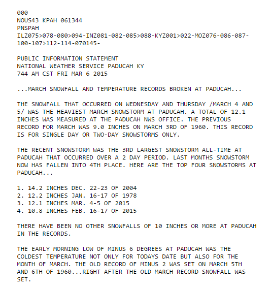
Paducah, KY has had two of its four largest snowfalls on record in the past few weeks. It has also been record cold.
h/t Andy DC
Experts say that record snow is caused by warmth, because they are paid idiots.
Paducah, KY has had two of its four largest snowfalls on record in the past few weeks. It has also been record cold.
h/t Andy DC
Experts say that record snow is caused by warmth, because they are paid idiots.

And you, Steven, are too kind to ‘scientists’ who joined the world’s oldest profession.
By coincidence, Cape Girardeau, MO is only 70 miles NW from Paducah, KY. Snow and ice blocked my driveway so I updated a two-page paper on:
_ Page 1: CHAOS and FEAR in Aug-Sept 1945
_ Page 2: Aston’s Nobel Lecture December 1922
https://dl.dropboxusercontent.com/u/10640850/CHAOS_and_FEAR
Let’s not insult whores–they are honestly providing fantasy for your dollars.
I would not identify anyone in those terms, nor would I stop them from self-identification. That’s why a manuscript on “Solar energy” was posted for open review this year, . . .
https://dl.dropboxusercontent.com/u/10640850/Solar_Energy_For_Review.pdf
. . . and an open message was sent to the Congressional Space Science and Technology Committee in 2013 asking why
1. The internal composition of the Sun was changed from mostly iron (Fe) in 1945 to mostly hydrogen (H) in 1946, . . . (without discussion or debate)?
2. Textbooks replaced Nobel Laureate Francis W. Aston’s rigorously valid “nuclear packing fraction” with von Weizsacker’s convincing but deceptive “nuclear binding energy“ after the Second World War?
https://dl.dropboxusercontent.com/u/10640850/WHY.pdf
PS – The hyperlink to “CHAOS and FEAR” is:
https://dl.dropboxusercontent.com/u/10640850/CHAOS_and_FEAR.pdf
One item that has not been addressed, is what is the heaviest naturally occurring element…
Deep in the center of each terrestial body lies the answer, and it is very doubtful that uranium would win the contest.
John Emsley’s book “Nature’s Building Blocks” contains good information, but we have not surveyed the depths and most likely never will.
That would be a hilarious statement, if only it weren’t true and I agree completely.
I do enjoy Tony’s sense of humor too!
I also see that the fervor over an open arctic ocean and Northwest passage have caused absolute madness.
We can expect Turney type situations magnified by several factors in the near future at both poles:
http://northwestpassage2015.blogspot.com/2015/03/shore-support-vital-for-expedition.html
http://northwestpassage2015.blogspot.com/2015/03/arctic-ship-breaks-free-of-ice-for.html
About time the Rescue Squads get a NON_REFUNDABLE advance payment before the fools are allowed to sail.
Correction for excess bold in last part of my last post:
2. Textbooks replaced Nobel Laureate Francis W. Aston’s rigorously valid “nuclear packing fraction” with von Weizsacker’s convincing but deceptive “nuclear binding energy“ after the Second World War?
https://dl.dropboxusercontent.com/u/10640850/WHY.pdf
PS – The hyperlink to “CHAOS and FEAR” is:
https://dl.dropboxusercontent.com/u/10640850/CHAOS_and_FEAR.pdf
Hi SG/Tony,
From the “encyclopedia anyone can edit”:
The ocean is also a large water body. If the ocean temperature increases, that should lead to greater snowfalls according to the above logic (ie water has to evaporate before it can fall, and as much falls as evaporates).
At the same time, that there darn global warmin’ thang is supposed to increase the mid-tropospheric temperatures, which would… decrease the lapse rate, right?
These are two opposing forces, so to say which one prevails requires quantifying both of them.
Also, the snow can be made by a moving wedge of cooler surface air rapidly uplifting moist air, so even if both “cooler” and “moister” air masses are getting warmer in absolute terms over the years, the snow would be created if the temperature ratio stays the same.
Surely it’s a bit simplistic to say warming (from any cause) does not increase snowfalls?
Maybe it does, maybe it doesn’t, how can any of this be quantified?
Are you thinking that Kentucky is near an ocean?
A warm humid flow from the Gulf colliding with a cold front is exactly what brought on the recent record snow in KY. But THAT is NORMAL! It is nothing new. It’s the same thing that has happened time and again and, when it gets warmer, is more often than not, the same pattern that brings us Hoosiers and Kentuckians the super cells that bring our April showers and spawns our our most violent weather here.
When I was a kid I remember the 1965 Palm Sunday tornado outbreak. I was nearly 10 y/o and I saw my first tornadoes while visiting relative in Kokomo Indiana that day. Three of them passed by just to the south of where I was. It was the same pattern that brought on the snows in KY, just warmer but with a greater contrast in temps. A cold low colliding with warm and moist air.
Yes, but the cold is the primary here. The gradient between high latitude and low is reducing if anything.
Of course not. You used the specific example of Kentucky to reach what I interpreted as a general conclusion about the world: that “record snow is caused by warmth” is idiotic.
(If I were being equally churlish I might ask if you are suggesting there are no lakes in Kentucky, or that there is no moisture in the soil.)
Humidity won’t be significantly removed from the air until it precipitates, so the evaporation can travel potentially a long distance. The point in KY furthest from the ocean is at its junction with Indiana and Illinois, where it is 800km from the gulf of mexico, or further to the Atlantic. The south east corner of Libya, part of the eastern Sahara Desert, is 1300km from the nearest ocean in the Red Sea, yet even this region receives a long term average of 5mm/year rainfall. [ http://www.eoearth.org/view/article/155822/ ] Distance is an impediment to rainfall but not a total barrier to rainfall. It occasionally rains in the Sahara desert and most of that is further from the nearest ocean than anywhere in Kentucky.
Even if you meant “this one record snowfall event in Kentucky cannot be caused by global warming”, you didn’t say that, and since then reader “rah” has pointed out how the proximity of Kentucky to ocean didn’t matter for that specific event anyhow. As long as moist air from the ocean has travelled close enough to the drop zone it can then be uplifted and precipitated by a cold front.
If you don’t know the answer to my original question, that’s okay, just say “I don’t know”. Part of the reason we are in this quagmire is that far too many people have attempted to prop up a visage of omniscience rather than admit they didn’t understand the climate.
The question basically was: How can we quantify the two opposing effects of lapse rate reduction and increased evaporation to determine whether world warming will lead to a net increase or decrease in snowfall quantity?
One could add a 3rd variable, the pole-equator temperature difference, and the answer for snowfall change just gets more complicated.
By this metric clouds cool, so warmth causes cooling. (It does, and negative feedback is real)
If the gradient is decreasing then Florida must be getting cooler based on the temps we have been experiencing up here!
But far be it for the climate alarmist to admit any weather is “normal” and not caused by man. http://newsbusters.org/blogs/joseph-rossell/2015/03/06/msnbc-post-other-media-still-link-snowfall-global-warming
Everyone seems to be missing the point. The jet stream changed from zonal to meridonal.
http://www.noaa.gov/features/03_protecting/images/noreaster-loop-small.gif
Hold your nose and look at the data and not the conclusion of this paper. We already know that the following is a false statement: “… as the Arctic continues to warm faster than elsewhere in response to rising greenhouse-gas concentrations…” In the summer for the last two years the temperature has been below normal. Warming is due to Gavins bright red crayon. (SEE DMI)
Evidence for a wavier jet stream in response to rapid Arctic warming