
After the team switched from tide gauges to satellites for measuring sea level, their reported rise rates magically doubled from 1.6 mm/year to 3.2 mm/year. The tide gauges don’t show this, but calibration never gets in the way of global warming propaganda.
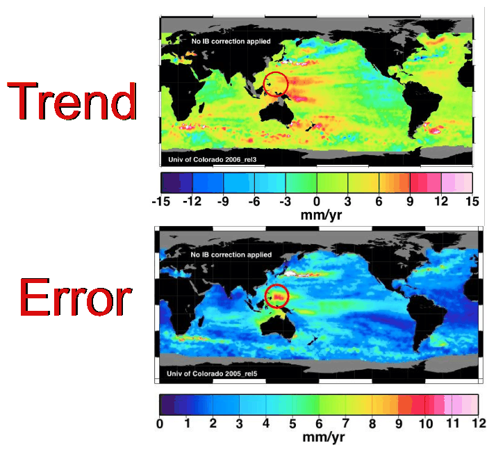
Besides the 100% fraudulent GIA adjustment, much of the reported satellite rise is due to an area east of the Philippines where the error is greater than the trend. Note the red circle, where the trend is 6mm/year and the error is 10 mm/year.
Junk science doesn’t get any worse that that.

http://tidesandcurrents.noaa.gov/sltrends/trends/1612340.png
Forget satellites. I’ll believe them when I see a change in the above link. Trend 1.5 mm per year, with a trend line as straight as laser beam. No continental rebound or fall, it says it all.
I’m more curious about the change from dark blue to yellow off of New England/New York where this difference doesn’t appear to occur anywhere else???
I think it is due to warmer water. warmer water is expanded giving higher seal level in that area?
Is that right Steve?
All the satellite sea level data is a collogue of different sea level snapshots. Since tides are ocean wide in nature instead of local, and they advance across the face of the globe, it is obvious that there should be some hills and valleys in global sea levels.
Here is a little link about long term sea levels in what may be the oldest SL tidal gauge on Earth.
link didn’t load
TRY AGAIN
http://www.john-daly.com/deadisle/
There.
Why do think they switched to satellite measurements in the first place?
Why do they use satellite data. The short answer is, I don’t know. But what I do know is that there are 1260 or so tide gauges around the world and probably as many or more technicians in control of the data. The satellites on the other are few in number, only one or two an any one time producing data and just a few guys, half a dozen maybe, at Colorado University’s Sea Level research Group in control of the data.
I think there are two groups handling the satellite altimetry data. The other one is Avisio, in France. They’re the folks who revised the Envisat data, approximately tripling their previously-reported sea-level rise trend.
I did an independent validation of the Beenstalk et. al. paper on the tidal gauge measurements of sea level rise and arrived at a very similar conclusion to the authors and a conclusion that is well supported by the work of others – a whopping 1.39 mm per year (1980 to present). The present trend is down compared to the trend from 1950 to 1979, which was 2.06 mm per year.
I have no confidence in satellite measurements. There’s too many calibration and technical issues (and adjustments).
http://suyts.wordpress.com/2013/10/21/sea-levels-a-validation-of-beenstock-et-al/
Thanks. Replication >> peer review.
Before post modern science rewrote the rules, and when I was a remote sensing student, we thought we should calibrate remote data with in situ data. But then again, we couldn’t even read thermometers.
You’re 100% correct, Gator (by the way, howdy!). In-situ calibration is absolutely essential to handling remote data. Even in my work we have to calibrate in a sense – account for site differences from our own baseline when doing multi-site studies. Then there’s validation – making sure things make sense and understanding what doesn’t fit and why.
Fortunately, PNS hasn’t crept into my field yet, thank God. We don’t do data adjustments. If we were to adjust and get caught, we would be scorned as conducting bad science. The data is what it is, warts and all. We publish what we find and explain anything in the data that needs explaining rather than making stuff up then covering it up.
Glad to hear at least one branch is still doing science.
I am a chemist and used to run QC labs. Every time I hear about ‘Adjusting data” I cringe. That would get you fired or in jail or at minimum a very nasty session with the FDA.
Science should have the exact same rules as accounting and it used to when I ran a lab. Yes we had computers but everything still went in bound lab books and was dated signed and counter signed so it would stand up in court if need be.
Hello Gail. Good to read you again. Yes, we still do science the pre-post normal science way where data adjusting will get you a new job flipping hamburgers. I’m glad to hear you also do science the scientific way. I think most areas of “real” science continue to reject PNS with a real distain. Unfortunately, many climate scientists found it to provide a direct path to the feeding trough and got on-board with it. History will judge their error and the political tool PNS truly is.
Sadly, science has been largely replaced by Science!. The former is the boring, stodgy practice of rigorous standards, the latter is a glitzy taxpayer-funded press release.
Satellites have been showing a deceleration (decrease) in rate of sea-level rise, but I don’t trust the satellite altimetry data. To understand why, I recommend that you watch this lecture by astrophysicist Willie Soon. Dr. Soon explains the problems with satellite measurement of sea level better than anyone I’ve seen, starting here:
http://www.youtube.com/watch?v=1gmW9GEUYvA#t=17m37s
That segment of his lecture is 24 minutes long, starting at the 17:37 point. The link should take you directly to 17:37. But, actually, I recommend watching <a href="http://www.youtube.com/watch?v=1gmW9GEUYvA#t=0s"the whole 58 minute lecture at least once. I promise, you’ll learn a lot.
I watched that lecture several months back. Dr. Soon does explain the problems the best I’ve ever heard.
“Satellite Sea Level Error Greater Than The Trend”
So this is unlike global temperatures where total aggregated errors are not greater than the trend?
You mean this trend in temperatures? ===> Graph
Yep, that put our little ‘warming’ and hiatus in perspective.h
Only crazed Progressives would cite an increase in Sea Level as Settled Science when the error rate of the instrument is 4 times greater than their trend…
… oh, and please ignore the Tide Gauges… forget how the oldest one in the World shows NO Sea Level Rise… look at this shiny thing over here..
Not only that but the rate of relative sea level rise in the Philippines jumped abruptly (instantaneously) during the 1970 earthquake because of tectonic subsidence and thereafter the rate of relative sea level increased due to continued subsidence.
The obvious conclusion from the data is that the Earth itself is growing larger. If we don’t tax carbon, the Earth will [continue to] grow [exponentially] until it consumes the whole Solar system, in which case we’ll have to rename it the Telluric system.
I’m going to need a $2500000 grant to study this problem further.
If you get the grant, I’m available to assist with the statistics and modeling. I even know how to make hockey sticks out of nothing at all 😉
If I hire somebody else to help me fake the numbers, I’m going to need a bigger grant. You can struggle by on $4000000 a year plus benefits, right? That’s pretty fair for a future Nobel Prize winner, I think.
No problem with the salary and benefits. I think all we need is some GPS and survey equipment, some travel time (mostly to tropical islands as we want waist line measurements) and, of course, unprecedented results that will require further grants to make more robust.
Parenthetically: since the Earth is getting larger, your dollars will be getting larger as well. I think you can see where this is going.
Absolutely. Hansen, Mann, Trenberth, Jones, and the rest got started of with visions of granture.