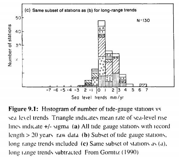
On Friday, Trenberth said that satellites can measure sea level to one mm and prove that the oceans are rising 3 mm/year. He forgot to mention that the 1990 IPCC report showed that most tide gauges report less than 1mm/year
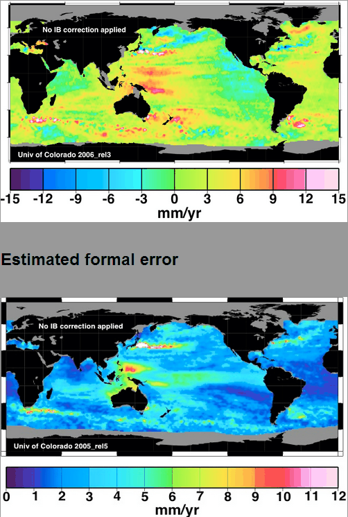
He also forgot to mention that the error from satellites is about 90% of the measured trend


I agree with the satellite temp errors, but where are they coming from? Is this mostly error in the drift of the azimuth angle between the ground receiving station and satellite?
Anyway I sure am glad that this cannot be corrected by “aerosol” (the correction is the wrong direction).
Kevin Trenberth cannot believe his own eyes, that is the principal difficulty. He has access to any data that anybody else has and he simply cannot believe it. He got hung up on a 3 W/sq m “GHG Forcing” that he invented that unfortunately manifested itself no where, and all he has left to maintain his ego are shrill shouts of “denier”
A very sad situation
Gravity anomalies, tides, waves, satellite issues …. The surface of the sea varies by metres from second to second..
That’s true, but looking at all the errors, I don’t think there are any as large as |d(theta dot)||theta| over any time period where d(theta dot) is the error in time of the estimated azimuth
Also the wavelength of the radar induces a small error.
There’s a bunch of aerosols making “corrections” to temperatures.
Not believing his own eyes, Trenberth concocted the “deep heat” scenario, rather than admit he is wrong.
Looking at the Ocean this morning I find its massive undulation on a second by second basis plus the swing in tides due to the Moon, Sun and all the planets a very difficult task to “normalize” down to mm per year… this is all modeling, speculation and software… but please, keep trying..
Meanwhile Tide Gauges have provided consistent and accurate data over a large period of time. These seem to be ignored by the technocrats working at the IPCC because their readings don’t support the great flood…
How do they do the IB correction for satellites? It must take at least a day for a satellite to measure sea level over the whole globe – more like weeks for a small measurement footprint. Do they then calculate the instantaneous (modeled – no measurements in a lot places) surface pressure as the satellite passed over?
I just clicked on my shortcut to :
http://sealevel.colorado.edu/
Forbidden
You don’t have permission to access / on this server.
I’m curious if it’s just my terminal or does everyone get this?
No problem. Interesting it show the sea level is dropping in the short term.
Well anyway, that terse message aside, a trip to the Internet Archive’s WayBack Machine demonstrates how the satellite data has been changed since 2004
The first GPS systems helped the refinement of the understanding of Earth Tides. The solid earth moves by up to 2 metres up and down depending on the position of the moon and the sun. Ironically, the GPS satellites proved that there is actually no solid unmoving benchmark on this earth. In the vertical plane the first GPS satellites were only accurate to the nearest decimetre – 100mm – approx 4 inches. These brain surgeons that can measure the sea level to the nearest millimetre also have a bridge to sell.
http://sealevel.colorado.edu/
They’re back up.
I get kicked of off CAGW websites on a regular basis so I’m a bit paranoid about it.
3mm per year is about the historical average. Last time I bothered to do the math, 100 years X 3mm = 300 mms per century. That is ~ 1 foot per century, ~1.2 inches per decade.
Trenberth is playing people for fools if he thinks ~1 ft. per 100 years is a problem that requires doing what a bunch of non-civil engineers have to say about civil engineering infrastructure- Trenberth and gang are not engineers. Trenberth, and far too many of his colleagues do, however, act like hucksters.