
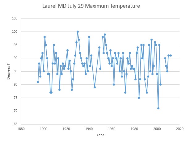
Laurel, MD is currently 68 degrees (1:30PM) and not warming. The previous coldest July 29 maximum was 71 degrees in 2001. In 1930, it was 100 degrees on this date.
Laurel, MD is currently 68 degrees (1:30PM) and not warming. The previous coldest July 29 maximum was 71 degrees in 2001. In 1930, it was 100 degrees on this date.

It’s 73F in Denver right now and EPA is holding a hearing on the proposed “carbon” emission reductions. http://www2.epa.gov/carbon-pollution-standards/public-hearings-clean-power-plan-proposed-rule-denver-co
Meeting should be called due to lack of interest.
Steven – please check the 6-10 day forecast:
http://www.cpc.ncep.noaa.gov/products/predictions/610day/610temp.new.gif
and the 8-14 day forecast:
http://www.cpc.ncep.noaa.gov/products/predictions/814day/814temp.new.gif
another cold blast coming down!?!?!
feel free to make this a new post if warranted.
Thanks. That will make for interesting material in coming days.
Here in my little part of WV, it hit a high of 63, earlier this afternoon, and if the cloud cover breaks over the next couple of hours (almost 4 pm as I type this, we may get near the record of previous record of 69…it ‘should be’ in the 80s right now). It was also, 11 F, below normal, yesterday, with the high for the day occurring at 12:15 AM. The low last night was 50…not quite a record, but if the clouds do clear out, I expect there to be a chance of low 40s (or even upper 30s), for tonight.
Three hours later…topped out at 65F and clearing skies. The record low of 44F might have some stiff competition, tonight.
Here in Upstate NY it was like October yesterday. A high, thin milky cloud layer with fatter clouds below gave it an eerie look.
Last night was blanket cold with windows closed and this has been true for much of July. Two days sun, three days rain, too which reminds me very strongly of the mid 1970’s Tiny Ice Age Warning years.
I am frantically getting ready for winter, need to chop and cut at least seven cords of wood and all my neighbors are building epic wood piles this summer.
It was 59 here in NC last night with some towns getting as low as 46°F. It is normally ~ 70 °F for a low this time of year but didn’t break the record.
September-like here: http://www.al.com/news/index.ssf/2014/07/record_low_temperatures_felt_a.html.
“Normal” low = 70F, “normal” high = 90F, pretty much from mid-June through early September. “Normally”, we don’t get cold fronts at all where I am from mid-June to the mid-August autumnal blast. We occasionally get back-door systems when strong highs nose down the Appalachians, giving us Atlantic air-masses instead of the typical Gulf or Pacific ones.
If you look at that map in the link, look at the darker blue colors and even look at the lighter ones down in Florida. Remember what I said about mid-latitude storms and their cold fronts not reaching me in a ‘normal’ summer and look at the fact that this cold front made it to central Florida, *in July* and late July at that.