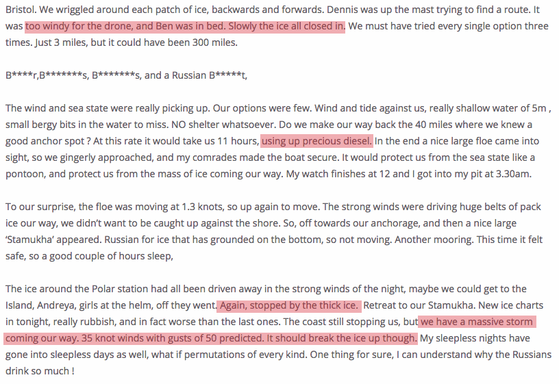
Even with a drone to find a route through the ice, and huge amounts of diesel fuel, the only thing that got the Ship Of Fools through was a massive storm which broke up the ice. Apparently climate experts believe that the Arctic never used to have storms before.
What model of drone did Amundsen use when he said the Northwest Passage was open in 1904?
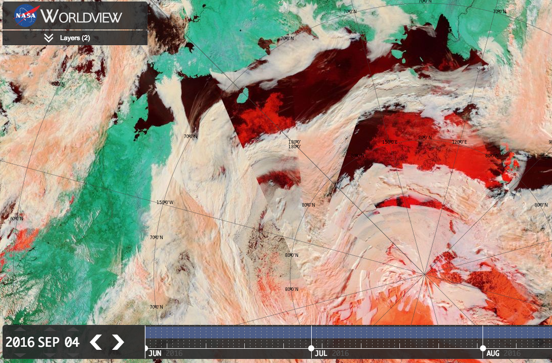
The big story in the Arctic this year is the massive expansion of multi-year ice towards Russia, where there hasn’t been any for quite a few years. The same ice that trapped the Ship of Fools, and caused them to curse and drink vodka for weeks.
Think = thing
Polar Ocean Challenge = Propaganda Stunt
But if you were to read their press release on their home page, http://polarocean.co.uk/ , you might think they hardly saw ANY ice at all.
“The North West Passage was completed in an astonishing 14 days due to the fact that it was almost totally ice free. They encountered ice only twice in their 1800 mile NW Passage part of the voyage. This highlights an extraordinary loss of sea ice in the Arctic in the 30 years that David Hempleman-Adams has been coming to the area. ”
Now their time of completion cannot be reasonably compared to others, because they didn’t actually do what others have done. They did not cross the arctic circle at the beginning of their northwest passage, likely because if they had done so, the time taken would have made it unlikely they could have avoided oncoming freeze. The race they ran was different from others.
Numerous times in the logs and blogs it was mentioned how they got lucky. If there really was so little ice, then luck should not have been needed or played that big a role. In the logs they also mentioned how a given short-cut was blocked by ice, or how a more preferred route could not be used due to ice. If there really was so little ice, there should not have been so many routes and short-cuts blocked by what isn’t supposed to be there. They had access to ice charts. They plotted their course to as much as possible avoid ice. And they have the gall to say in effect “wow, we hardly saw any ice!”. Of course you didn’t. You always picked the other routes and went the other way.
I’m sorry, but that’s nonsense… did they sail the Amundsen route through the NW passage? yes they did.
As did a stonking great cruise liner.
There was no ice in the NW passage southern route this year.
http://nsidc.org/arcticseaicenews/
Nevertheless, taking advantage of mild sea ice conditions, the 68,000-ton Crystal Serenity set sail from Anchorage, Alaska on August 16 for its 32-day journey through the Northwest Passage via Amundsen’s route. This is the largest ship thus far to navigate the Northwest Passage and is accompanied by an icebreaker ship (which it did not need!) and two helicopters. The ship sailed through the Northwest Passage in less than three weeks—52 times faster than Amundsen’s nearly three-year voyage.
On the other side of the Arctic, the Northern Sea Route appears mostly ice free.
Crystal serenity might be big but it only draws 25 feet – not so big.
A dirigible is huge but its only hot air……
“A dirigible is huge but its only hot air……”
as is Griff
Neither of the current voyages sailed Amundsen’s route exactly. Neither of them did the loop around King William Island, but they both took the shortcut south of Somerset Island, which Amundsen did not. He sailed by the West side of that Island, while they sailed up the East.
The pioneering route most like the current voyages is that of the St. Roch, in 1944.
… And, since there is (as of the 12th) up to 1 m thick ice on in the channel north of Somerset, Amundsen’s route is currently impassible.
Neal,
I’m sure you noticed the disconnect between the frank descriptions of their close calls in the expedition ship’s and crew logs on one hand and the official propaganda on the website and in the press releases. It’s a curious thing that makes me wonder if Hempleman-Adams is an agent of Big Oil on a mission to discredit the AGW hypothesis. Who gave them all the diesel? :)
The alarmists commenting here seem to have a genetic advantage of immunity against the effects of cognitive dissonance (but then I repeat myself).
I sent them an email and let them know how disappointed I was that they felt they needed to lie about their achievement of circumnavigating the pole. Neither east nor west passages were completed.
If you look at the ice alarmists sites they were salivating this melt season. They became hysterical with joy when one of “lowest” ever pressure systems developed late in the season. But all the thick multi-year ice hung around much too their chagrin. But alas they’re now saying the ice is finally set up for the “black swan” event to come next year!
Yacht sails through low-ice Arctic sea routes
By Jonathan Amos BBC Science Correspondent
http://www.bbc.com/news/science-environment-37351271
Don’t you bother to read the comments on your own blog Tony?
FYI what got Northabout through was experience, determination, skill and of course ice melting. Maybe the vodka helped too?
What “massive expansion of multi-year ice towards Russia” are you referring to? FYI here’s the Russian map of MYI on May 31st 2016:
No Jimbo, what got them through was the availability of satellite sea ice charts to tell them where they had the best chance to get through, AND WHERE TO AVOID… and weather charts to have them in the right position to take advantage of a storm.. without those continually updated charts, they would have taken a few more weeks to get through the Laptev, and would never have got to the NW passage in time.
Even in the NW passage there was so much sea ice blocking main northern route, the Banks Island route as followed by Larsen in 1944, even the Amundsen route was impassable. Fortunately they had the satellite sea ice charts to show them all this, to show them that they HAD to uses Bellot Strait as the ONLY way to get through, then chew up heaps of fuel in a race to beat the increasing sea ice.
Evidently you still haven’t watched this video carefully Andy:
https://youtu.be/g9JHSs38G-Y
Try reading this too:
http://GreatWhiteCon.info/2016/04/the-beaufort-gyre-goes-into-overdrive/
Tell us why they were stuck so long outside Vilkitsky Strait , Jimbo.
Could it have been anything to do with LOTS of sea ice?
Good thing they didn’t try earlier, hey.
Face it Jim they got lucky at Vilkitsky Straight. The Russian ice breaker was working overtime escorting multiple convoy’s through the straight. All that ice breaking couldn’t have anything to do with their ability to get through? And right now as we type the Prince Regent sound into Lancaster Sound would be impassable without help. So yeah they made and so has the sea ice! You guys have been going on since 2007 about the demise of Arctic sea ice NINE freakin years. Why is it still there?
Closed for winter!
http://iceweb1.cis.ec.gc.ca/Prod/page3.xhtml
This is why its still there…
An interesting chart. According to the equation, arctic ice has been expanding an average of 10,000 sq. km. per year over the last ten years. Overlooking that a mere 10 years is nowhere near long enough to establish long scale changes, it suggests an increase of 0.2% per year over this period (thus perhaps 17% by 2100). There is also no obvious evidence of it accelerating, one way or the other, though a first derivative plot is needed to determine that.
Has anyone here ever tried flying a drone in a massive storm?
With the pilot several thousand miles away?
https://youtu.be/A-aN36DXzNg
Admiral Hunt, you must concentrate on strategic Admiralty planning and the biggest threat to mankind—catastrophic global warming—a grim testament to greenhouse gasses.
Leave the pesky expedition details to the underlings. You don’t want to be bothered with the minutiae and there is a remote chance some ill-wishing denier could say you have no clue what you are talking about.
Sep 13 2016:
There are some nice aerial pictures that Ben’s father took with the ship’s drone for the Admiralty files:
https://www.youtube.com/watch?v=3_rH48q5YkU
Ben’s father joined the boat in Tuk.
Have you seen any drone footage of leads through the ice?
Brilliantly executed, Admiral! Only The Father could fly the drone and you held him back so they couldn’t use it!
Your underlings had to do with an old-fashioned diesel engine with 2000 ltr fuel tanks, a hydraulically operated lifting keel, two power generators, solar panels, solid state radar, two satellite communication systems, weather maps, ice maps, microwave, bread maker and vodka.
Nobody can accuse your sailors of having some advantage over Amundsen.
What?! They disobeyed your orders, Admiral! Someone other than The Father was operating your drone during the voyage!
Aug 8 2016:
Hundred lashes each with a cat o’nine tails and throw the mutineers in gaol!
Wotta lotta sea ice:
https://youtu.be/cHE1gLMBIHY
At the risk of repeating myself:
“Have you seen any drone footage of leads through the ice?”
To His Excellency James Hunt, Admiral of the Fleet
My Dear Sir,
I understand that the biggest threat to the British Empire—and dare I say to all of mankind—demands the undivided attention of his Excellency, but may I have the honour to beg the Admiral to assign officers on his staff to review the expedition logs of his Arctic expedition? I would be flattered if the Admiral’s Aide-de-Camp reviewed the practicality of requesting from the Fleet’s ships on high seas ongoing dispatches of operational visuals through constricted ether.
I remain Your Excellency’s most obliged and obedient servant.
If we look at the routes of past explorers, we see than any of the routes inside the red line were impassable. Good thing they knew this in advance and could pick out their rout using satellite sea ice charts, thus avoiding the massive amount of sea ice BLOCKING ALL ROUTES BUT ONE.
Cheaters eh? Which century are you living in? Ironically the current science gives you information to bash them over. Otherwise you would not hear about it till a lot later and have to read a book or newspaper.
If you think it’s a cheat go up there and do it without modern tech? Yes?
Andy
Where did I say they cheated.
Just that modern technology was the ONLY thing that made the trip possible.
There can be no doubt that without constant sea ice chart and weather updates, they would have failed miserably.
Amundsen’ route was impassable
Larson’s 1944 route was absolutely impassable
But they knew that well in advance , so avoided those blocked sections.
They knew so far in advance that they posted the bleedin’ obvious route through Bellot Strait on their web site long before they got anywhere near the Northwest Passage.
http://polarocean.co.uk/calendar/
They originally planned to go south of Novaya Zemlya, but there was so little ice in the Kara Sea they went north instead.
I expect they found weather forecasts handy. Constant sea ice charts less so.
You seem to be saying that they knew the main passage would be blocked even before they left.
I can accept that.
It would be interesting to go back through their blog and see how many times they were waiting for new sea ice charts so they could make decisions.
Feel like doing that, Jimbo, or don’t you like egg on your face.
I think you’ll find that AndyG is all mouth and no trousers:
https://realclimatescience.com/2016/09/we-are-in-a-race-against-time-before-the-freeze/#comment-21019
What a moronically meaningless comment.
You KNOW Amundsen’s route was impassable
You KNOW Larsen’s 1944 route was impassable.
You KNOW they were guided to the ONLY open route by satellite sea ice charts.
Run and hide from the truth as is your ONLY mode of operation.
See above!
See above..????????
All I can see is a big map showing that ALL routes except the one they took were blocked.
LOTS of sea ice in the way.
And most of all, you KNOW that without access to those modern sea ice charts, they would never have got within cooee of getting through.
You know you can prove me wrong about that, by being a true admiral, and attempting it without sea ice chart access next year. Make sure you take plenty of nappies.
You can prove me wrong by donning your polar bear suit and taking on Cotty on the biggest waves we can find in the Arctic Ocean:
Diversion and running away hey Jimbo…” oh look over there…”. very childish, even for you.
This is about you DENYING satellite data provided massive help in sailing around the Arctic..
It has nothing to do with your egotistical surfing stories…. who knows where you dragged that totally unimportant, unrelated load of tripe up from.
” and huge amounts of diesel fuel”
How much is huge? Do you have any real science figures on the subject?
You claimed they would have problems getting through the NW passage as cold days ahead and yet they didn’t at all, the ice is not there.
Their biggest mistakes were to go the wrong way around in hindsight, also they linked their adventure to climate when adventures do not need some sort of reason, apart from “because it is there”. The climate angle was bogus but probably got them some money or interest.
Having said that, fantastic achievement. The storms did not break up the ice as Tony claims when they were icebound on the Russian side, it was just late melt. The winds gave them a rough time after, but actually helped them speed to the NW passage, if they had no winds they might have run out of time. As always a lot of luck plays a part.
Good work though. :thumbs up:
Andy
“The storms did not break up the ice as Tony claims when they were icebound on the Russian side, it was just late melt. ”
Comments from the young lad show it was very fortunate.. it closed up right behind them, and then remained unpassable for another week or two.
They were running purely under fossil fuel power from well before Bellot Straight. No sails used at all.
PS There was not a massive storm like 2012 but 2 smaller ones and until we get the analysis on the melt season you cannot say if they had a negative or positive effect on ice extent.
So the statement on storms being the reason they only got through is just assumption currently.
Andy
If they got through laptev due to melting ice, how could it close up behind them.
(It would be melted … wouldn’t it?) Didn’t you read their blog posts about this? Didn’t you see the ice charts from before and after they snuck through?
You can try to close your eyes, put your fingers in your ears and yell ‘LA LA LA’, but the fact remains (whether you believe it or not, understand it or not, acknowledge it or not) that it was not melting ice that allowed them through the laptev sea.
Yep, their logs clearly show that, from satellite weather maps, they knew the wind was coming, and had positioned themselves in the hope that they would somehow get through as the wind pushed the sea ice off shore temporarily.
“Got a whale of a tale to tell ya, lads
A whale of a tale or two…”
As an outsider looking in, here’s my
reaction to the entertaining dialogue
above.
The navigation through
the NW Passage is undeniably an
accomplishment, albeit, one that very
well might not have happened at all without a dazzling
array of state-of-the-art technology that was unavailable to
Amundsen and to the 1944 expeditions that both failed.
Projected commercial voyages via similar routes
will have to await further developments. Both the
1904 and 1944 attempts followed periods of contemporaneous
warming in the NH. Whether Arctic ice further declines sufficiently to
make the journey reasonably safe for commerce will depend
entirely on the whether the Modern Warm Period is currently
in pause or is about to come to a conclusion to be followed with the
onset of another cooling period.
Time will tell. The GCMs are useless in this respect.
Where are my comments? I spent a good 30 minutes crafting
a coherent observation to what transpires above. On clicking
“Post Comment” they disappeared. I am not amused.
Try refresh.
I see two comments by you. (Try to remember to save a copy for when the internet burps and your comment gets memory holed.)