
The map below shows all of NOAA’s Joaquin forecast tracks since September 30 at 11:32 PM. It also shows their “Forecast Uncertainty” from September 30 in turquoise.

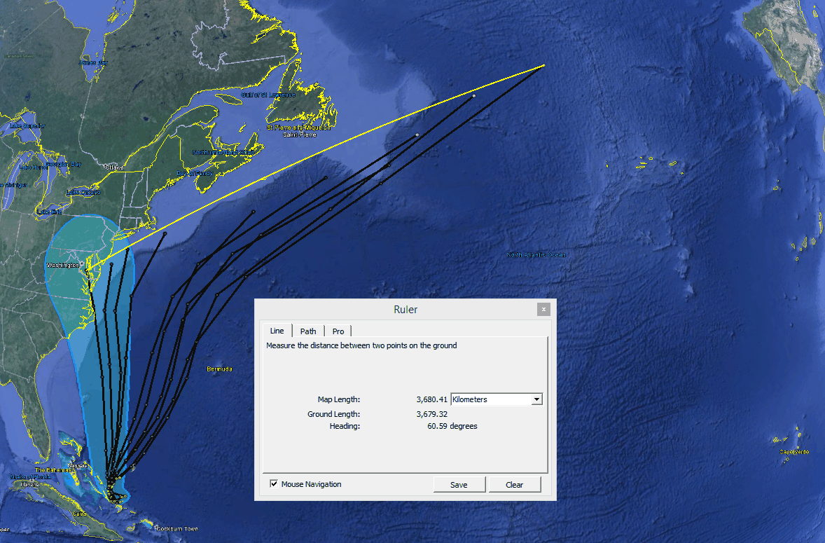
Their current forecast is thousands of kilometers outside of their September 30 “uncertainty” – indicating that they actually have no idea how accurate their forecasts are and are simply making certainty numbers up.
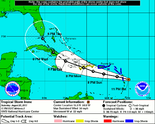
With Hurricane Irene, they forecast landfall at every Eastern Seaboard state at one time or other, and then declared victory when one of their forecasts came true. They bet on every horse in the race.
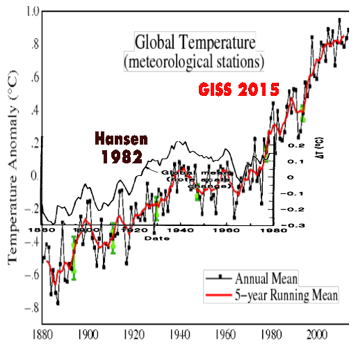
And NASA does the same thing with temperature, adjusting temperatures far outside of their own error bars.
The abuse of data at US government agencies is astonishing. The only thing that is certain is that their certainty is meaningless.

Who remembers when hurricane Andrew was east of the Bahamas…..they had the “cone of death” from Cuba to New York. And it was less than 300 miles off the coast of Florida
They bet on every horse in the race.
By updating their forecast as often as they do…..they can claim accuracy like that
Just exactly what one would expect from government bureaucrats. Excellent presentation Tony.
It just goes to show how incredibly ROTTEN the Climate models are. If they can not forecast something like the track of a hurricane, with all the data and all the computer capacity they have, then how in HADES CAN THE FORECAST the weather 100 years from now?
It’s not the end of the rain in the east.
http://earth.nullschool.net/#2015/10/04/1500Z/wind/isobaric/250hPa/orthographic=-93.58,37.35,690
Thank you REN,
I really did not want to hear that. My goats sheep and horses are growing gills like fish. I can not get my winter grass planted either.
Even more telling, Irene was declared to be a hurricane in spite of the fact that by the time of land fall, it had dropped to tropical storm status. It is just that “hurricane” sounds so much more dramatic!
Here in mid North Caroline it has been a PITA with rain for days and a bit of heavy rain last night, but no high winds.
Sorry.
http://earth.nullschool.net/#2015/10/04/1500Z/wind/isobaric/850hPa/overlay=mean_sea_level_pressure/orthographic=-84.12,34.81,1585
Gail
I’m sorry, but tomorrow the most rain in North Carolina.
Gail Combs the jet stream is highly visible in the animation of water vapor.
http://www.accuweather.com/en/us/national/satellite-wv?play=1
Greetings, my name Ireneusz.
file:///C:/Users/irek/Downloads/West%20Pacific%20Basin%20Typhoon%20%26%20Tropical%20Storm%20Center%20-%20Hurricane%202015%20-%20AccuWeather.com.html
Thanks, Ireneusz
It has been light rain all day. The river near by is full but no flooding like South Carolina. Some tree branches down and some strong wind. We were lucky.
I am very happy.