
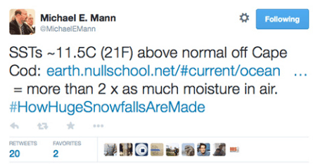
Mikey is severely math challenged, but shows off an important point.
You can’t extrapolate temperatures across ocean/land boundaries like NCDC does. The Gulf Stream is warm off of Massachusetts, but Massachusetts itself is frozen. There is a sharp dividing line at the coast.
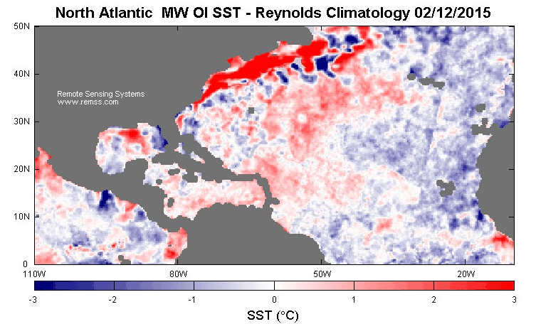
GISS extrapolates 1200 km, which is like making the Liverpool weather forecast based on the weather in Nice, France.

I personally feel sorry for Dr. Michael Mann, a relatively new PhD who was controlled and used by propaganda artists by over-inflating the ego.
Almost the entire physics community suffered the same fate after WWII. It is true that physicists like Einstein, Planck, Schrodinger, DeBroglie, etc., had made great contributions to science.
But Stalin apparently inflated their egos to such an extent that they ignored superior discoveries by a few talented chemists, like the discovery by Richard Harkins in 1917 that the more stable elements were more abundantly made [seven elements (Fe, O, Ni, Si, S, Mg and Ca) constitute 99% of the material in the Earth and ordinary meteorites] and Francis W. Aston’s measurement and report of the exact atomic mass of each atom expressed as “the nuclear packing fraction.”
Thus, most of the physics community became insufferably arrogant after WWII and vulnerable to use by Stalin.
Nobody put a gum to Mann’s head, he has lied and cheated willingly. If you wish to feel sorry for someone, feel sorry for the millions who are suffering as a result of the fraud Mann is continuing to support..
Make that a ‘gun’, gum is what is inside of his head.
Besides that as a person he is a rather nasty little twit.
+100000
http://www.masslive.com/politics/index.ssf/2015/02/forum_on_climate_change_postpo.html
lol snow storm cancelled a warming conference must be hot!
Will continue to freeze.
http://www.wetterzentrale.de/pics/Rhavn1803.gif
Ocean moisture would be blown off to the East. Right?
Not necessarily. Look at ren’s chart. Since the jet stream has gone meridional (Loopy) the winds at my farm in the piedmont of NC have gone from always out of the west, unless we have a hurricane, to coming from all points of the compass including from the east.
This means you can get that nice warm moist ocean air hitting that cold polar air and dumping snow along the coast.
This is the North Atlantic and you can see the loopyness and the fact the winds are not always out of the west:
http://squall.sfsu.edu/gif/jetstream_atl_init_00.gif
Thanks Gail. I meant, in Feb 2015 so far. The winds are still blowing from the west, in the area with high SST. Correct?
Does NASA GISS in general extrapolate only or mostly warm land anomalies into the oceans? Or mostly warm ocean anomalies into the land?
I know they have ignored SST in the polar regions, and extrapolated warm land reading into cold SST regions at both poles (Just looking to see how to quantify their mad adjustments.)
And that is just it in my thinking. I am still waiting for Mosher to detail how the algorithm changed just one station in Iceland. If they cannot explain one station, and justify why it is not only clearly wrong, (and just happens to mimic the overall adjustments to the entire record, cooling the past, then it is pointless to attempt to explain the entire FUBAR surface record.
Mann is wrong. Dr. Roy Spencer points out that Boston has been getting drier.
“The following plot shows that the observed total January precipitation in Boston has actually decreased since the 1930?s, contrary to the average “projections” (in reality, hindcasts) from a total of 42 climate models, at the closest model gridpoint to Boston:”
http://www.drroyspencer.com/2015/02/winters-in-boston-becoming-dryer/
Colder is normally drier. Also
http://sparkleberrysprings.com/v-web/b2/images/climate07/04mcabefig4lg.png
The great debate is going to be settled
https://orach24463.wordpress.com/2015/02/12/the-manchurian-candidate/
Well it’s cold out there folks. Delivered in Bolton, ON (a few miles north of Toronto) this (Friday) morning. When I arrived there at 00:30 and backed in between two sets of doors the thermometer on my truck which seems pretty darn accurate read -6 deg. F.
A few minutes later two Canadian owner operators that drive to the company I work for arrived. As one was backing his trailer both glad hands broke. Glad hands are the connectors for the airlines from the tractor to the trailer. The cheaper ones are made with a die cast body. Die cast does not do well under stress in very cold temps.
I always keep a spare new air line and glad hand in my box of parts and gave it too him and loaned him an adjustable wrench. Without getting at least the red side airline fixed he could not move. He also managed to put a good one together using his old ones and so he had what he needed to make it to where a more permanent fix could be made. Poor guy was out there for an hour working with bare hands in that temp. Hard way to learn a lesson about inspecting your equipment, keeping spares and the tools to use them, and understanding that you get what you pay for. But I doubt he forgets it.
BTW the snow cover between Windsor and Toronto seemed to range between 4 and 8 inches. But since they hadn’t had a major snow for a few days the road conditions were excellent.
I left my truck set on “idle management” when I parked it this evening because the temps here in central Indiana north of I-70 are forecast to drop below zero Saturday evening/night with enough wind to bring in -25 wind chills.
For some reason I suspect that this may be old man winter’s last big blast of arctic air down here this season.
Reblogged this on Centinel2012 and commented:
Its easy to make cool pictures to show what you want, but that is not science. It would seen the these guys have come from Dream Works not MIT or Cal Tech
It is time to address the conflict that world leaders [1] have with God [2].
1. UN’s Agenda 21:
http://habitat.igc.org/agenda21/index.htm
2. The Higher Power that makes and sustains every atom, life and world in the solar system:
https://dl.dropboxusercontent.com/u/10640850/Solar_Energy_For_Review.pdf