
A disconcerting report released last week revealed that New York City could see a 6-foot rise in sea levels by the end of this century. It would make nearly half a million New Yorkers vulnerable to flooding, and waterfront properties would be virtually uninhabitable.
Here’s What Will Happen To New York City If The World’s Ice Sheets Melt
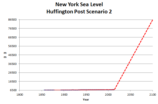
Sea level has been rising at a constant rate in New York since 1860, due to glacial rebound after the last ice age. It shows no sign of accelerating. The dashed line below shows the mindless Huffington Post forecast.
But what if climate change continues unabated for even longer? What will New York City look like if, say, both the Antarctic and Greenland ice sheets melt completely, raising sea levels an estimated 260 feet?

Doesn’t get any more stupid or dishonest than this.

The whole ‘Sea Level Rise’ story is just like the rest of the CAGW myth, manufactured propaganda!
One problem is the sea level data is not raw data but adjusted data.
The second problem is the earth has been cooling since the Holocene optimum, glaciers have re-established and the sea level has FALLEN. Amazing how the ~ 1.5 meter fall in sea level since the Holocene Optimum never shows on any of the sacred graphs.
Mid to late Holocene sea-level reconstruction of Southeast Vietnam using beachrock and beach-ridge deposits
Sea-level highstand recorded in Holocene shoreline deposits on Oahu, Hawaii
Verification by another method:
Sea Level Changes Past Records and Future Expectations
Glaciers:
Ice free Arctic Ocean, an Early Holocene analogue
Is there anything that the ClimAstrologists have not manipulated and twisted out of all recognition?
ALL four legs upon which the CAGW scare is based are manufactured. Above I showed how the Sea level data is ‘adjusted’ to show rising not falling sea levels.
Tony and others show the temperature records are adjusted to fit the rising temperature narrative. Lief Svalgaard and his buddies are busy adjusting the solar data to flatten out the solar minimums. To down play any solar influence.
And then there is CO2 which is neglected by skeptics. (Thanks to the warmist Englebeen on WUWT.)
CO2
Jaworowski, Segalstad and Ono showed the ice core CO2 records are consistently too low. Ernest Beck showed the historic CO2 records were cherry-picked. http://www.co2web.info/ESEF3VO2.htm
Jaworowski and Segalstad showed the IPCC’s CO2 residence time (lifetime) of 50-200 years is completely bogus. Stumm & Morgan (1970), Murray (1992), and Segalstad (1992) all came up with ~5 years by different methods. With such short residence times for atmospheric CO2, Essenhigh (2009) correctly points out that it is impossible for the anthropogenic combustion supply of CO2 to cause the given rise in atmospheric CO2. Consequently, a rising atmospheric CO2 concentration must be natural.
Dr. Jeff Glassman shows the well-mixed conjecture is invalid. By losing its long residence time assumption, the Consensus finds its well-mixed conjecture invalidated. The admission in the TAR of CO2 gradients over the globe also contradicts its well-mixed claims….
And to round it off Segalstad shows Ocean Acidification is bogus. http://www.co2web.info/
When you actually look into the science behind each of the legs of the CAGW con you find nothing but shifting sand.
It’s a broken cue stick.
Yes Virginia the historical sea level data is constantly rewritten. Here’s a comparison of data as it was in 2004 and ten years later in 2014.
http://oi59.tinypic.com/24e8482.jpg
Or Carolina, for historical perspective.
Looking at the effect sea levels have had over the past 230 years, what has been the result. See – An Accurate Map of North and South Carolina With Their Indian Frontiers, Shewing in a distinct manner all the Mountains, Rivers, Swamps, Marshes, Bays, Creeks, Harbours, Sandbanks and Soundings on the Coasts, ’1775′ – http://dc.lib.unc.edu/cdm4/item_viewer.php?CISOROOT=/ncmaps&CISOPTR=125&CISOBOX=1&REC=15
from NC Map
Compare with a side by side google map and most of the features are still there. A side note that 1775 was at the end of the Little Ice Age and a whole lot of ice was on shore – See Glacier Bay NP.
Glacier Bay was first surveyed in detail in 1794 by a team from the H.M.S. Discovery, captained by George Vancouver. At the time the survey produced showed a mere indentation in the shoreline. That massive glacier was more than 4,000 feet thick in places, up to 20 miles wide, and extended more than 100 miles to the St. Elias mountain range
That’s 1 watershed valley.
A disconcerting report released last week revealed that New York City could see a UFO invasion by the end of this century. It would make nearly half a million New Yorkers vulnerable to body snatching, and the rest would be kept in stock yards for butchering.
Anyone can write fiction.
Change NYC to DC and I’m ok with that.
I bet if we rebroadcast Orson Welles’ reading of H.G. Wells War of the Worlds in D.C. we could panic all the Congress critters.
It was originally broadcast on Oct 30, 1938.
Surely glacial rebound causes sea level fall? Local sea level rise is generally caused by subsidence. For example, Northwest Scotland is seeing a relative sea level fall due to glacial rebound while Southeast England is seeing a relative sea level rise due to subsidence.
Glacial rebound causes sea level to fall in the north, and rise in the south. It is like a teeter totter, or seesaw as they are called in the UK. The subsidence in southern england is due to the same effect.
OK. I can picture that.
Notice how MSM articles like that never include a graph of what SLR has been like up til now, and compare with their “projections”?